Details: Governor Basin 
Distance: 5.8 - 7.6 miles (round trip)
Uncompahgre National Forest, near Ouray in Southwest Colorado
Hike Facts
- Distance: 5.8 - 7.6 miles (round trip)
- Elevation: 10,715-ft. - 12,800-ft.
- Elevation Gain: 1,275-ft. - 2,085-ft.
- Difficulty: moderate-strenuous
- Trail Highlights: See Trail Intro
- Basecamp(s): Ouray
- Region: Southwest Colorado
Ascend a scenic jeep road into the heart of Governor Basin, explore the Mountain Top mine ruins and then follow a route to an overlook with impressive views of the high peaks of Yankee Boy Basin.
Trailhead to Governor Basin
Distance from Trailhead: 5.8 miles (round trip)
Ending/Highest Elevation: 11,990-ft.
Elevation Gain: 1,275-ft.
This description assumes you start this hike from the Governor Basin Road pullout just past the intersection with the Yankee Boy Basin Road. (See driving directions below). From the pullout, the Governor Basin road curves to the left, passing the gated road to the Walker/Ruby mine. Beyond the mine the road crosses a wood bridge spanning Sneffels Creek, climbs a few switchbacks and then ascends southwest on moderate grades.
Potosi Peak’s (13,786-ft.) rugged slopes tower above the road to the northeast while Stony Mountain (12,698-ft.) rises to the west. Ahead the jagged profile of the San Sophia Ridge fills the skyline.
At 0.7 miles the main road curves to the left, passing a side road blocked by a gate, and soon crosses a creek. The road now narrows and enters the trees as it climbs moderately-steep to steep switchbacks. Openings in the trees offer fine views of Teakettle Mountain and Potosi Peak to the north/northeast. Soon Cirque Mountain joins the scene. The unattractive area along the valley floor the east is the Revenue Mine.
At 1.4 miles the road veers right at a hairpin curve. Ignore the two lesser roads branch left toward Sidney Basin. The grade now moderates and the trees thin. Lovely alpine meadows offer ever improving views of the surrounding peaks.
Reach a second junction at 1.7 miles. The signed road to the left also leads to Sidney Basin, creating a loop with the previously passed roads. We continue straight ahead on the Governor Basin Road.
The trees now give way to meadows and fine views open to Stony Mountain to the north. Mount Emma (13,581-ft.) and Gilpin Peak (13,691-ft.) dominate the view to the west/northwest. Soon the road curves to the left (southwest). Here we have unimpeded views of Governor Basin where the Mountain Top mine’s old wood dormitory lies toppled in the basin’s meadows beneath the photogenic San Sophia Ridge. As you proceed up the road views open to Mount Sneffels (14,150-ft.) towering above Stony Mountain’s west ridge.
At 2.2 miles reach an area with several road junctions. The roads branching left lead to the Virginius Mine, which is on private property. Please do not trespass. We bear right, staying on the main road that descends on moderate grades into the basin, passing some reclamation work and then crossing a creek at 2.7 miles. The reclamation area is an eyesore. Thankfully the great view of the San Sophia Ridge diverts your attention.
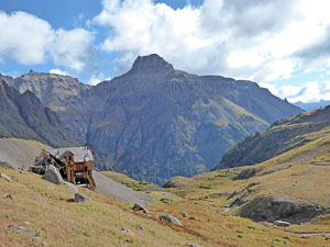
Beyond the creek the road climbs gradually to a “Y” intersection. The spur road branching right leads to a tailings pile near the dilapidated wood dormitory of the Mountain Top Mine at 2.9 miles. A gated mine tunnel, rail tracks, a metal building and various piles of debris are located atop the tailings pile. For many parties the Mountain Top Mine site is a good turn around point. If so, after investigating the ruins retrace your steps to your vehicle for a 5.8 mile round-trip hike.
To the Overlook
Distance from Trailhead: 7.6 miles (round trip)
Ending/Highest Elevation: 12,800-ft.
Elevation Gain: 2,085-ft.
If you wish to continue exploring Governor Basin, return to the “Y” intersection (3.2 miles) and take the road branching left. The road now climbs on moderately steep grades. Pay attention as you climb. You will follow the road as it curves to the right, then to the left, then to the right and back again to the left. As you curve to the left for the second time watch for a green metal stake that is leaning against a rock along the right side of the road at 3.4 miles. This should be short distance beyond a small creek, which may be dry. There is supposed to be a trail here, but it is very faint and hard to find.
Turn right at the stake and head up the grassy hill, staying to the left of the creek. As you climb note the dark rock outcropping ahead. Below this feature you should soon see a faint, boot-beaten path that heads right (north) up a grassy slope. This is the route to the overlook.
Follow the trail, which becomes more obvious as you ascend steeply up the hillside. To the southeast are fine views of Peak 13,337 towering above the Virginus mine and the San Sophia Ridge.
Reach a grassy ridge at 3.7 miles. Here the route makes a sharp left. There should be another stake marking this turn. Be sure to look around and identify some landmarks so that you don’t miss the turn on the return trip. From this vantage point Cirque and Teakettle Mountains rise beyond the ridge.
Continue climbing, stay to the left of a gully. As you crest a low rise the grade briefly abates. Ahead, on the right, is a small tailing pile. Follow the boot beaten path that crosses a small creek and ascends past the tailings pile. You are now on an obvious road that heads southwest towards the San Sophia Ridge.
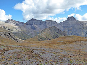
At 3.8 miles the boot beaten path turns right (north/northwest), paralleling the San Sophia Ridge as it climbs up meadows and then rocky slopes. Intermittent cairns mark the route. At 4.0 miles reach a saddle at the base of a scree slope spilling down the ridge. Turn right here and ascend a short distance to an overlook atop a bench with breathtaking views of Mount Emma, the San Sophia Ridge, Cirque Mountain, Teakettle Mountain, Potosi Peak and beyond. Mendoza Peak (13,275-ft.) and Peak 13337 punctuate the ridge rimming the south side of Governor Basin. Stony Mountain, dwarfed by the surrounding peaks, rises along the ridge to the northwest.
Hikers with the time, energy and good weather may want to continue heading north, crossing the next basin and climbing to a pass on the ridge to the left (west) of Peak 13027. From the saddle near the overlook, this side trip descends slightly and then ascends through tundra and scree covered slopes to the pass. Here views open to Mount Sneffels towering above Yankee Boy Basin. Extending the hike to the pass adds about a mile to the trip.
Beyond the pass a faint path diagonals across loose, unstable scree, heading for the ridge crest. Unfortunately the trail peters out before reaching its destination. Seasoned scramblers will now chart their own course, heading slightly left to reach a spot atop the ridge between rock outcroppings. Views from the ridge extend down Mill Creek Basin (east of Telluride) to Deep Creek Mesa and the high peaks of the Lizard Head Wilderness.
Whatever your destination, when you are done enjoying the views retrace your steps back to the trailhead. As you descend on the road, listen for jeeps coming up the road. It is hard to see around some of the curves. Step off the road to allow approaching vehicles adequate room to negotiate the narrow rugged track.
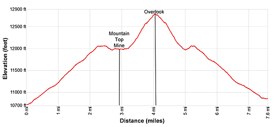
Elevation Profile
| Buy the BookThis opinionated guide includes all the hikes in the Ouray, Telluride, Silverton and Lake City sections of the website plus info on local services and nearby attractions. |

Driving Directions
Driving Directions from Ouray: From the center of Ouray (6th Avenue and Main Street), head south on Highway 550-S for 0.6 miles. At the south end of town the road climbs a switchback. As you round the hairpin curve on the first switchback watch for a signed road off to the right. This is County Road 361 leading to Camp Bird Mine and Yankee Boy Basin.
Turn right onto County Road 361 and follow the road for 4.7 miles to the large Camp Bird Mine complex. Bear slightly right to stay on the main road marked for Yankee Boy Basin and Imogen Pass. You will now drive past the mine and under a rock overhang. In 1.3 mile reach the junction with the Imogene Pass road on the left. Continue straight ahead, passing the old Sneffels town site, the Revenue Mine and the large ruins of the Atlas Mill (all on the left). Drive 0.8-miles to a “Y” intersection and bear left on the signed road for Governor Basin. (The continuation of the Yankee Boy Basin road to the right is marked for high clearance/4WD vehicles).
A short distance down the Governor Basin road is a pullout on the left. I recommend parking here.
You can drive further up the dirt Governor Basin road if you have a high clearance/4WD vehicle. To continue, follow the road as it curves to the left past the Walker/Ruby mine and then crosses Sneffels Creek on a wood bridge. Beyond the bridge continue along the main road to a “Y” intersection. Ignore the road branching right with the locked gate. Instead bear left on the main road. Beyond this junction the road crosses a creek (watch you don’t scrape your under carriage here) and becomes narrower and bumpier. There are potential places to park at 1.1, 1.4, 1.7 and 2.2 miles. Just make sure you are well off the road when you park. Adjust the hiking description above to account for the distance you drive up the road beyond the recommended parking area.
The Yankee Boy Basin road is a graded dirt road and typically passible for vehicles with reasonable clearance. As you drive up the road it gets rougher. Passenger vehicles with good clearance can typically make it to the Imogene Pass turnoff and, if driven carefully, the 0.8 miles beyond to the Governor Basin Road. Beyond this point is for high clearance/4WD vehicles only. Before setting out stop at the Ouray Visitor Center to check on current road conditions.
Trail Resources
Trail Intro / Trail Photo Gallery / Trail Map
Basecamp(s) Information:
Ouray
Region Information:
Southwest Colorado
Other Hiking Regions in:
Colorado