Details: Franklin Lakes 
Distance: 12.0 miles (round trip)
Sequoia-Kings Canyon National Park, near Mineral King in California's Southwestern Sierra
Hike Facts
- Distance: 12.0 miles (round trip)
- Elevation: 7,790-ft. - 10,488-ft.
- Elevation Gain: 2,698-ft.
- Difficulty: moderate-strenuous
- Trail Highlights: See Trail Intro
- Basecamp(s): Mineral King
- Region: California's Southwestern Sierra
This popular day hike climbs to Lower Franklin Lake, nestled in a scenic basin beneath the Great Western Divide.
Franklin Lakes
To find the trailhead from the Eagle / Mosquito parking area at the end of the Mineral King road, walk back down the road and cross the bridge over the river. A short distance beyond the bridge you will see a dirt road on the right (just over 0.1 miles from the parking area). Turn right on the dirt road and follow it up valley past the Mineral King Pack Station (on your left) to the trailhead bulletin board for Franklin Lakes and Farewell Gap.
Follow the broad Farewell Gap trail as it heads south, up the east side of the gorgeous East Fork Kaweah River valley on easy grades. A profusion of willows grow along the river banks and in the marshy areas of the meadows lining the valley floor. Copses of red firs interspersed with junipers cling to the steep slopes above the trail. Grasses and sagebrush sprinkled with wildflowers grow along the trail. Vandever Mountain (11,947-ft.) and Farewell Gap, the saddle to the east of the peak, frame the head of the valley.
At 0.6 miles a trail sign indicates that it is 5.4 miles to Franklin Lakes, 8.1 miles to Franklin Pass and 6.2 miles to Farewell Gap. A half mile past the sign Crystal Creeks cascades down the hillside and across the trail. Depending on the water levels you will either need to wade or rock-hop across the stream.
A short distance beyond the creek crossing the trail splits. A faint broad track veers right (south) into the meadow. Continue on the mail trail, which branches to the left (southeast) and ascends along the hillside on moderately steep grades.
At 1.9 miles the trail rounds a corner and arrives at Franklin Creek. A picturesque waterfall on the creek tumbles down a rocky cleft in the hillside above the trail. Crossing the creek can be problematic early in the season. Otherwise ford the creek or hop across on strategically placed rocks. The shaded area around the waterfall is a good place to take a rest before tackling the steep climb ahead.
Past the creek crossing the trail climbs an open hillside on steep switchbacks. The lower sections of the switchbacks enjoy nice views of Franklin Creek cascading down a rocky gully. As you climb be sure to turn around for vistas extending north, back down the valley.
At 2.8 miles the switchbacks end and the trail traverses along the east slopes of Farewell Canyon high above Franklin Creek. To the west mineral stained peaks in hues of brown and orange rise above emerald green meadows. Farewell Gap sits at the base of a “V-shaped” saddle at the head of the valley, flanked by Vandever Mountain to the west.
A series of switchback, starting at 3.25 miles, facilitate the climb up the valley’s eastern slope, passing through meadows sprinkled with wildflowers. At the top of the switchbacks the trail swings to the left (northeast) and arrives at the signed junction with the Franklin Lakes Trail at 3.8 miles. The trail to Farewell Gap splits off to the right (southeast) while the trail to Franklin Lakes heads left (northeast), continuing its stiff ascent of the hillside.
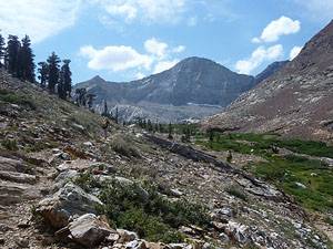
Follow the trail as it traverses northeast across rocky meadows scattered with mature foxtail pines and junipers. At 4.2 miles the trail crosses a ridge into the Franklin Creek drainage and continues its climb high above the south side of Franklin Creek. Views open to the multi-hued rocks covering the hillsides.
At 4.7 miles the trail curves north as it crosses a scree slope and then drops down to a small meadow where it rock-hops across Franklin Creek (4.8 miles). On the other side of the creek the trail climbs a rocky slope on switchbacks, passing below the Lady Franklin Mine, and then turns southeast, traversing the hillside above the north side of the creek. This section of the trail is quite scenic with mineral stained slopes in tints ranging from orange to brown rising above both sides of the valley.
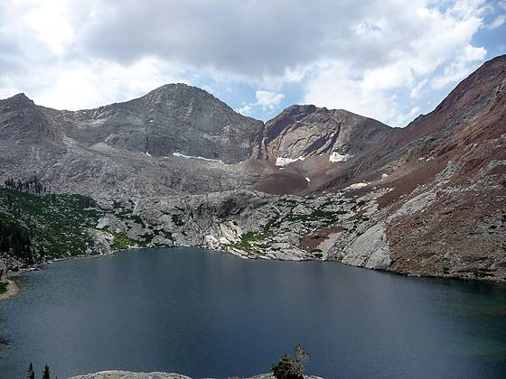
As you ascend views open to Florence Peak (12,432-ft.) and the ridges defining the Great Western Divide at the head of the valley. At 5.6 miles pass a turnoff to a camping area, located below the dam at the northwest end of the lower Franklin Lake. Just beyond the turnoff the trail climbs above the dam on long switchbacks and then traverses the hillside above the northeast side of the lake. Soon you will see rock ledges, to the south of the trail, with panoramic views overlooking Lower Franklin Lake (10,331-ft.), 6 miles from the trailhead. The ledges make a great picnic spot and good turnaround point for day hikers.
The Franklin Lakes are tucked in a rugged basin surrounded by a photogenic cirque. Towering above the basin are the imposing peaks and ridges of the Great Western Divide, anchored by Rainbow Mountain to the east and Florence Peak to the south. The red, brown and orange metamorphic rock of Tulare Peak and it associated ridges, rising along the west side of the cirque provides a striking contrast to the granite rock peaks to the south and east.
Upper Franklin Lake (10,578-ft.), reached by an off trail route, is located beyond the bench at the south end of the Lower Lake. Franklin Pass (11,760-ft.) is situated on the high ridge 1.9 miles to the southeast of the lake and is best visited as part of a multi-day backpacking trip.
After enjoying the view retrace your steps to the trailhead.
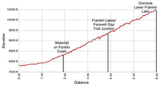
Elevation Profile
Driving Directions
From Visalia: Follow Highway 198 East for 31.5 miles to the Mineral King Road. (There is a small green sign by the road that read “Mineral King 25 miles”.) Turn right onto the Mineral King Road and follow the narrow, winding road for 23.5 miles to the Eagle/Mosquito parking lot at the end of the road. Walk back on the road, crossing the bridge over the river and look for a dirt road on the right (just over 0.1 miles from the parking area). Turn right on the dirt road and follow it up valley past the Mineral King Pack Station (on your left) to the trailhead bulletin board for Franklin Lakes and Farewell Gap.
Trail Resources
Trail Intro / Trail Photo Gallery / Trail Map
Basecamp(s) Information:
Mineral King
Region Information:
California's Southwestern Sierra
Other Hiking Regions in:
California