Backpack: Green River Lakes to Island Lake & out Elkhart Park
Segment 2: Highline Trail: Trail Creek Park to Elbow Lake Bas
Distance: 8.2 miles (one way)
Bridger Wilderness, Bridger-Teton National Forest, near Green River Lakes in Wyoming's Wind River Range
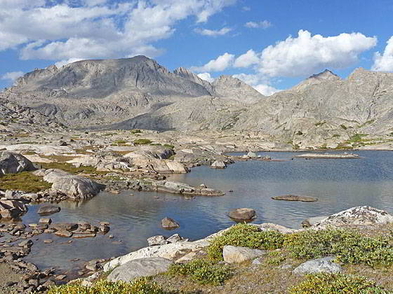
Elbow Lake
- Distance: 8.2 miles
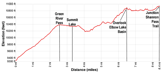
- Elevation: 0.0 miles at Trail Creek Park (9,300-ft.)
0.7 miles at Junction Shannon Pass Trail (9,640-ft.)
1.5 miles at Green River Pass (10,390-ft.)
3.25 at Junction Doubletop Mtn Trail at Summit Lake (10,330-ft.)
6.3 miles at Elbow Lake Basin Overlook (10,880-ft.)
8.2 miles at Junction Shannon Pass Trail at head of Elbow Lake Basin (10,950-ft.) - Difficulty: moderate
- Basecamp: Green River Lakes
- Region: Wyoming's Wind River Range
Highline Trail: Trail Creek Park to Elbow Lake Bas Description
This segment of the Highline Trail starts at Trail Creek Park at the signed junction of the Highline Trail with the New Fork Trail. We take the south-bound Highline Trail toward Summit Lake. (The north bound Highline heads for Green River Lakes while the New Forks Trail climbs west toward Lozier Lakes.)
Follow the Highline as it ascends through timber on moderate grades along the east side of Trail Creek. At 0.7 miles pass the junction with the Shannon Pass trail signed for Vista Pass branching left (southeast). Note: The Shannon Pass trail climbs over Vista and Cube Rock passes to Peak Lake. Beyond Peak Lake the trail crosses Shannon Pass and reconnects with the Highline at the head of the Elbow Lake basin.
After hiking a little over a mile the trail breaks from the trees and starts climbing rocky meadows scattered with trees. Here the valley narrows as it passes between the lower slopes of Glover Peak (12,068-ft.) to the west and rugged cliffs of an unnamed summit to the east. At 1.4 miles the trail crosses to the west side of the trail creek and then rock-hops back to the east side at 1.6 miles. Be sure to turn around as you travel up the valley for nice views of the high cliffs rising above the Green River valley to the north.
At 1.9 miles the trail ascends a series of switchback through clusters of spruce trees. Soon the trees give way meadows and the grade eases. Depending on the time of year you may cross a few streams trickling down the slopes above the trail. The open meadows offer fine views of Glover Peak rising to the northwest and the cliffs towering above the Green River to the north. Mt Oeneis (12,232-ft.) rises to the east.
At 2.5 miles reach Green River Pass. A few tarns lie nestled in the meadows to the west. The trail now gradually descends through lovely alpine meadows, crossing two minor creeks at 2.7 and 2.9 miles. Along the way views open to Summit Lake (10,324-ft.), a shimmering expanse of water set amid meadows and surrounded by rugged peaks.
Soon the trail begins a traverse along the western shore of Summit Lake, reaching a junction with the Doubletop Mountain Trail, signed for Palmer Lake, branching right (west) at 3.25 miles. Continue straight ahead on the Highline trail toward Trapper Lake. As you walk beside the lake enjoy views of Mt. Oeneis and Peak 12,093 rising to the east.
At 3.3 miles reach a “Y” intersection with the Trapper Lake trail branching to the right (southwest). We bear left on the Highline toward Elbow Lake. At the south end of the lake pass an unmarked junction with a trail heading left (east) along the lake’s southern shore. This trail leads to some scenic, albeit exposed, campsites above the east side of the lake.
The Highline trail now heads southeast away from the lake, climbing over a low rise and then crossing a minor stream. Here views open to the Pine Creek drainage. Follow the trail as it drops down to and crosses Pine Creek at 3.8 miles. During periods of high water wade the creek. Otherwise keep your feet dry by rock-hopping across the stream.
The trail now follows an undulating course through trees to a wood bridge spanning Elbow Creek at 4.4 miles. The creek, draining Twin Lakes, tumbles down a gully choked with boulders.
Beyond the bridge the trail climbs steeply out of the Elbow Creek drainage. The grade eases as the path breaks out of the trees, crosses a small stream and then travels through meadows set amid rocky knolls scattered with trees. Skirt the right (west) side of a tarn and then the left (east) side of a small pond hidden behind a low knoll. Ignore a faded trail branching to the right. This is an old, unmaintained path leading to the Sauerkraut Lakes.
Past the second tarn the trail curves to the left (east) and climbs over a low knoll where views open to Pass Lake (10,495-ft.) to the south. A few campsites are found above the lakeshore. At the southwest end of the lake are vestiges of the trail to the Sauerkraut Lakes.
After dropping off the knoll, rock-hop across Pass Lake’s outlet stream at 5.0 miles. Soon the trail skirts the right (south) shore of a tarn (10,455-ft.) with great views of Sky Pilot Peak (12,129-ft.) and Mt Oeneis rising to the north/northeast.
Beyond the tarn travel through meadows and then cross a rock slide a 5.4 miles. Here views open to upper Twin Lake to the north. Past the rock slide cross shin-deep Elbow Creek. Late in the season you can keep your feet dry by rock-hopping across the channel. If you are looking to camp, descend to lower Twin Lakes where you will find a few nice campsites among the Whitebark Pines.
The path now ascends a rocky trail on moderate grade to the Elbow Lake Basin, gaining over 500-ft. Initially the path curves to the left (northeast) as it climbs a rugged draw. As you gain elevation views open to Sky Pilot Peak. Soon Mt. Oeneis joins the scene. At 5.8 miles the path swings to the right (east), ascending rocky meadows and then climbing a knoll to an incredible viewpoint (10,880-ft.) overlooking the Elbow Lake Basin at 6.3 miles.
Panoramic views from the overlook include Bow Mountain (13,020-ft.), Mount Arrowhead (12,972-ft.), American Legion Peak (13,205-ft.), Henderson Peak (13,115-ft.) and the Titcomb Needles along with the high peaks rising along the Continental Divide – Mt Helen (13,620-ft.), Mt Sacagawea (13,569-ft.) and Fremont Peak (13,945-ft.) - to the east/southeast. Mount Oeneis and Sky Pilot Peak tower above the basin to the north while Stoud Peak and Mount Whitecap are seen to the northeast. Elbow Peak (11,948-ft.) dominates the view to the south. Closer at hand, small meadows grow amid ice-polished rock outcroppings and large boulders. A few stunted pines struggle to maintain a toehold amongst the rocks. Lakes and small tarns litter the magnificent basin, many unseen from this vantage point.
After admiring the views, follow the trail as it drops down from the viewpoint, skirts the right (south) side of a tarn and then heads east/northeast through the austere basin on easy grades, traversing rocky meadows, snaking around rock outcroppings and skirting large boulders. Views of the peaks slowly evolve as you move further east in the basin.
At 6.6 miles the trail crosses a stream between two tarns. Soon views open to Elbow Lake (10,777-ft.), a large, irregularly-shaped lake cradled beneath Elbow Peak. The western lakeshore is lined with ice-polished granite slabs, domes and small meadows. Rocky peninsulas jut out into the lake, creating bays. Along the eastern shore, scree slopes spill down the rugged slopes rising above the lake.
The trail now wanders above the northwestern shore, dodging rock outcroppings and small tarns nestled in rocky meadows. At 7.2 miles the trail drops down to and briefly travels north along the shoreline to the head of the lake.
The beautiful basin invites exploration. I highly recommend roaming the shoreline of Elbow Lake, taking in the evolving perspectives of the high peaks ringing the basin. A side trip to Peak Lake is also highly recommended.
On a beautiful day backpackers will be tempted to setup camp in one of the many scenic, open spots around the basin. Keep in mind that the weather changes rapidly at this elevation. If you camp be prepared for gale-force winds and ferocious thunderstorms. Pick a site protected by large boulders or rock outcroppings. Some of the best sites are located in the area above Elbow’s northwestern shore. Finding a flat spot that avoids the basin’s soggy meadows is a challenge and will take some time.
Beyond the head of the lake the trail curves to the northeast and crosses Elbow Creek at 7.5 miles. The crossing is challenging during period of high water, otherwise rock-hop across the stream. A short distance beyond the creek the path travels around small tarns, jumping a stream connecting the pools.
At 7.75 miles the paths starts ascending toward the head of the valley, climbing on easy to moderate grades to a signed junction at 8.2 miles. Here the Shannon Pass trail turns left (northwest) toward Peak Lake. We turn right on the continuation of the Highline toward the Jean Lakes (and Island Lake).
From the junction enjoy fine views of Stroud Peak rising to the east of Shannon Pass, the grassy saddle on the ridge to the northwest. Bow Mountain dominates the view to the northeast. To the south Elbow Peak and Sky Pilot Peak tower above the Elbow Lake Basin.
Return to Segment 1: Highline: Green River Lakes to Trail Creek Park
Go To Segment 3: Highline: Elbow Lake to Indian Basin Trail
Elevation Profile
Backpack Segments
- Introduction: Green River Lakes to Island Lake & out Elkhart Park
- Segment 1: Highline: Green River Lakes to Trail Creek Park
- Segment 2: Highline: Trail Creek Park to Elbow Lake
- --- Side Trip: Peak Lake
- Segment 3: Highline: Elbow Lake to Indian Basin Trail
- --- Side Trip: Island Lake Backdoor
- Segment 4: Indian Pass Trail to Island Lake
- --- Side Trip: Titcomb Basin
- --- Side Trip: Indian Basin and Pass
- --- Side Trip: Island Lake Waterfall Hike
- Segment 5: Island Lake to Elkhart Park
Driving Directions to New Fork Lakes Trailhead
Green River Lakes Trailhead: Located just off the northwest shore of scenic Green River Lake, the trailhead offers access to several trails including the Highline Trail, which is part of the Continental Divide National Scenic Trail, Clear Creek Trail, and the Roaring Fork Trail.
Directions from Pinedale: From the intersection of Pine Street (US 191) and North Tyler Ave (the Pinedale Tourism office is located on the northeast corner) in Pinedale, WY, drive west on Highway 191 (West Pine Street) for 6 miles and then turn right on WY-352 toward Cora. Follow WY-352 for 25.3 miles to the National Forest boundary, where the pavement ends. Continue straight ahead on Green River Lakes Road (Forest Service Road 600). (Stay along the east side of the river, ignoring any roads branching to the left.)
Follow Green River Lakes Road for 18.5 miles to a signed intersection for the Green River Lakes campground and trailhead. The road to the right leads to the campground. We bear slightly left, staying on the Green River Lakes Road. Continue on the road for 0.2 miles and then turn left at the signed intersection for the trailhead parking area. Drive along the spur road for 0.1 miles to a “Y” intersection and turn right into the trailhead parking area. The road to the left leads to the equestrian parking lot. The trailhead is located at the southwest end of the parking area.
The 50 mile trip should take about 1 hour and 45 minutes. Passenger cars can typically make it to the trailhead. Check at the forest service office in Pinedale for current road conditions.
Elkhart Park Trailhead: From the intersection of Pine Street (US 191) and North Tyler Ave (the Pinedale Tourism office is located on the northeast corner) in Pinedale, WY, drive east on Highway 191 (East Pine Street) for 0.3 miles and bear left onto Fremont Lake Road. Follow this road for 14.3 miles and turn right into the large parking area for the Elkhart Park/Pole Creek Trailhead. After the first 3.0 miles the road will turn into Skyline Drive/Forest Service Road 370740. The trailhead is located at the northeast end of the parking lot between the outhouse and the trailhead kiosk. It should take about 25 minutes to drive the trailhead. The last section of the road has some holes and uneven spots.
Trail Resources
- Backpack Intro
- Segment Photo Gallery
- Segment Map
- Trailhead(s) Information: Green River Lakes
- Region Information: Wyoming's Wind River Range
- Other Hiking Regions in: Wyoming