Best Hikes in Bishop, California
Location: California's Southeastern Sierra
At the junction of Highway 395 and 6, 42 miles southeast of Mammoth Lakes, CA, 200 miles south of Reno, NV, 270 miles northwest of Las Vegas, NV, 270 miles northeast of Los Angeles and 360 miles southeast of San Francisco.
By: Diane Greer
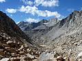
Bishop's close proximity to some of the great hikes along the eastern slopes of the spectacular Sierra Nevada Mountains makes the town a perfect base camp for outdoor enthusiasts. View Bishop Info
Introduction

Bishop (4,100-ft.) is a small, laid back town situated at the northern end of the Owens Valley along the eastern slopes of the spectacular Sierra Nevada Mountains. A variety of accommodations and services along with its close proximity to some of the regions great hikes makes the town a perfect base camp for outdoor enthusiasts.
Bishop markets itself as the small town with the big backyard and it is certain apt description. The town is surrounded by the Inyo National Forest. Bishop Creek Canyon, to the east, offers access to literally hundreds of thousands of acres of gorgeous lakes, forests and rugged mountains in the John Muir Wilderness. To the west is the huge expanse of the White Mountains, home of an ancient bristlecone pine forest. Peaks rise above 14,000-ft. on both sides of the valley.
Bishop Hiking Trails
Distance: 4.0 - 11.0 miles (Round Trip)
Difficulty: moderate-strenuous
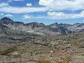
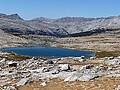
This excellent hike leads through a succession of beautiful lake basins to Bishop Pass (11,972-ft.), with spectacular views of Mount Agassiz, the Black Divide and Dusy Basin.
Distance: 6.0 - 11.8 miles (Round Trip)
Difficulty: strenuous
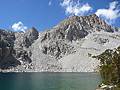
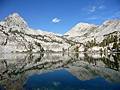
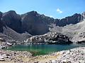
This is one of the best hikes in the Bishop area, visiting a series of beautiful lakes nestled in a dramatic basin of 13,000-ft. granite peaks.
Distance: 4.2 - 7.7 miles (Round Trip)
Difficulty: easy-moderate
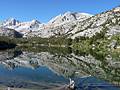
A wonderful hike visiting a series of scenic lakes nestled in a gorgeous valley surrounded by 13,000-ft peaks. Side trips lead to Morgan and Mono Passes along with a number of other lakes.
Distance: 9.6 miles (Round Trip)
Difficulty: strenuous
The scenic hike to Kearsarge Pass (11,823-ft.) travels by five shimmering lakes and features great views of the rugged crags and peaks along the east side of the Sierra Crest. From the pass breathtaking views encompass the Kearsarge Lakes, the Kearsarge Pinnacles and the Kings-Kern Divide.
Distance: 7.0 - 9.6 miles (Round Trip)
Difficulty: moderate-strenuous
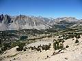
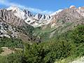
This great hike to scenic Piute Pass ascends beneath the multi-hued Piute Crags to a beautiful lakes basin tucked beneath Mt. Emerson and Peak 12691. The trail is popular with day hikers and backpackers on multi-day trips to Humphreys Basin, Evolution Valley and beyond.
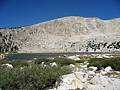
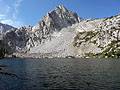
McGee Creek to Steelhead and Big McGee Lakes ![]()
Distance: 11.6 - 13.6 miles (Round Trip)
Difficulty: strenuous
This long, interesting day hike traverses the beautiful McGee Creek Valley, traveling beneath colorful peaks to two great destinations, Steelhead Lake (10,350-ft.) and Big McGee Lake (10,600-ft.).
Distance: 4.4 - 5.8 miles (Round Trip)
Difficulty: strenuous
A short, steep hike to two scenic lakes cradled in granite bowls and surrounded by rugged cliffs and photogenic peaks.
Distance: 11.6 - 12.4 miles (Round Trip)
Difficulty: moderate
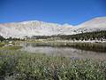
This popular hike visits a series of scenic lakes set amid pretty meadows and framed by a wall of granite peaks and ridges, anchored by Mt Langley.
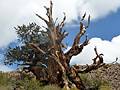
Ancient Bristlecone Pine Trails at Schulman Grove ![]()
Distance: 1.0 - 4.2 miles (Loop)
Difficulty: easy-moderate
Hike among some of the oldest trees in the world on two interesting trails that traverse the Ancient Bristlecone Pine forest at Schulman Grove, high atop of the White Mountains.
Distance: 7.0 - 8.5 miles (Round Trip)
Difficulty: strenuous
This stiff climb to Mono Pass features fine views of the Little Lakes Basin, Ruby Lake, the Mono Recesses and Pioneer Basin.
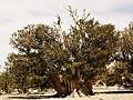
Ancient Bristlecone Pines at the Patriarch Grove ![]()
Distance: 0.3 - 0.8 miles (Round Trip)
Difficulty: easy
Visit the world's largest Bristlecone Pine, the Patriarch Tree, in the Patriarch Grove high atop the White Mountains of Inyo National Forest. Two short, scenic trails traverse the grove visiting these amazing ancient trees.
Distance: 9.6 miles (Round Trip)
Difficulty: moderate-strenuous
The hike to Tamarack Lakes provides an opportunity to get off the beaten path in the popular Rock Creek drainage. The trail traverses a series of low ridges along the south side of a broad valley before climbing the East Fork of Rock Creek to a stark lakes basin in a rugged cirque.
Cottonwood Pass & Chicken Spring Lake ![]()
Distance: 7.4 - 9.0 miles (Round Trip)
Difficulty: moderate
Fine views of Horseshoe Meadows and the Great Western Divide greet hikers at the top of Cottonwood Pass. Scenic Chicken Spring Lake is less than a mile beyond and makes for a nice day hike or first night destination for backpacking trips into Sequoia-Kings Canyon National Park.
Distance: 5.4 - 8.2 miles (Round Trip)
Difficulty: moderate-strenuous
The Treasure Lakes trail travels to a beautiful, less visited granite lakes basin surrounded by talus slopes at the foot of Mount Thompson, Mount Goode and Hurd Peak.
View Hikes by Area:
California's Southeastern SierraLee ViningMammoth LakesBishopLone PineBridgeport
Around Town

Bishop got its start as an agricultural community, providing meat and produce to the prospectors and miners attracted by the ore deposits in the Eastern Sierra and western Nevada. In the early 1900’s the City of Los Angeles started acquiring water right and property in the Owens Valley to provide water for its rapidly expanding population. By 1928 the City of Los Angeles Department of Water and Power own 90 percent of the water and much of the valley floor, severely limiting the amount of private land available for development and population growth.
Today tourism, recreation and government are among the mainstays of the Bishop economy. Visitors flock to Bishop during the summer to enjoy the great hiking, climbing, biking and fishing. The steady stream of tourists helps support a good selection of restaurants along with a range of accommodations.
Many of the town’s hotels, motels and restaurants are located along Main Street / Highway 395, making it easy to walk to dinner or stroll along the town’s streets in the late afternoon after spending the day in the mountains. One of my favorite stops in town is the Mountain Light Gallery at 106 S. Main Street. The gallery showcases the best images of Galen Rowell, a renown wilderness photographer and climber, tragically killed in an airplane crash in 2002. His images focus on the High Sierra and Eastern Sierra as well as locations around the world.
Another interesting spot near town is the 11-acres Laws Railroad Museum at the site of the former Laws Railroad Station, which ceased operation in 1959. By the time the railroad shutdown the small town around the station had disappeared. In the intervening years the museum has moved to the site and preserved historic building from around the area doomed for destruction, recreating the small village. Each type of building houses a collection of related area artifacts. There is also a rail yard, restored trains, an old turn table and extensive mining exhibits. Reach the museum by taking Highway 6 north for 4.5 miles and turning right on Silver Canyon Road.
To the east of Bishop is the Owens River. From the south end of town take any number of roads heading east for about two miles to reach the river, which is stocked with trout. Favorite activities along the river include fishing, birding, wildlife viewing and photography. Dirt roads paralleling the river provide fishing access. Talk to the people at the Bishop Visitor Center for more information.
Nearby Attractions
When you are looking for an easy day or a break from hiking in the Sierras, a trip to the Ancient Bristlecone Pine forest is a great option. Bristlecone Pines are among the oldest living trees on earth. Two bristlecone pine groves, the Shulman Grove and the Patriarch Grove, are located high atop the White Mountains, 15 miles to the east of Bishop. Four hiking trails ranging from 0.25 miles to 4.2 miles traverse these amazing groves, taking you past bristlecone pines of all shapes, sizes and ages, some over 4,000 year old. For more information and driving directions see the hiking guides to the Schulman Grove and the Patriarch Grove.
There is quite a bit to see and do around Mammoth Lakes, located 36.5 miles north of Bishop. The Lakes Basin is a great place to fish, canoe and kayak, picnic or just laze the day away beside one of the many lakes. A visit to Devil’s Postpile National Monument and Rainbow Falls is another great option. The Monument preserves a unique geological formation formed less than 100,000 years ago when cooling lava flows cracked into multi-sided vertical basalt columns. An easy 0.4 mile interpretive trail leads to the formation. Another short trail climbs to the top of the formation. While in the area you can also take an easy 5 miles round trip hike to Rainbow Falls, a 101-ft. waterfall on the San Joaquin River.
More interesting geology is located just south of Mammoth Lakes at the Hot Creek Geological site. Here bubbling hot springs, fumaroles and geysers create colorful formation along the creek. Be sure to check out the Hot Creek Fish Hatchery on the way back from the geological site. Getting to Mammoth Lakes is easy. Drive north on Highway 395 for 36.5 miles and take the exit marked for Mammoth Lakes / CA 203. Take a look at the hikingwalking.com Mammoth Lake Base Camp page for a list of all the recommended attraction along with driving directions.
A nice half day can be spent exploring Mono Lake, an ancient saline lake covering over 70 square miles and supporting a unique ecosystems, located 62 miles north of Bishop on Highway 395. The lake is home to trillons of brine shrimp and a large population of gulls. Each year millions of migratory birds visit the lake. Several roads lead to sections of the lakes shore where you can see the weird and wonderful limestone formations called tufa towers rising above the lake and swim in the salty water. Be sure to drop in at the Mono Basin Scenic Area Visitor Center, located to the south of the lake along Highway 395, to see the exhibits and learn about the ecosystem.
Yosemite National Park is a popular day trip from Bishop. To reach the park, follow Highway 395 north for 64 miles and turn left (west) on the Tioga Pass Road / Highway 120. Highway 120 travels over Tioga Pass and through the park, passing Tuolumne Meadows 18 miles past the intersection.
Another interesting diversion is a trip to the Eastern California Museum, located in Independence, 42 miles south of Bishop on Highway 395. The museum houses a great collection of artifacts and photographs documenting the cultural and natural history of Inyo County and the Eastern Sierras from Death Valley to Mono Lake. To reach the museum turn west on Center Street for 6 blocks (0.2 miles) and then turn right onto Grant Street. The museum is located at 155 N Grant.
Just to the south of Independence is the Manzanar Relocation Center, a detention camp where over 10,000 Japanese immigrants were interned during the 1940’s after the bombing of Pearl Harbor brought American into World War II. Visitor facilities include extensive exhibits, a reconstructed barracks and a 3.2 mile auto tour along which you can see remnants of orchards, eleven recently excavated rock gardens and ponds, building foundations, and the camp cemetery. The National Historic Site, located 47 miles south of Bishop on Highway 395.
Food, Lodging and Services
Just about all the basic services you need are found along Main Street / Highway 395 and the adjacent blocks. The Bishop Visitor Center is located at 690 North Main Street, at the north end of the City Park.
Accommodations, mostly consisting of hotels and motels, are primarily located along Main Street. There are a number of private campgrounds and cabins located in/around town and along the Bishop Creek Road. National Forest Service public campgrounds are located along the Bishop Creek Drainage, Rock Creek and Crowley Lakes (25 miles north of Bishop) and Big Pine Creek (located along the Glacier Lodge Road to the West of Big Pine, which is 15 miles south of Bishop).
For such a small town Bishop has a good selection of restaurants to fit everyone’s budget along with a large Vons, a grocery store located at 1190 N Main St. near the junction of Highway 396 and Highway 6. Coffee and internet fixes along with backed goods are available at the Looney Bean at 399 N Main Street and the Black Sheep Espresso Bar, at 232 N Main St.
Sage to Summit, 312 N Main Street and Wilson’s Eastside Sports, 224 N Main Street, stock clothing and gear for climbers and hikers. Fishermen should checkout Mac’s Outdoor Sports, 425 N Main St.
Spellbinder Bookstore, 124 S. Main Street, stocks a good selection of reading material and local books and maps. For hikers in need of clean clothes, the Wash Tub coin-op laundromat is located at 236 N Warren Street.