Best Hikes in Lone Pine, California
Location: California's Southeastern Sierra
On Highway 395, 210 miles north of Los Angeles and 450 miles southeast of San Francisco, 260 miles south of Reno, NV, 220 miles northwest of Las Vegas, NV.
By: Diane Greer
Lone Pine offers easy access to Mount Whitney, Horseshoe Meadows, Onion Valley and other nearby trailheads in the Golden Trout and John Muir Wilderness areas leading to the Sequoia-Kings Canyon backcountry and the Pacific Crest Trail. View Lone Pine Info
Introduction
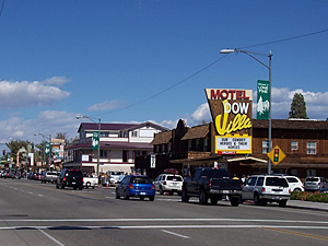
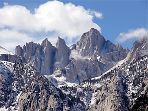
Lone Pine (3,727-ft) is a small western town in the arid Owens Valley flanked to the west by a wall of jagged granite peaks along the Sierra Crest, anchored by Mount Whitney (14,496-ft.). The annual influx of hikers and climbers seeking to summit Whitney helps support a reasonable selection of accommodations, including hotels, motels and campgrounds, restaurants and visitor services around town.
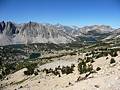
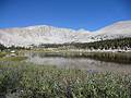
To the north and south of Whitney, roads climb to Horseshoe Meadows, Onion Valley and other trailheads high in the mountains, providing access to beautiful alpine lakes and windswept passes with stunning panoramic views. Many miles of trails traverse this high country, traveling through the Golden Trout and John Muir Wilderness areas and leading to the Sequoia-Kings Canyon backcountry and the Pacific Crest Trail.
Lone Pine Hiking Trails
Distance: 9.6 miles (Round Trip)
Difficulty: strenuous
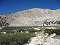
The scenic hike to Kearsarge Pass (11,823-ft.) travels by five shimmering lakes and features great views of the rugged crags and peaks along the east side of the Sierra Crest. From the pass breathtaking views encompass the Kearsarge Lakes, the Kearsarge Pinnacles and the Kings-Kern Divide.
Distance: 11.6 - 12.4 miles (Round Trip)
Difficulty: moderate
This popular hike visits a series of scenic lakes set amid pretty meadows and framed by a wall of granite peaks and ridges, anchored by Mt Langley.
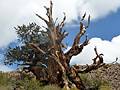
Ancient Bristlecone Pine Trails at Schulman Grove ![]()
Distance: 1.0 - 4.2 miles (Loop)
Difficulty: easy-moderate
Hike among some of the oldest trees in the world on two interesting trails that traverse the Ancient Bristlecone Pine forest at Schulman Grove, high atop of the White Mountains.
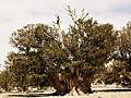
Ancient Bristlecone Pines at the Patriarch Grove ![]()
Distance: 0.3 - 0.8 miles (Round Trip)
Difficulty: easy
Visit the world's largest Bristlecone Pine, the Patriarch Tree, in the Patriarch Grove high atop the White Mountains of Inyo National Forest. Two short, scenic trails traverse the grove visiting these amazing ancient trees.
Cottonwood Pass & Chicken Spring Lake ![]()
Distance: 7.4 - 9.0 miles (Round Trip)
Difficulty: moderate
Fine views of Horseshoe Meadows and the Great Western Divide greet hikers at the top of Cottonwood Pass. Scenic Chicken Spring Lake is less than a mile beyond and makes for a nice day hike or first night destination for backpacking trips into Sequoia-Kings Canyon National Park.
View Hikes by Area:
California's Southeastern SierraLee ViningMammoth LakesBishopLone PineBridgeport
Around Town
Settled in the 1860’s, Lone Pine originally served as a supply point for miners, ranchers and farmers. The town experienced a brush with stardom during the 1920’s when Hollywood used the nearby Alabama Hills as a backdrop for westerns and war films.
While the area is still used for TV, film and commercial shoots, the main attraction in Lone Pine is the outdoors. The town is the base camp for climbers and hikers on their way to Mount Whitney (14,496-ft.), the highest point in the continental United States. The town is also a jumping off point for trips to the lowest point in the country, Death Valley National Park, located 100 miles to the west.
The first stop for anyone coming into the area is the Eastern Sierra Interagency Visitor Center, located at the junction of Highway 395 and State Route 136, one mile south of town. The facility is operated by the state, local government and federal agencies, such as the U.S. Forest Service, and provides a plethora of information on what to see and do in the eastern sierras and northern Mojave Desert.
The Lone Pine Chamber of Commerce, at 120 South Main Street (aka Highway 395), is another great source of information and literature on accommodations, restaurants, local services and nearby attractions. While visiting the chamber be sure to visit the Movie Room. The room contains photos and identifies the location for movies, such as the Lone Ranger, Gunga Din and the Charge of the Light Brigade, shot in the Alabama Hills.
Film buffs will want to visit the Lone Pine Film History Museum at 701 South Main Street. The museum features an extensive collection of costumes, cars, props, posters and other memorabilia that tells the story of filming in and around the Lone Pine area.
Certainly one of the most visited places around town is the Alabama Hills, home to weird and wonderful orange-colored metamorphic rock formations set amid a backdrop of Mount Whitney and Lone Pine Peak. Over time the elements have chiseled some of these massive boulders into impressive arches and a countless variety of strange shapes.
The Mobius Arch is probably the most photographed formation in the area. The 20-minute Mobius Arch Loop trail leads through hilly terrain to this amazing formation. To find the trail, drive through Lone Pine on Highway 395 and turn west on the Whitney Portal Road (at the traffic light). Follow the road for 2.5 miles to Movie Road. Turn right and follow the road for 1.5 miles to a "Y" intersection. Bear right and pull into a dirt parking lot immediately on your left.
Nearby Attractions
Just to the north of town is the Manzanar Relocation Center, a detention camp where over 10,000 Japanese immigrants were interned during the 1940’s after the bombing of Pearl Harbor brought American into World War II. Visitor facilities include extensive exhibits, a reconstructed barracks and a 3.2 mile auto tour along which you can see remnants of orchards, eleven recently excavated rock gardens and ponds, building foundations, and the camp cemetery. The National Historic Site, located 9.8 miles north of Lone Pine on Highway 395.
A little further north in the town of Independence is the Eastern California Museum, located in Independence. The museum houses a great collection of artifacts and photographs documenting the cultural and natural history of Inyo County and the Eastern Sierras from Death Valley to Mono Lake. To reach the museum drive north on Highway 395 for 15.6 miles and turn left (west) on Center Street. Travel along Center Street for 6 blocks (0.2 miles) and turn right onto Grant Street. The museum is located at 155 N Grant.
If you are looking for an easy day or a break from hiking in the Sierra Nevada Mountains, a trip to the Ancient Bristlecone Pine forest is a great option. Bristlecone Pines are among the oldest living trees on earth. Two bristlecone pine groves, the Shulman Grove and the Patriarch Grove, are located high atop the White Mountains, 65 miles to the north of Lone Pine. Four hiking trails ranging from 0.25 miles to 4.2 miles traverse these amazing groves, taking you past bristlecone pines of all shapes, sizes and ages, some over 4,000 year old. For more information and driving directions see the hiking guides to the Schulman Grove and the Patriarch Grove.
Food, Lodging and Services
Given its size, there is a reasonable good selection of hotels, motels and RV parks in Lone Pine. US Forest Service campgrounds are located at Whitney Portal, in Horseshoe Meadows and the Onion Valley.
There are about a dozen restaurants in town geared to fill the stomachs of hungry hikers and climber along with a small grocery store, Joseph’s Bi-Rite Market, at 119 South Main Street. Good coffee is available at the Lone Star Bistro, at 107 N Main St.
Elevation Sierra Essentials, at 150 S Main St and Lone Pine Sporting Goods at 220 S Main are the places to go if you need mountaineering, hiking or fishing gear.