Best Hikes in Telluride, Colorado
Location: Southwest Colorado
On Highway 145, 67 miles southwest of Montrose, CO, and 75 miles northeast of Cortez, CO.
By: Diane Greer
Telluride is tucked at the head of a stunning box canyon and surrounded by nearly vertical sandstone walls and peaks rising over 13,000-ft. The Mount Sneffels Wilderness is situated just north of town while the Lizard Head Wilderness is located to the southwest. View Telluride Info
Introduction
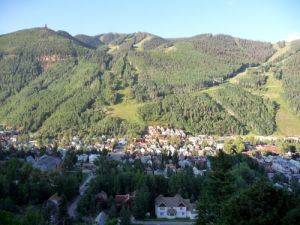
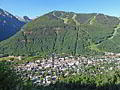
Telluride (8,745-ft), Ouray’s larger and classier neighbor, is tucked at the head of a stunning box canyon and surrounded by nearly vertical sandstone walls and peaks rising over 13,000-ft. Like Ouray, the town started as a mining camp in the late 1800’s. At the turn of the century and the height of the mining boom the town had almost 5,000 residents and more millionaires per capita than New York City.
By the mid 1950’s the boom had turned to bust with most of the mines shuttered and its residents gone. The opening of the Telluride Ski Resort in 1972 changed the town’s fortunes. White gold, in the form of snow, transformed the town into a world-class ski resort with a full complement of accommodations, restaurants and retail establishments.
Thankfully the town planners opted to preserve the Victorian charm of the town center, now listed as a National Historic District. An expanded ski area and modern mountain village was built close to Telluride but hidden from view by a 9,000-ft. ridge. The town and the mountain village are linked by a free gondola.
Telluride Hiking Trails
Distance: 8.0 - 12.7 miles (Loop)
Difficulty: strenuous
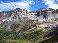
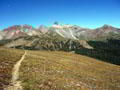
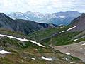
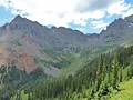
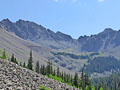
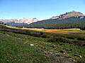
This is my favorite hike in Telluride. The trail crosses a high saddle separating two gorgeous alpine basins, traverses meadows filled with thigh-high wildflowers and serves up spectacular views of the high peaks surrounding the Telluride Valley and the San Miguel Mountains in the Lizard Head Wilderness.
Distance: 8.0 - 8.8 miles (Round Trip)
Difficulty: moderate-strenuous
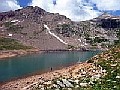
This scenic hike winds up Bridal Veil Basin past the historic Lewis Mill to Lewis Lake, nestled in a stark glacial basin at 12,700-ft. Along the way pass remnants of the area’s rich mining history, numerous waterfalls and hillsides filled with spectacular wildflowers displays.
Distance: 7.6 - 11.7 miles (Loop)
Difficulty: strenuous
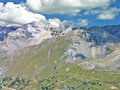
One of the top hikes in the Telluride area, this scenic loop traverses the panoramic spine of Blackface Mountain on its way to the base of Lizard Head Peak (13,113-ft.), an eroded 400-ft. tall spire shaped like the gaping maw of a lizard with its face to the sky.
Distance: 12.3 miles (Round Trip)
Difficulty: strenuous
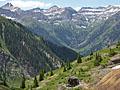
Dramatic views of Bear Creek Canyon, beautiful alpine basins, wildflowers and waterfalls are a few of the delights on this steep trail to visit the saddle (13,050-ft.) on the divide between Bear Creek and Bridal Veil basins. The hike includes an initial 2.0-mile segment of the popular Bear Creek Falls trail.
Distance: 5.6 miles (Round Trip)
Difficulty: strenuous
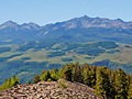
Stunning, birds-eye-views of the high peaks of the Telluride area are the reward for hikers making the steep climb to the summit of Ajax Peak.
Distance: 4.5 - 5.9 miles (Round Trip)
Difficulty: moderate
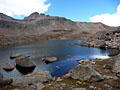
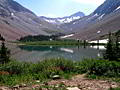
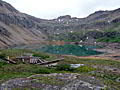
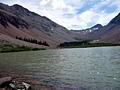
This popular hike to a high alpine lake surround by 13,000-ft. peaks offers panoramic views of the Wilson Range and the high peaks in the Lizard Head Wilderness.
Distance: 9.2 miles (Round Trip)
Difficulty: moderate-strenuous
This popular hike climbs through forest and meadows to a stark alpine lake basin surrounded by high peaks in the Lizard Head Wilderness.
Distance: 6.0 - 7.6 miles (Round Trip)
Difficulty: strenuous
Waterfalls, wildflowers and stunning views are the rewards for hikers making the stiff climb up Swamp Canyon to a high bench nestled below Ulysses S. Grant Peak. Extend the hike to Grant-Swamp Pass for breathtaking views of the Ice Lake area.
Distance: 5.5 - 8.4 miles (Loop)
Difficulty: strenuous
This interesting loop hike features panoramic views of Telluride, Bear Creek Canyon and the distant peaks of the Lizard Head Wilderness.
Distance: 6.0 miles (Round Trip)
Difficulty: moderate-strenuous
This nice hike up pretty Bridal Veil Basin leads past waterfalls and wildflowers to Blue Lake (12,220-ft.) nestled in a glacial cirque littered with mining relics.
Distance: 4.9 - 5.0 miles (Loop)
Difficulty: moderate-strenuous
Trail Closed This scenic hike ascends a hand-laid trail to the summit of Hawn Mountain with terrific views of the Lizard Head Wilderness and the high peaks to the east and southeast of downtown Telluride.
Distance: 8.0 miles (Round Trip)
Difficulty: moderate-strenuous
Iron Mountain climbs a steep mining road with fine views of the surrounding mountains along with Wilson Peak and the Lizard Head Wilderness. Aspen groves, waterfalls and an old mine add interest to the hike.
Distance: 4.6 miles (Round Trip)
Difficulty: easy-moderate
This half day hike up Bear Creek Canyon offers scenic views of the rugged cliffs lining the canyon and ends at a pretty waterfall. It’s a nice option if you have limited time or just want an easy day.
Liberty Bell / Marshall Basin Loop ![]()
Distance: 6.0 - 10.6 miles (Loop)
Difficulty: strenuous
This lightly traveled trail climbs steeply to Liberty Bell basin and a scenic ridge. Extend the hike by descending the Marshall Basin, scattered with mining ruins, on an off trail route to the Tomboy Mine and ghost town. Complete the loop by walking the Tomboy Road back to town.
Distance: 3.2 miles (Loop)
Difficulty: moderate-strenuous
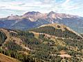
This short, steep hike features fine views of Telluride along with the ski slopes and peaks rising to along the south side of the valley. The popular trail, used by locals for exercise and dog walks, is a good option for acclimatizing or if the weather precludes hiking in the high country.
Distance: 6.6 miles (Round Trip)
Difficulty: moderate-strenuous
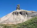
A nice hike to the base of Lizard Head Peak, a distinctive 13,113-ft. rock spire towering above Highway 145 just south of Lizard Head Pass.
Kilpacker Trail to Navajo Lake ![]()
Distance: 11.8 miles (Round Trip)
Difficulty: moderate-strenuous
This alternative route travels through forest and then joins the Navajo Lake trail, a popular hike to a pretty alpine lake basin surrounded by high peaks. The combined route involves less elevation gain then the Navajo Lake trail but is 2.6 miles (round trip) longer.
Distance: 4.0 miles (Round Trip)
Difficulty: easy-moderate
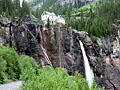
This hike ascends a jeep road and offers stunning views of Bridal Veil Falls, the tallest free falling waterfall in Colorado, the historic power plant at the top of the falls and the Telluride valley. The views are an added bonus for hikers who walk or drive up the road to reach the Bridal Veil trailhead leading to Blue Lake, Lewis Lake and other destinations in the Bridal Veil basin.
Distance: 2.3 miles (One Way)
Difficulty: easy
The 2.25-mile unmarked Railroad Grade route, linking the Cross Mountain trailhead to the Lizard Head trailhead, enables hikers to complete a great 11.7 mile loop over Black Face Mountain to the base of the Lizard Head spire in the Lizard Head Wilderness. The walk may also be of interest to people looking for a nice easy stroll from the Lizard Head Pass parking area or the Cross Mountain trailhead.
View Hikes by Area:
Southwest ColoradoOurayTellurideSilvertonLake City
| Support our Site |
Around Town
In the summer visitors flock to Telluride, drawn by the area’s natural beauty, diverse outdoor activities and festivals. Hikers can literally roll out of bed and walk to trailheads in town leading to some of the region’s best hikes. Ten miles to the southwest lies the Lizard Head Wilderness, encompassing three fourteeners and several other summits over 13,000-ft.
If you like Victorian architecture take a stroll along the town’s backstreets to see restored structures as well as recently built houses in keeping with the town’s historic character. Another nice walk is the 4.25 mile San Miguel River trail, a walking and bicycle path that meanders through town along the river past the town’s park and campground to the Pandora Mine.
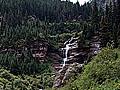
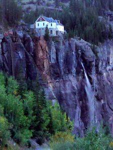
Bridal Veil Falls, the tallest freefalling waterfall in Colorado, is a favorite destination located 4 miles east of Telluride. Head east on Colorado Avenue to the parking lot just past the Pandora Mine. Follow the 4WD road or trail that switchbacks uphill for 1.2 miles to the base of the falls. This vantage point provides great views of the waterfall plunging 365-ft. from just beneath the historic Bridal Veil power plant to a stream feeding the San Miguel River. The viewpoint is often enveloped in mist from the water thundering over the rock face and hitting a small pool at the base of the falls.
You can follow the road from the remaining 0.8 miles to a gate blocking further vehicle access up the Bridal Veil Basin. This section of the road enjoys wonderful views of the steep cliffs forming the head of the Telluride valley and the town in the distance. Along the way dramatic views open to the power plant perched atop a rock ledge just above the falls. The building, restored in the 1990’s, is listed on the National Register of Historic places. For a closer view of the plant duck through the gate and follow the seldom used mining road for a few minutes to a viewpoint just above the power plant building. (The building and the area around the plant it is private property.)
A hike to the Bear Creek Falls is another popular walk. The 2.3 mile trail (one-way) starts at the south end of Pine Street and follows a good trail through the 325-acre Bear Creek Preserve to a great viewpoint showcasing the falls. Total elevation gain is just over 1,380-ft. Hikers with the time and energy can continue up the dramatic Bear Creek canyon on the Wasatch trail.
Nearby Attractions
A variety of activities are available if you want to take a day off from hiking. A short scenic drive along the San Juan Skyway on Highway 45 south of Telluride leads past Trout Lake to Lizard Head Pass (10,222-ft.) where you can enjoy views of Lizard Head’s distinctive lone spire rising 400-ft. above its rocky pedestal. Be sure to take a side trip to Trout Lake and the little mining town of Ophir along the way.
Driving north along the San Juan Skyway leads to Placerville, where the route turns right (east) on Highway 62 over Dallas Divide (8,983-ft.) to Ridgway. The drive between Dallas Divide and Ridgway offers panoramic views of the Mount Sneffels Range and the jagged ridges of the Uncompahgre Wilderness rising to the east.
Ridgway, a small town set in the beautiful Uncompahgre Valley, is home to a number of art galleries, antique stores and interesting retail establishments.
A full day needs to be allocated to drive the entire San Juan Skyway. At Ridgeway the route turns right on U.S. 550, heading south toward Ouray and Silverton. This section of the route, which features wonderful scenery littered with mining relics, climbs over 11,018-ft. Red Mountain Pass on its way to Silverton. My recommendation is to drive this route as part of an extended trip with overnight stops in Ouray and Silverton. Archaeology buffs will also want to take a side trip to Mesa Verde near Cortez, Colorado, to view the cliff dwellings.
Several 4WD roads lead to ghost towns and stunning views. The easiest is the 5-mile road to Alta Lakes and Alta Ghost town. Be sure to check at the visitor center regarding road conditions and the skill level required to navigate the roads. Mountain bikers will find plenty of trails and 4WD roads of varying lengths and difficulties.
Food, Lodging and Services
Telluride features a full complement of accommodations, restaurants and shops. The town’s main street, Colorado Avenue, and the adjacent side streets are lined with an eclectic collection of galleries, boutiques, specialty stores, restaurants and gift shops. Numerous outdoor stores such as the Jagged Edge Mountain Gear (223 E Colorado Ave) and Telluride Sports (150 W. Colorado) cater to climbers, hikers and fisherman.
Clark’s Market at 700 W Colorado and the Village Market, at 157 Fir Street, stock just about everything you need to cook the most elaborate of meals. Baked in Telluride, at 127 Fir Street, turns out delicious goodies as well as sandwiches and snacks. Caffeine addicts can get their daily fix at Coffee Cowboy at 131 E. Colorado or at High Alpine Coffee in the back of Between the Covers Bookstore, at 224 W Colorado.
The visitor center and central reservation office is located at 236 W. Colorado Avenue. Between the Covers at 224 W Colorado is the place to got for maps, guidebooks and leisure reading material.