Best Hikes in Grindelwald
Location: Bernese Oberland
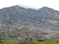
Grindelwald Hiking Trails
Distance: 10.2 miles (One Way)
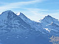
One of the best hikes in the Grindelwald area features fabulous views of the Bernese Alps stretching from the Wetterhorn, Eiger, Jungfrau and Breithorn, towering above the Grindelwald and Lauterbrunnen Valleys, to the Bluemlisalp massif in the southwest.
Distance: 10.8 miles (One Way)
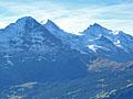
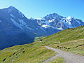
A triad of giants; the Eiger, Monch and Jungfrau, dominate the breathtaking views along this scenic hike from Mannlichen to Wengen.
Distance: 3.5 - 8.9 miles (One Way)
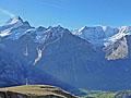
Panoramic views of the 4,000-meter peaks, glacial cirques and deep gorges to the south of Grindelwald are the highlights of this terrific hike between Grosse Scheidegg and Bussalp.
Distance: 7.2 miles (Round Trip)
Amazing views of the glacier clad peaks towering above Grindelwald and Lauterbrunnen along with views of Lake Brienz and beyond are the highlights of this popular trail climbing to the historic Faulhorn Berghaus and the summit of the Faulhorn.
Panoramaweg: Mannlichen to Kleine Scheidegg ![]()
Distance: 2.8 miles (One Way)
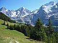
The Panoramaweg, between Mannlichen and Kleine Scheidegg, is an easy, popular hike with nonstop views the Eiger, Monch and Jungfrau. Extend the hike with a walk to the Mannlichen summit for more breathtaking views.
Distance: 3.8 miles (Round Trip)
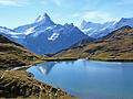
This very popular hike packs a ton of scenery into a very short distance. Nonstop views encompass Grindalwald’s iconic peaks towering above the south side of the valley. These summits form the backdrop for the Bachsee, a gorgeous lake set amid beautiful alpine meadows.
Distance: 3.5 miles (One Way)
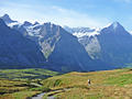
The trail between Grosse Scheidegg and First follows an undulated path through bucolic meadows with evolving, panoramic views of the massive peaks, adorn with glistening glaciers, towering above the Grindelwald Valley. Along the way waterfalls, wildflowers and small alps add interest to the hike.
Distance: 3.8 - 8.5 miles (One Way)
This interesting hike travels along the base of the Eiger with up-close and dramatic views of the iconic peak's sheer north face along with fine views of the Grindelwald Valley and nearby summits. Several options extend the hike, adding to the scenic delights of the day.
View Hikes by Area:
Bernese OberlandGrindelwaldLauterbrunnenGriesalpKanderstegEngelbergMeiringenAltdorf
| Support our Site |