Best Hikes in Buena Vista, Colorado
Location: Central Colorado
On US Highway 24, 34 miles south of Leadville, 24 miles north of Salida, 93 miles west of Colorado Springs and 122 miles southwest of Denver
By: Diane Greer
The area around Buena Vista boasts the highest concentration of summits over 14,000-ft. in Colorado and is home to the Arkansas River -- one of state’s most popular whitewater rivers, making the town a magnet for outdoor enthusiasts. View Buena Vista Info
Introduction
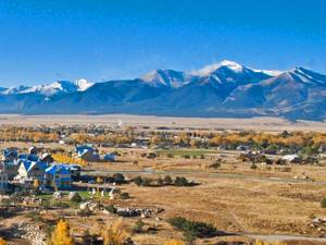
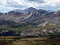
Buena Vista (7,954-ft.), which means beautiful view, truly lives up to its name. The town, between Leadville and Salida in the Upper Arkansas River valley, is surrounded by the high peaks of the San Isabel National Forest. The area boasts the highest concentration of summits over 14,000-ft. in Colorado and is home to the Arkansas River -- one of state’s most popular whitewater rivers, making the town a magnet for outdoor enthusiasts.
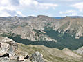
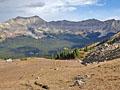
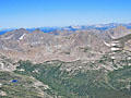
From May through Labor Day rafters and kayakers descend on the town, floating the Arkansas River on outings ranging from exciting family rafting trips to hair-raising adventures through challenging rapids. By mid-summer hordes of peak baggers come to scale the area’s 14,000-ft. summits. Hikers with less lofty goals discover glorious scenery along trails ascending beautiful valleys to shimmering alpine lakes and high passes surrounded by towering peaks in the Collegiate Peaks and Mt. Massive Wilderness areas.
Buena Vista Hiking Trails
Distance: 9.5 miles (Round Trip)
Difficulty: strenuous-difficult
Get an early start on this very steep climb to the summit of Mount Yale (14,196-ft.). Atop the mountain enjoy great views of nearby 14ers in the Sawatch Range, the Elk Mountains and the Arkansas River Valley.
Distance: 7.6 - 10.2 miles (Round Trip)
Difficulty: moderate-strenuous
The ascent of the Denny Creek valley to Brown’s pass features terrific view of the 14er’s in the Collegiate Peaks Wilderness. Extend the hike with a high traverse to a saddle overlooking the North Cottonwood Creek with more great views of the high peaks of the Sawatch Range.
Distance: 13.6 miles (Round Trip)
Difficulty: strenuous-difficult
A scenic trail with a steady ascent and short class-2 scramble leads to the summit of Mount Harvard (14,420-ft.) where hikers are greeted with stunning, panoramic views of five 14,000-ft. summits in the Collegiate Peaks and the surrounding valley.
Distance: 6.6 - 12.0 miles (Round Trip)
Difficulty: moderate
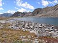
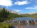
The hike to Lake Ann, cradled in a pretty alpine basin beneath the Continental Divide, features great views of Huron Peak and the Three Apostles. Continue the hike to a saddle on the divide with stunning views of the Taylor Valley and the peaks riming the Clear Creek valley.
Distance: 11.0 miles (Round Trip)
Difficulty: moderate-strenuous
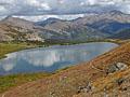
Great views of three Colorado 14ers; Mt. Harvard, Mt. Columbia and Mt. Yale, are the rewards of this hike up the scenic Horn Fork basin to Bear Lake, an alpine jewel nestled in a rugged bowl beneath the Continental Divide in the Collegiate Peaks Wilderness.
Distance: 8.1 miles (Round Trip)
Difficulty: moderate-strenuous
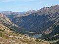
This trail travels up a beautiful, secluded valley to wind swept tarn and then a saddle on the Continental Divide overlooking the Fryingpan Lakes. The quiet valley offers good opportunities to spot wildlife and features fine views of the surrounding high peaks.
Distance: 6.2 - 6.8 miles (Round Trip)
Difficulty: moderate
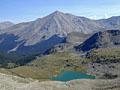
This family-friendly scenic hike climbs on moderate grades to a lovely lake with terrific views of Mount Yale (14,196-ft.) and Turner Peak to the north, the Gladstone Ridge to the east and Jones Mountains to the West.
Distance: 9.0 miles (Round Trip)
Difficulty: strenuous
The strenuous hike to Elkhead Pass, one of the highest passes in Colorado, steeply ascends scenic Missouri Gulch to a 13,220-ft. pass with panoramic views of the 13,000-ft and 14,000-ft. peaks looming above the expansive meadows of Missouri Basin.
Distance: 5.8 - 12.0 miles (Round Trip)
Difficulty: moderate-strenuous
Pretty streams, an amazing waterfall and a lovely lake set amid a beautiful basin are some of the scenic rewards of the hike to Brown’s Lake in the San Isabel National Forest.
Distance: 4.7 miles (Round Trip)
Difficulty: easy
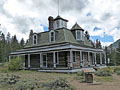
This easy hike traversing the south shore of Twin Lakes leads to Interlaken, an interesting historic site once home to a popular luxury resort during the late 1800’s. From the resort and trail along the lake enjoy fine views of Twin Lakes, Mt. Elbert (14,433-ft.) and the surrounding peaks.
View Hikes by Area:
Central ColoradoAspenBuena VistaCrested ButteLeadvilleMarble
| Support our Site |
Around Town
Buena Vista, pronounced "BEW-na Vista" by the local denizens, is a friendly, laid-back town of about 2,700-people. The town developed in the 1870’s as a supply center for miners in the Upper Arkansas Valley and ranchers that had settled along the Arkansas River. By the 1880’s construction of an ore sampling plant and smelter drew laborers to the town. Three railroads, the Denver, South Park & Pacific, the Denver & Rio Grande and the Midland ran through town, servicing mining communities to the north. Freight wagons lumbered along the town’s streets carrying ore from the nearby mining town of St. Elmo. The influx of people created a boom and for a period the town was known for its raucous saloons, gambling halls and brothels.
As with other Colorado mining communities, the demise of the mining industry resulted in a downturn. For a time in the early 1900’s the area was renowned for producing head lettuce. The lettuce boom lasted until 1948 when refrigerated railroad cars allowed West Coast lettuce growers to compete in the local markets. Today tourism, farming and ranching are the town’s mainstays.
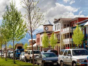
East Main Street, to the east of U.S. Highway 24, is the heart of town. Many of the buildings dating back to the late 1800’s still stand and are now restaurants, coffee shops, boutiques and other businesses. At the east end of East Main Street, next to the Arkansas River, is River Park. The park includes a playground, dog park, skate park and disc golf course. A bridge across the Arkansas River provides access to mountain biking, hiking and horseback trails along the of the Midland Trail system.
The Barbara Whipple trail, actually several interconnecting trails on the east side of the Arkansas River, is a popular place for a short walk. The trail system is accessed from the bridge cross the Arkansas River in River Park. A 1.3 miles loop travels through pinon pines along a section of the Old Midland Railroad grade. Overlooks along the trail offer terrific views of the Collegiate Peaks to the west. Kiosks along the trail offer information about the area’s history. The hike can be extended by combining segments of trail system. A map of the trail system is available at River Park.
Buena Vista’s new downtown area, called South Main, was developed in conjunction with a world-class whitewater park for kayakers along the Arkansas River. The walkable, pedestrian friendly community incorporates residential, shopping, lodging and restaurants in a compact area adjacent to the park. Kayakers can literally suit up at home, shoulder their kayaks and walk to the park.
The growing area, which features live music during the summer weekends, is becoming quite popular with visitors. A trail runs north along the Whitewater Park to the town’s River Park, creating a lovely place to watch kayaker and take a stroll in the evenings. From River Park it is an easy walk along East Main Street to the restaurants and shops in the older section of downtown. After wandering around downtown, pick a side street to loop back to South Main.
An interesting stop in town is the Buena Vista Heritage Museum, located in the old Court House at 506 East Main Street. The museum includes historic relics and exhibits explaining the town’s history along with a large model train display.
Hikers looking for a day off will find plenty of companies specializing in rafting and kayaking trips along the Arkansas River. There are also lots of opportunities to learn Stand Up Paddle boarding. If you are already a veteran of the sport, Cottonwood Lake, along CO 306 to the east of town, is a great place to paddle and enjoy the beautiful scenery. SUP veterans looking for thrills will have fun paddling through the water features in the Whitewater Park.
If you are looking for something different to do in the evening, check out what is playing at the Comanche Drive-In Theatre. While waiting for the movie to start enjoy the great views of the Collegiate Peaks. Bring cash, no credit or debit cards accepted. The drive-in is located three miles west of Buena Vista along CO 306.
Nearby Attractions
In addition to whitewater sports, there are plenty of things to do if you want to take a day off from hiking. A nice day can be spent combining a trip to Twin Lakes and Independence Pass (12,095-ft.) on the Continental Divide, one of the highest passes in the U.S. To reach Twin Lakes drive north on U.S. 24 for 19.2 miles and and turn left (west) on CO 82 W, aka the “Top of the Rockies Scenic Byway.” Follow CO 82 west for 6.3 miles along the north shore of Twin Lakes to the town of Twin Lakes, located on the north side of the highway beneath Mt. Elbert, Colorado’s highest peak. Take some time to wander the town’s back streets to see the historic buildings. You can also take a boat trip or hike to Interlaken, an historic site preserving an old resort.
When you are done visiting Twin Lakes, continue west on CO 82 to Independence Pass (23.5 miles west of the intersection with US 24). The drive features views of the surrounding mountains and forests. At the pass a short paved trail leads to an overlook with incredible panoramic views of the surrounding peaks.
Another nice destination is Cottonwood Pass (12,126-ft.). From the traffic light on East Main Street and CO 306, head west on CO 306 for 18 miles to the pass with great views of the Sawatch Range, the Collegiate Peaks and Taylor Park Reservoir. The trip can be combined with a half day hike to Ptarmigan Lake.
If you like ghost towns take a scenic drive up Chalk Creek Canyon to St. Elmo, once home to over 1,000 people during the area’s mining boom. Stroll around the site to see many of the town’s original building, which have been preserved. To reach St. Elmo drive south on US 24 for 8 miles and turn right (west) on scenic County Road 162/Chalk Creek Road at Northrop. The paved road eventually turns to gravel, reaching the town in 15.8 miles.
The ghost towns of Vicksburg and Winfield are located 9 miles and 12 miles (respectively) up the scenic Clear Creek Reservoir Road/County Road 390. At its peak in the 1880’s, the mining community of Vicksburg housed 700 people and had 40 buildings including two saloons, two billard halls, two hotels, a boarding house and a blacksmith shop. Some of the original cabins are still occupied in the summer. Winfield in 1890 boasted a population of 1,500. Both towns, maintained by the Chaffee County Historic Society, include nicely preserved structures and are listed on the National Register of Historic Places.
Fishermen and boaters might want to stop at the Clear Creek Reservoir on the way to Vicksburg and Winfield. The lake offer excellent fishing for rainbow, cutthroat and brown trout along with tiger muskies and kokanee salmon. Twin Lakes Reservoir is another great place to catch trout. The Gold Medal Waters along the Arkansas River offers great fishing for brown and rainbow trout. Cottonwood Creek along CR 306 is another favorite of local fishermen.
A trip to Salida is a good option for a rainy day. The small town, 24 miles south of Buena Vista along US 285, is home to a thriving artist community. Artist-galleries, along with restaurants and other retail venues, line the streets in the town’s historic district.
A visit to Leadville is another great choice for a rainy day. The town includes an interesting mining museum, historic houses and mine tours. See the Leadville section of this guide for more information.
Food, Lodging and Services
Buena Vista offers a good selection of accommodations, a nice variety of restaurants and the basic services required by outdoor recreationalists. You might want to start at the Buena Vista Visitor Center at 343 US Highway 24 (east side of the highway and south of E Main Street) to pick up maps and other local information.
Lodging includes hotels, motels, B&B’s, vacation rentals, cabins, RV parks and campgrounds. There are two large campgrounds in the San Isabel National Forest: the Collegiate Peaks campground, with sites reserved through recreation.gov, and the Cottonwood Lake Campground (first come, first served). Both campgrounds are located along CO 306.
Other campgrounds include sites at Chalk Creek Canyon, Chalk Creek Lake and Winfield. Nice dispersed campsites are located along the Clear Creek Reservoir Road / CR 390. See the Salida Ranger District section of the San Isabel National Forest Camping page for more information.
Restaurants, cafes and coffee shops vary from fast food joints along US Highway 24 to great local spots like the Simple Eatery at 402 E Main, House Rock Kitchen at 421 E Main and the Eddyline at 926 S Main. For a caffeine fix and breakfast I recommend the Buena Vista Roastery at 409 E Main. A nice grocery store, City Market, is located at 438 US Highway 24, on the west side of the highway south of E Main Street.
Hiking and backpacking supplies are available at The Trailhead at 402 E Main. Colorado Kayaks at 327 E Main sells and rents paddleboards, kayaks, rafts and all the accessories you need for a whitewater adventure. Fishermen in need of supplies and advice should stop at ArkAnglers at 517 South Highway 24.