Best Hikes in Mammoth Lakes, California
Location: California's Southeastern Sierra
On CA 203, 3 miles west of US Highway 395, 170 miles south of Reno, NV, 310 miles northwest of Las Vegas, NV, 310 miles north of Los Angeles and 330 miles southeast of San Francisco.
By: Diane Greer
Mammoth Lakes is surrounded by national forest lands and near the Ansel Adams and John Muir Wilderness areas, the Devil’s Postpile National Monument, beautiful McGee Creek and Rock Creek areas and eastern Yosemite National Park. View Mammoth Lakes Info
Introduction

Mammoth Lakes (7,920-ft.), a popular California ski resorts, is nestled beneath the eastern slopes of the Sierra Nevada Mountains. During the summer visitors are drawn to the area’s natural beauty, diverse outdoor activities and good selection of accommodations, restaurants and retail establishments.
The town is surrounded by national forest lands and is in close proximity to the Ansel Adams and John Muir Wilderness areas and the Devil’s Postpile National Monument. Area trails climb through mature pine forest, pass pretty lakes and wander through alpine meadows framed by stunning granite peaks. Trails crossing the Sierra Crest connect with the Pacific Crest and John Muir trails. More great hikes are located to the northeast in nearby Yosemite National Park and to the south along the McGee Creek and Rock Creek drainages.
Mammoth Lakes Hiking Trails
Distance: 7.8 - 13.4 miles (Round Trip)
Difficulty: strenuous
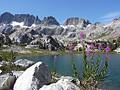
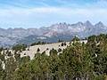
The jagged spires of the Minarets, along with Mount Ritter and Banner Peak, form the dramatic backdrop for Ediza Lake, one of the most stunning lakes in the Ritter Range. This hike visits this alpine jewel, passing beautiful Shadow Lake and a series of pretty waterfalls on Shadow Creek along the way.
Distance: 4.0 - 11.0 miles (Round Trip)
Difficulty: moderate-strenuous
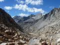
This excellent hike leads through a succession of beautiful lake basins to Bishop Pass (11,972-ft.), with spectacular views of Mount Agassiz, the Black Divide and Dusy Basin.
Distance: 6.0 - 11.8 miles (Round Trip)
Difficulty: strenuous
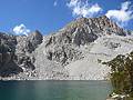
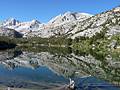
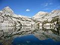
This is one of the best hikes in the Bishop area, visiting a series of beautiful lakes nestled in a dramatic basin of 13,000-ft. granite peaks.
Distance: 4.9 - 9.1 miles (Loop)
Difficulty: easy-moderate
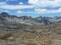
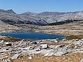
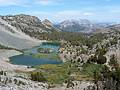
The loop around the 20 Lakes Basin travels through breathtaking alpine scenery, visiting nine stunning lakes surrounded by dramatic peaks and ridges. The glorious scenery and relative ease of the trail make this a very popular hike.
Distance: 4.2 - 7.7 miles (Round Trip)
Difficulty: easy-moderate
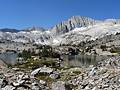
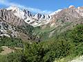
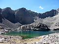
A wonderful hike visiting a series of scenic lakes nestled in a gorgeous valley surrounded by 13,000-ft peaks. Side trips lead to Morgan and Mono Passes along with a number of other lakes.
Distance: 7.0 - 9.6 miles (Round Trip)
Difficulty: moderate-strenuous
This great hike to scenic Piute Pass ascends beneath the multi-hued Piute Crags to a beautiful lakes basin tucked beneath Mt. Emerson and Peak 12691. The trail is popular with day hikers and backpackers on multi-day trips to Humphreys Basin, Evolution Valley and beyond.
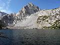
McGee Creek to Steelhead and Big McGee Lakes ![]()
Distance: 11.6 - 13.6 miles (Round Trip)
Difficulty: strenuous
This long, interesting day hike traverses the beautiful McGee Creek Valley, traveling beneath colorful peaks to two great destinations, Steelhead Lake (10,350-ft.) and Big McGee Lake (10,600-ft.).
Distance: 4.4 - 5.8 miles (Round Trip)
Difficulty: strenuous
A short, steep hike to two scenic lakes cradled in granite bowls and surrounded by rugged cliffs and photogenic peaks.
Distance: 4.4 - 13.2 miles (Loop)
Difficulty: strenuous
This scenic trail climbs along the Mammoth Crest, with fabulous views of the Mammoth Lakes, the Ritter Range and Middle Fork San Joaquin Canyon. Beyond the Crest the trail drops to scenic Deer Lakes where a route leads to the Duck Pass Trail, creating a long, interesting loop hike.
Distance: 7.0 - 8.5 miles (Round Trip)
Difficulty: strenuous
This stiff climb to Mono Pass features fine views of the Little Lakes Basin, Ruby Lake, the Mono Recesses and Pioneer Basin.
Distance: 7.2 miles (Round Trip)
Difficulty: moderate
This nice hike visits two scenic lakes and then climbs to a pass on the Pacific Crest with great views of the lakes basin. An overlook to the south of the pass provides panoramic views of Duck Lake and the Silver Divide.
Distance: 9.6 miles (Round Trip)
Difficulty: moderate-strenuous
The hike to Tamarack Lakes provides an opportunity to get off the beaten path in the popular Rock Creek drainage. The trail traverses a series of low ridges along the south side of a broad valley before climbing the East Fork of Rock Creek to a stark lakes basin in a rugged cirque.
Distance: 5.4 - 8.2 miles (Round Trip)
Difficulty: moderate-strenuous
The Treasure Lakes trail travels to a beautiful, less visited granite lakes basin surrounded by talus slopes at the foot of Mount Thompson, Mount Goode and Hurd Peak.
View Hikes by Area:
California's Southeastern SierraLee ViningMammoth LakesBishopLone PineBridgeport
Around Town

Mammoth Lakes is named after the Mammoth Lode, an 1877 gold and silver strike in the nearby Lakes Basin. The find played out in just three years and the old town sites around the mines were eventually abandoned. Current day Mammoth Lakes owes its existence to the completion of a modern highway along the eastern sierras in 1937, which facilitated access for outdoor enthusiasts seeking a summer retreat, and the subsequent development of the ski resort after World War II.
The layout of the town is in keeping with the southern California car culture. Retail establishments in strip malls are strung out along two main thoroughfares, Main Street (aka CA 203), from Old Mammoth Road to Minaret Road, and along Old Mammoth Road, from Main Street to Mammoth Creek Road. Mammoth Village, an open air mall built around a condo and hotel complex on Minaret Road, opened in 2003, includes a number of restaurants and retail shops. Condo complexes and areas with single family homes ring two large golf courses near the town center and the area to the east of the ski slopes on Mammoth Mountain (11,053-ft.).
When you get into town I strongly recommend a stop at the Mammoth Lakes Welcome Center, located at 2510 Main St, 3 miles west of Hwy 395. The center is staffed by forest service and town personnel and provides tons of helpful area information. This is also the place to obtain wilderness permits for overnight backpacking trips.
The beautiful Mammoth Lakes Basin lies in a large glacial cirque beneath rugged peaks to the southwest of town. Within the basin a four large lakes, Twin Lakes, Lake Mary, Lake George and Lake Mamie, and several smaller ones. The larger lakes are stocked with trout and offer canoeing, kayaking and boating opportunities. Swimming, picnicking and biking are other popular activities. To reach the lakes head west on Main Street/CA 203, which turns into Lake Mary Road, for 3 miles.
History buffs will enjoy a short walk to the Mammoth Consolidated Mine ruins. To reach the ruins find the Heart Lake trailhead at the southwest end of the Coldwater campground in the Lakes Basin. Follow the trail for a short distance. Soon after crossing Mammoth Creek you will see two spur trails heading left that visiting the remains of the mine, founded in 1927. The ruins include ore processing equipment, a mine adit, assayer’s office, manager’s office, cookhouse and bunk house. A self guided walking tour brochure of the mine site is available at the Mammoth Visitor’s Center.
Devil’s Postpile and Rainbow Falls are two popular destinations in the Mammoth Area. The Devil’s Postpile National Monument preserves a unique geological formation formed less than 100,000 years ago when cooling lava flows cracked into multi-sided vertical basalt columns. An easy 0.4 mile interpretive trail leads to the formation. Another short trail climbs to the top of the formation.
While in the area you can also take an easy 5 miles round trip hike to Rainbow Falls, a 101-ft. waterfall on the San Joaquin River. Another nice option is the 2.8 miles round trip stroll to cascading Minaret Falls, located just outside of the Monument.
To reach the monument and the falls requires a mandatory shuttle bus ride (fee) into the Reds Meadow Valley. Busses depart regularly from the Mammoth Mountain Adventure Center at the ski area at the end of Minaret Road. The bus runs between the ski area and Reds Meadow Resort, making stops at the Monument, campgrounds and trailheads along the valley.
Nearby Attractions
If you are need a break from hiking there are plenty of good day trips around the Mammoth area. Just south of town is the Hot Creek Geological site. A chamber of hot magma, which lies about three miles below the surface of the earth, produces bubbling hot springs, geysers and fumaroles (gas vents) that create colorful formations along Hot Creek. To reach the site head south on Highway 395 for 3 miles and turn left (northeast) on the Hot Creek Hatchery Road. Follow the road for 2.8 miles to the Geological site, located on the left side of the road.
On the way back from Hot Creek Geological site stop at the Hot Creek Fish Hatchery (1.5 miles from the highway) where the warm waters from the geological site are mixed with the cold water from Mammoth Creek to create the perfect water temperatures for raising over 3 million trout each year.
A little further south on Highway 395 is Convict Lake, situated beneath the colorful slopes of Mt. Morrison (12,277-ft.). The lake is popular with fisherman and a nice place for a picnic. An easy 2 miles trail circles the lake. Drive south on Highway 395 for 4.5 miles and turn right (southwest) on Convict Lake Road. The lake is located at the end of the road, 1.9 miles from the Highway.
A full day can be spent exploring to the north of Mammoth. The first option is the scenic 14 mile June Lake Loop, which passes four pretty lakes, June, Gull, Silver and Grant, framed by rugged peaks. The lakes offer good fishing and boating options. To reach the start of the loop drive 14.6 miles north of Mammoth on Highway 395 and turn left (southwest) on the June Lake Loop Road (CA 158 S).
The next recommended stop is Mono Lake, an ancient saline lake covering over 70 square miles. The lake, located 27 miles north of Mammoth on Highway 395, supports a unique ecosystem and is home to trillons of brine shrimp and a large population of gulls. Each year millions of migratory birds visit the lake. Several roads lead to sections of the lakes shore where you can see the weird and wonderful limestone formations called tufa towers rising above the lake and swim in the salty water. Be sure to drop in at the Mono Basin Scenic Area Visitor Center, located to the south of the lake along Highway 395, to see the exhibits and learn about the lake's ecosystem.
Seventeen miles to the north of Mono Lake is the turnoff to the Bodie State Historic Park. Bodie, a former gold and silver mining camp thrived from 1877 to 1888. At its height the town supported a population of 10,000 people and boasted numerous saloons, gambling halls and bordellos. When the boom went bust the residents left. In 1962 California designated Bodie as a National Historic Site and a State Historic Park, preserving the remaining dwellings in a state of "arrested decay.”
Many consider the site to be the largest unrestored ghost town in the west. Today tourist can walk the streets of the former mining camp, peaking in the windows of the old weathered buildings to see the merchandise and furniture left by the former inhabitants. To visit this old ghost town drive 44 miles north of Mammoth Lakes on Highway 395 N and turn right (east) on the Bodie Road (CA 270 E). Follow the Bodie Road east for 10 miles to the end of the pavement and continue 3 miles further on a dirt road to Bodie. The last 3 miles can at times be rough.
Yosemite National Park is another popular day trip from Mammoth. To reach the park follow Highway 395 north for 25 miles and turn left (west) on the Tioga Pass Road / Highway 120. Highway 120 travels over Tioga Pass and through the park, passing Tuolumne Meadows 18 miles past the intersection. The one way trip to the Yosemite Valley will take 2.5 hours.
Food, Lodging and Services
Mammoth Lakes features a good selection of accommodations, restaurants and shopping.
Accommodations range from cabins to condos with everything in between. There are a large number of national forest campgrounds in the Mammoth Lakes Basin and Reds Meadow Valley. Additional sites are located around the June Lake Loop and at Crowley Lake and up the Rock Creek drainage (15 miles south of Mammoth). See the Mammoth Visitor Center site for information on all available accommodations, including a list of the campgrounds, RV parks and resorts in the area.
Kittredge Sports at 3218 Main Street and Mammoth Mountaineering Supply, 3189 Main Street, are the places to go it you forgot some gear, need replacement parts or just want to browse through a good selection of outdoor equipment and clothing for climbers, hikers and fisherman. For area books and maps check out the Booky Joint at 437 Old Mammoth Road (in the shopping mall with the Vons). For a convenient coin-op laundry try the Mammoth Lakes Laundamat at 24 Laurel Mountain Rd.
The Vons Supermarket, at 481 Old Mammoth Road, stocks just about everything you need to cook the most elaborate of meals. Those looking for organic foods and produce should visit Sierra Sundance Whole Foods, at 26 Old Mammoth Road. Schat’s Bakery, at 3305 Main Street, turns out an amazing selection of delicious goodies and breads as well as sandwiches and snacks. Caffeine addicts can get their daily fix at Black Velvet Coffee, 3343 Main St, or the Looney Bean, 26 Old Mammoth Rd (in the strip mall with the Rite Aid Pharmacy.