Best Hikes in Silverton, Colorado
Location: Southwest Colorado
On Highway 550, 23 miles south of Ouray and 50 miles north of Durango.
By: Diane Greer
Silverton's location is hard to beat, surrounded by BLM land and three national forests. The Weminuche Wilderness, the State’s largest, is located southeast while the Continental Divide and Colorado Trails traverse the high country to the south/east. View Silverton Info
Introduction

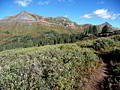
Silverton (9,318-ft.) is a wonderfully preserved mining town set in a high mountain valley surrounded by 13,000-ft. peaks. Primarily constructed between 1882 and 1910, the entire town is a national historic landmark and considered one of the most intact sites of its kind in the country.
Silverton is a little grittier and rougher around the edges then nearby Ouray. What the town lacks in polish it makes up for with location, surrounded by BLM land and three national forests featuring stunning alpine valleys, emerald green meadows and towering peaks. The Weminuche Wilderness, the State’s largest, is located southeast of town. The Continental Divide and the Colorado Trails traverse the high country to the south and east.
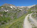
Getting to Silverton is its own adventure. The town lies sandwiched between high passes on Highway 550, aka the Million Dollar Highway, 23 miles south of Ouray and 50 miles north of Durango. Driving south from Ouray on 550, the narrow, winding highway ascends through fabulous scenery littered with mining ruins to cross Red Mountain Pass (11,018-ft.) before dropping to Silverton. The route north from Durango is just as spectacular, crossing Coal Bank (10,640-ft.) and Molas (10,970-ft.) Passes along the way.
Silverton Hiking Trails
Distance: 7.8 - 8.2 miles (Round Trip)
Difficulty: strenuous
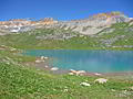
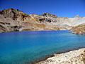
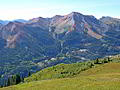
This wonderful hike visits two gorgeous lake basins, traverses wildflower-filled meadows and passes numerous waterfalls. Dramatic peaks punctuate the ridge forming the backdrop for upper Ice Lake, nestled in an alpine wonderland that invites exploration.
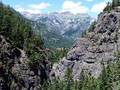
Bear Creek National Recreation Trail ![]()
Distance: 4.4 - 8.0 miles (Round Trip)
Difficulty: moderate-strenuous
A dramatic trail carved into a steep cliff face high above Bear Creek is just one of the highlights of this hike up a beautiful canyon to two scenic mine sites.
Distance: 6.0 - 7.7 miles (Round Trip)
Difficulty: moderate-strenuous
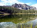
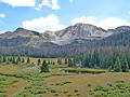
This trail ascends to gorgeous lakes set amid scenic alpine meadows with terrific views. An optional extension follows a segment of the Continental Divide, turning the hike into a loop with extended views of the surrounding peaks
Distance: 4.2 - 7.7 miles (Round Trip)
Difficulty: moderate-strenuous
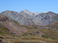
An old mining road leads to the heart of Spencer Basin, a beautiful, unspoiled and seldom visited valley surrounded by 13,000-ft. peaks. Here use trails and routes lead to two scenic passes.
Distance: 7.0 - 8.9 miles (Round Trip)
Difficulty: strenuous
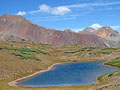
This little known hike climbs steeply through forest and beautiful alpine meadows to a stunning glacial lake set amid a backdrop of rugged 13,000-ft. peaks. Panoramic views from nearby Columbine Pass encompassing Bridal Veil Basin and the Sneffels Range.
Distance: 5.0 - 7.0 miles (Round Trip)
Difficulty: moderate
This scenic hike climbs to two pretty lakes in gorgeous Porphyry Basin. Along the way the trail travels through wildflower-filled meadows and passes waterfalls, interesting rock formations and mining ruins. The lovely alpine meadows of the upper basin offer several options for off-trail exploration.
Distance: 11.0 - 11.8 miles (Round Trip)
Difficulty: moderate
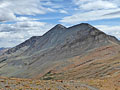
A scenic hike to a pretty lake nestled beneath North Twilight Peak (13,075). The hike can be extended by hiking to the saddle beyond the lake and/or scrambling to the top of North Twilight.
Distance: 5.1 - 6.3 miles (Round Trip)
Difficulty: moderate-strenuous
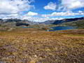
Alpine meadows, far-reaching views and solitude are the hallmarks of this scenic trail that ascends Minnie Gulch to the Continental Divide Trail (CDT) and then follows the CDT in either direction (or both) accompanied by amazing, panoramic views. The hike can easily be shorten or extended.
Distance: 5.2 - 7.0 miles (Round Trip)
Difficulty: moderate
This pretty trail travels along an old mining road through three wildflower-filled basins accompanied by grand views of the Red Mountains towering above the west side of the Million Dollar Highway. Ruins of the Barstow and Greyhound mines add interest to the walk.
Pass Creek and Engineer Mountain ![]()
Distance: 4.8 - 12.8 miles (Round Trip)
Difficulty: strenuous
This scenic hike, traveling through the high meadows to northwest of Coal Bank Pass, features terrific views of Engineer Mountain, Twin Sisters, the high peaks ringing the Cascade Valley and the summits rising to the south of Silverton.
Andrews Lake to Snowdon Peak Viewpoint ![]()
Distance: 2.2 miles (Round Trip)
Difficulty: moderate
This short hike ascends the slopes to the south of Andrews Lake, accompanied by fine views of the peaks to the north and west. The hike ends at a viewpoint with beautiful vistas of Snowdon Peak towering above a meadow clad bench with two small ponds.
Distance: 5.2 miles (Round Trip)
Difficulty: moderate-strenuous
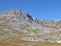
This nice half-day hike climbs on moderate to moderately-steep grades to a 12,450-ft. pass with panoramic views of the surrounding valleys and high peaks.
Colorado Trail: Little Molas Lake to Lime Creek ![]()
Distance: 7.4 - 10.1 miles (Round Trip)
Difficulty: moderate
A moderately easy hike along a segment of the Colorado Trail featuring panoramic views from the high meadows above the West Lime Creek valley.
View Hikes by Area:
Southwest ColoradoOurayTellurideSilvertonLake City
| Support our Site |
Around Town

During Silverton’s heyday in the 1880’s, millions of dollars in gold and silver extracted from nearby mines fueled construction of lavish hotels and ornate homes, occupied by the town’s law-abiding and respectable citizens, along with dance halls, brothels and saloons frequented by a rougher crowd. Because Silverton never experienced a major fire a good number of these buildings are still standing.
Today the town boasts of its dual personalities, the respectable half west of Greene Street (the town’s main drag) and the “red light district” east of Greene around notorious Blair Street, once home to over 40 saloons and brothels. Many of the restored structures on Greene, Blair and the adjacent side streets are now eclectic gift shops and restaurants catering to tourist.
Tourism is the mainstay of Silverton’s economy. During the summer and early fall the Durango and Silverton Narrow Gauge Railroad (D&SNG) makes the 45-mile run between Durango and Silverton several times a day, bringing an influx of tourists who spend a few hours sightseeing, shopping and eating before returning to Durango.
The town is also is a popular stop for sightseers driving the San Juan Skyway, a 233-mile loop with stunning scenery that crosses four high passes and connects Silverton to Ouray, Telluride, Cortez, and Durango (going clockwise around the loop).
By late afternoon most of the train tourists are gone and the town takes on a more relaxed and authentic atmosphere. The evenings are a good time to stroll the streets and appreciate the historic buildings. Take time to tour the backstreets west of Greene to see beautifully restored Victorian homes along with buildings undergoing restoration.
For a bird’s eye view of Silverton and the surrounding area take an evening stroll to the Christ of the Mine Shrine, a huge statue of Jesus in a stone alcove located 500 feet up the slope of Anvil Mountain north of Silverton. Reach the shrine by walking northwest on 10th Street to its end at Keystone Street where an obvious trail ascends the hillside to the statue.
Visit the tourist office for more information on other nearby short hikes. Good options include visiting the local Cemetery (2 miles), ascending to the Idaho Mine (3.1 miles) or walking along the Animas River south of town (1.6 miles)
The San Juan County Museum, located in the old San Juan County Jail at the northeast end of Green Street, is worth a visit and a good rainy day diversion. The museum features artifacts and displays explaining the history of the town, the area's mining legacy and the D&SNG railroad.
Nearby Attractions
When you need a break from hiking a visiting Animas Forks, a ghost town located 15 miles northeast of Silverton on County Road 2, is an interesting option. A surprising number of buildings and mining structure still stand at the site, inhabited from the 1870’s to the 1920’s. BLM plaques describe the structures and the history of the town. The dirt road leading to the site is accessible to passenger vehicles.
Another good diversion is the drive to Ouray along the 24-mile stretch of Highway 550 dubbed the Million Dollar Highway. The drive features incredible mountain scenery, deep canyons, sheer cliffs and numerous mining ruins. Ouray (7,746-ft.) is a pretty little Victorian town nestled beneath a dramatic granite amphitheater and surrounded by 12,000-ft. plus peaks. See the Ouray section of the guide for more information.
A tour of the Old Hundred Mine is a great option for a rainy day. To reach the mine travel 4 miles northeast from Silverton on County Road 2. Turn right onto Country Road 4A and follow the signs for 0.75 miles to the mine. The tour takes visitors 1,500-ft. into a gold mine for demonstrations of mining equipment and operations.
Self guided tours are available at the Mayflower Gold Mill, a National Historic Landmark located 2 miles northeast of Silverton on County Road 2. The tour explains the operation of the largely intact Mill that processed gold and silver for almost a half century.
Hikers with a 4WD vehicle or a mountain bike might want to investigate the old mining roads crisscrossing the backcountry around Silverton. Many lead to ghost towns, mining ruins and spectacular vistas. Be sure to check at the Silverton Visitor Center regarding road conditions and the skill level required to navigate the roads. Jeep rentals and 4WD tours of the backcountry are offered by various businesses in town.
The Alpine Loop, a National Backcountry Byway, is the area’s most popular backcountry adventure. From Silverton the 65-mile 4WD route starts at the ghost town at Animas Forks, climbs over Cinnamon Pass (12,620-ft.) and drops down to Lake City on Highway 149. From the south end of Lake City the return route follows the Henson Creek drainage to Engineer Pass (12,800-ft.) and then drops back down to Animas Forks. Along the way the route traverses beautiful mountain landscapes with panoramic vistas and passes historic ghost towns and mining sites.
Food, Lodging and Services
Greene Street (the town’s main drag), Blair Street and the adjacent side streets are lined with restaurants, cafes and quaint shops catering to tourist and outdoor enthusiast.
Accommodations range from B&B’s and small hotels, situated in historic buildings with period furnishings, to more modern motels. A variety of homes and apartments are available as vacation rentals. Four RV Parks are located in or near town while the surrounding national forests offer established campgrounds and dispersed camping opportunities.
The tourist information center (414 Greene Street) is on your right as you enter town at 414 Green Street. Silverton Grocery at 717 Greene Street stocks the basics needed to assemble a meal. Those looking for the wider selection should purchase groceries in Ridgway or Durango.
The Coffee Bear (1309 Greene Street) will satisfy your caffeine habit and has a good variety of baked goods, sandwiches and snacks. Outdoor World (1234 Greene Street) offers a nice selection of hiking and fishing gear along area maps and guidebooks.