Best Hikes in Glacier Natl Park, MT
Featured Hikes
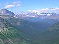
The Garden Wall / Highline Trail ![]()
Distance: 4.0 - 11.6 miles (Round Trip)
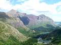
One of my favorite trails in the park, this moderately easy hike along the western flanks of the Continental Divide features panoramic views of the Livingston and Lewis Ranges along with excellent wildlife viewing opportunities.
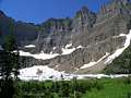
Distance: 5.0 - 9.6 miles (Round Trip)
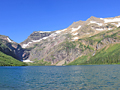
One of the most popular hikes in the Many Glacier area ascends a scenic valley to stunning Iceberg Lake, an aquamarine jewel cradled beneath a dramatic steep-walled cirque. Along the way enjoy fine views of the peaks surrounding the Swiftcurrent Valley, Ptarmigan Falls and the Ptarmigan Wall.
Distance: 7.6 - 18.4 miles (Round Trip)
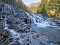
This spectacular hike climbs through gorgeous Glacier Basin, passes beautiful waterfalls and lovely alpine lakes before climbing to scenic Comeau Pass, with panoramic views of Glacier’s high peaks. A short walk beyond the pass leads to the ice expanse of Sperry Glacier.
Distance: 9.2 miles (Round Trip)
A scenic ascent of beautiful Preston Park and then a steep climb up pretty meadows and talus slopes leads to Siyeh Pass and the Baring/Boulder Divide, where stunning views unfold to the Sexton Glacier, Matahpi Peak, the Baring and Boulder Creek Valleys and beyond.
Distance: 8.5 - 13.0 miles (Round Trip)
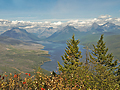
This terrific day hike leads to a high pass on the Continental Divide with breathtaking views of the Lewis Range and the Big Horn Basin. Along the way the trail enjoys stunning views of Two Medicine Lake, traverses scenic meadows and offers the chance to see wildlife.
Distance: 9.0 miles (Round Trip)
Splendid views of the peaks along the Continental Divide and rimming the Siyeh Creek Valley are the highlights of this scenic hike to Piegan Pass (7,570-ft.).
Distance: 19.4 miles (One Way)
Memorable backpack over Gunsight and Lincoln Passes travels by gorgeous Gunsight Lake and Lake Ellen Wilson set amid towering peaks adorn with glaciers and waterfalls. Wildflowers and wildlife add to the hike’s delights.
Distance: 10.1 miles (One Way)
Stunning views of Preston Park, the Baring-Boulder Divide and the Baring Creek Valley are the highlights of this great hike circumnavigating the Going-to-the-Sun Mountain and Matahpi Peak massif. The hike uses the Glacier shuttle bus to complete the loop.
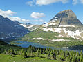
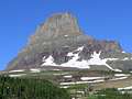
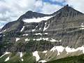
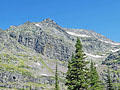
Hidden Lake Overlook and Hidden Lake ![]()
Distance: 2.6 - 5.2 miles (Round Trip)
Nonstop, panoramic views of the high peaks and alpine meadows around Logan Pass and a stunning overlook above Hidden Lake Basin make this one of the most popular outings in Glacier National Park. Extend the hike by visiting beautiful Hidden Lake.
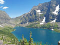
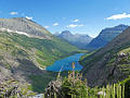
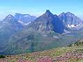
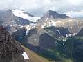
Gunsight Pass from Sperry Chalet ![]()
Distance: 8.5 - 10.2 miles (Round Trip)
Cross two passes and travel above the shores of Lake Ellen Wilson on this superb hike with unsurpassed views of Mount Jackson, Gunsight Mountain, Lake Ellen Wilson and Gunsight Lake. Waterfalls, wildlife sighting and wildflowers add to the trail’s appeal.
Distance: 15.2 - 17.4 miles (Round Trip)
This long, strenuous hike, best done as a backpack, travels through some of the best scenery in the southern half of Glacier National Park.
Distance: 7.2 - 10.4 miles (Round Trip)
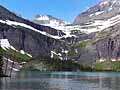
This popular hike, with fabulous views of the Cataract and Grinnell valleys, climbs through pretty meadows and along rock ledges to Upper Grinnell Lake and Grinnell Glacier, cradled in a dramatic cirque along the Continental Divide.
Distance: 8.0 - 13.6 miles (Round Trip)
This beautiful hike up the Swiftcurrent Valley passes a chain of lovely lakes with terrific views of the surrounding peaks and then climbs a steep trail up to a pass on the Continental Divide. The trail to the divide features panoramic views of Swiftcurrent Glacier and the valley
Distance: 11.8 miles (Round Trip)
A lovely drive up Glacier’s North Fork Valley leads to Bowman Lake. Here the Numa Ridge trail climbs its namesake ridge to a working fire tower with fine views of the peaks rising along the southeast side of the lake and west across the North Fork Valley.
Distance: 7.0 miles (Loop)
Combine the north and south shore trails around Lake Josephine to create an easy, scenic day hike to exquisite Grinnell Lake, set amid a spectacular cirque. Glaciers along the flanks of the cirque feed photogenic waterfalls that tumble down steep cliffs to the lake’s western shore.
Distance: 12.2 miles (Round Trip)
A hike through forest with limited views leads to stunning vistas of Mount Jackson Gunsight Mountain and Fusillade Mountain towers above gorgeous Gunsight Lake as well as views of Citadel Mountain, Mount Logan and the Blackfoot and Jackson Glaciers.
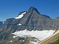
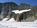
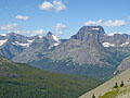
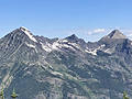
Sperry Chalet via the Gunsight Pass Trail ![]()
Distance: 12.4 miles (Round Trip)
A sustained ascent through trees for 4.0 miles and then more open terrain leads to the foot of stunning Glacier Basin, the Sperry Chalet and Sperry Campground. The area is a great basecamp for visiting the Sperry Glacier, Lincoln Pass and Gunsight Pass.
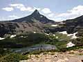
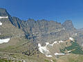
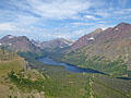
Cobalt Lake and Two Medicine Pass ![]()
Distance: 9.0 - 15.4 miles (Round Trip)
This hike travels up a long, pretty valley to Cobalt Lake and then climbs to a scenic pass on the Continental Divide with panoramic views of the peaks surrounding the Park Creek Valley to the west along with Sinopah Mountain, Mt. Rockwell and Painted Teepee Peak.
Distance: 10.2 miles (Round Trip)
Lovely, lightly trafficked trail ascends to a high pass in the southern section of Glacier National Park with fine views of the peaks rising above the Railroad Creek and Ole Creek Valleys. In season the meadows along the trail are awash in wildflowers.
Distance: 13.0 miles (Round Trip)
Long beautiful hike up the Cataract Creek Valley to Piegan Pass features stunning views of the high peaks and rugged ridge defining the Garden Wall. From the pass view stretch southeast to Mt. Siyeh, Matahpi Peak and Going to the Sun Mountain.
Distance: 11.0 miles (Round Trip)
This moderately strenuous hike ascends to a tunnel piercing the Ptarmigan Valley’s knife-edge headwall with stunning views of the peaks soaring above Many Glacier area to the south and the Belly River Valley to the north.
Distance: 10.2 miles (Round Trip)
Breathtaking views of the high peaks of the Lewis Range to the north, the summits of the Great Bear Wilderness to the south and the Lake McDonald area reward hikers completing this strenuous climb to a fire tower on Mt. Brown’s southwest ridge.
Distance: 6.2 - 7.7 miles (Round Trip)
Panoramic, bird’s-eye-views of the high peaks rimming the Two Medicine Valley and beyond is the reward for hikers making the sustained, moderately-steep climb to a ridge high above the southeast end of Two Medicine Lake.
Distance: 6.0 miles (Round Trip)
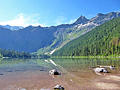
This popular hike, traveling through a forest of red cedars, larches and western hemlocks, leads to photogenic Avalanche Lake. The first section of the hike enjoys fine views of Avalanche Creek. For more great views of Avalanche Creek, return via the Trail of the Cedars.
Distance: 3.2 - 3.8 miles (Round Trip)
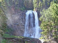
If you like waterfalls you’ll love the hike to beautiful St. Mary and Virginia Falls. The short, popular hike features mountain views and an ascent up the lovely Virginia Creek Valley, passing multiple smaller cascades before reaching impressive Virginia Falls.
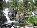
Twin Falls and Upper Two Medicine Lake ![]()
Distance: 2.2 - 9.8 miles (Round Trip)
This easily hike features stunning views of the peaks surrounding the Two Medicine Valley, visits a beautiful pair of cascading waterfalls and a end at a scenic lake ringed by rugged peaks.
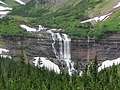
Distance: 6.4 - 9.2 miles (Loop)
This pleasant hike visits two pretty waterfalls, Feather Plume Falls and Morning Eagle Falls, in the lovely Cataract Creek Valley. Beyond the falls the trail climbs steeply to Piegan Pass.
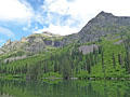
Distance: 8.5 miles (Round Trip)
This pleasant jaunt leads to pretty Snyder Lake set amid a rugged cirque. The trail is a nice early season option and offers a good workout. Areas burnt by the 2017 fire are recovering and now feature good views of the surrounding peaks.
Distance: 5.3 miles (One Way)
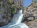
This great little hike visit three scenic waterfalls and travels through a section of the 2015 Reynolds Creek Fire where burnt timber has opened new views. The point-to-point hike makes use of the Park’s excellent Shuttle Bus system.
Distance: 1.9 miles (Loop)
This nice hike near the head of Lake McDonald passes peaceful John’s Lake and then wanders by Sacred Dancing Cascade and McDonald Falls along McDonald Creek. Great hike for families or anyone looking for an easy stroll near the Lake McDonald Lodge.
Distance: 7.2 miles (Round Trip)
This nice hike ascends to an old fire lookout atop a shoulder of Apgar Mountain with partially obstructed birds-eye-views of the Lake McDonald area.
View Hikes by Area:
Many GlacierSt MaryTwo MedicineLake McDonald
The Region, the Hikes & the Base Camps
Glacier National Park is a hikers paradise boasts over 700 miles of trails ranging from short nature walks to extended backpacks traveling through some of the most spectacular and wild country in the Rockies.
Base Camp Information: Many Glacier / St Mary / Two Medicine / Lake McDonald