Details: Kearsarge Pass 
Distance: 9.6 miles (round trip)
John Muir Wilderness Area, Inyo National Forest, near Lone Pine in California's Southeastern Sierra
By: Diane Greer
Hike Facts
- Distance: 9.6 miles (round trip)
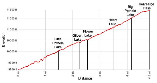
- Elevation: 9,200-ft. - 11,823-ft.
- Elevation Gain: 2,623-ft.
- Difficulty: strenuous
- Trail Highlights: See Trail Intro
- Basecamp(s): Lone Pine / Bishop
- Region: California's Southeastern Sierra
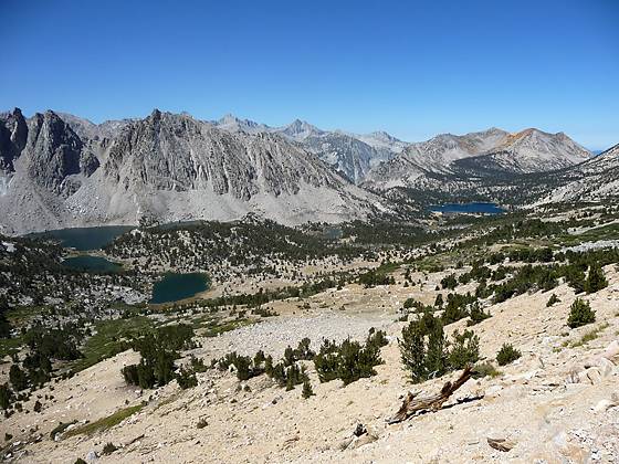
The scenic hike to Kearsarge Pass (11,823-ft.) travels by five shimmering lakes and features great views of the rugged crags and peaks along the east side of the Sierra Crest. From the pass breathtaking views encompass the Kearsarge Lakes, the Kearsarge Pinnacles and the Kings-Kern Divide.
Trailhead to Kearsarge Pass
The trail to Kearsarge Pass, which starts at the west end of the trailhead parking area, wastes no time gaining elevation. From the trailhead bulletin board the trail begins climbing switchbacks on moderate grades through dry slopes clad in sagebrush and manzanita. Along the way pass a spur trail connecting with the Golden Trout Lakes trail at 0.3 miles and the boundary of the John Muir Wilderness at 0.8 miles. As you climb enjoy ever improving views of Onion Valley and the Inyo Mountains rising above the Owens Valley to the east.
Beyond the wilderness boundary the trail curves to the northwest, following an ascending traverse along the hillside to the north of Independence Creek and then climbs switchbacks to the basin holding Little Pothole Lake, 1.5 miles from the trailhead. Waterfalls spill down the rugged slopes to the south and west of this pretty little crescent shaped pond.
The trail now switchbacks up the rocky slope to the north of the Little Pothole Lake. At the top of the switchbacks the trail traverses a boulder field and arrives at Gilbert Lake (10,417-ft.), 2.25 miles from the trailhead. This scenic little lake enjoys fine views of University Peak (13,589-ft.) and the rugged ridge to the south. The rocky hillsides around the lake shore, lined with willows and pines, harbors highly used campsites.
The grade temporarily abates as the trail contours around Gilbert’s north shore. Once you are past the lake the climb resumes. At 2.5 miles the trail arrives at the east end of lovely Flower Lake (10,531-ft.) where a use trail crosses Independence Creek and heads south toward Matlock and Bench Lakes. University Peaks towers above the rock hillside to the south of the lake. Good campsites are located to the north and east of the lake.
At Flower Lake the trail curves to the north, ascending on moderate grades through scattered pines before turning northwest again and climbing along the base of the steep talus clad slopes to the north of the trail. At 3.2 miles the trail briefly veers to the southwest, arriving at a great overlook high above Heart Lake, 3.5 miles from the trailhead. Take a break from the stiff climb to enjoy the great views of the lake and jagged peaks and pinnacles rising to the south.
After taking in the view, follow the trail as it climbs a series of switchbacks up a headwall to the basin below Kearsarge Pass and then ascends on long switchbacks across stark, talus covered slopes along the north side of the basin. The climb offers splendid birdseye views of Big Pot Hole Lake (4.2 miles) and the rugged peaks and ridges, anchored by University Peak, to the south.
One long final switchback propels you to the top of Kearsarge Pass (11,823-ft.), 4.8 miles from the trailhead, where signs mark the border of Kings Canyon National Park. From the pass enjoy stunning views of the Kearsarge Pinnacles, Kearsage Lakes and Bull Frog Lake to the west. In the distance are the summits of the Kings-Kern Divide. Big Pothole Lake sits in a deep bowl below the trail to the east, framed by University Peak and the jagged ridge running south along the Sierra Crest. In the distance to the east are the Inyo Mountains.
The trail continues beyond the pass, descending to the west into the scenic backcountry of King Canyon National Park and connecting with the John Muir Trail (JMT). Popular backpacking destinations to the west of the pass include the Kearsarge Lake and the Rae Lakes. Quite a few backpackers use Kearsarge Pass as an entry or exit leg on long backpacking trips along the JMT heading south to Cottonwood Pass/New Army Pass or north to Bishop Pass and Piute Pass.
Elevation Profile
Driving Directions
From Lone Pine: Head north on US Highway 395 N for 15.6 miles to Independence and turn left (west) on the Market Street, signed for the Onion Valley. Market Street turns into the Onion Valley Road in 0.2 miles. Follow the Onion Valley Road for 12.8 miles to the trailhead parking area. The trial head is located at the west end of the smaller parking area.
From Bishop: Head south on US Highway 395 S for 41.5 miles to Independence and turn right (west) on the Market Street, signed for the Onion Valley. Market Street turns into the Onion Valley Road in 0.2 miles. Follow the Onion Valley Road for 12.8 miles to the trailhead parking area. The trial head is located at the west end of the smaller parking area.
Trail Resources
Trail Intro / Trail Photo Gallery / Trail Map
Basecamp(s) Information:
Lone Pine / Bishop
Region Information:
California's Southeastern Sierra
Other Hiking Regions in:
California