Details: Bear Lake 
Distance: 11.0 miles (round trip)
Collegiate Peaks Wilderness, San Isabel National Forest, near Buena Vista in Central Colorado
By: Diane Greer
Hike Facts
- Distance: 11.0 miles (round trip)
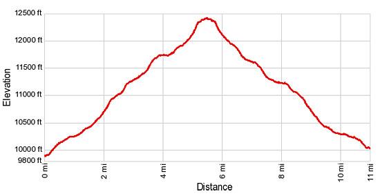
- Elevation: 9,890-ft. - 12,410-ft.
- Elevation Gain: 2,520-ft.
- Difficulty: moderate-strenuous
- Trail Highlights: See Trail Intro
- Basecamp(s): Buena Vista
- Region: Central Colorado
Great views of three Colorado 14ers; Mt. Harvard, Mt. Columbia and Mt. Yale, are the rewards of this hike up the scenic Horn Fork basin to Bear Lake, an alpine jewel nestled in a rugged bowl beneath the Continental Divide in the Collegiate Peaks Wilderness.
To Bear Lake
The Horn Fork Trail to Bear Lake and Mt. Harvard starts at the southwest side of the North Cottonwood Creek trailhead. (See driving directions.) Follow the trail as it heads west through trees for 0.15 miles and then crosses a good wood bridge to the south side of North Cottonwood Creek. Beyond the bridge the trail ascends on moderate grades through a spruce-fir forest, passing the boundary of the Collegiate Peaks Wilderness at 0.6 miles.
Just past the wilderness border the grade abates and the trail now ascends on easy grades beside the creek. Cross back to the north side of the creek on a wood bridge at 1.6 miles and a short distance beyond reach a trail junction. The trail branching to the left (west) leads to Kroenke Lake and Brown’s Pass. We bear right on the Horn Fork Trail toward Horn Fork Basin and Bear Lake.
The trail now heads northwest, climbing the hillside along the north side of the valley on moderately-steep grades. Intermittent openings in the trees offer nice views of Mt Yale to the southwest. The grade eases at 2.25 miles as the trail curves into the Horn Fork valley. A quarter mile beyond logs and rocks facilitate the crossing of a creek draining the south ridge of Mt. Columbia.
Past the crossing follow the trail as it climbs on moderate to easy grades along the east side of the Horn Fork Valley. At 3.0 miles the path skirts the east edge of a small meadow. Here views open to the ridge rimming the western side of the valley. A short distance beyond a second meadow offers views of Mt. Columbia towering above the east side of the valley.
Soon the trail reenters the trees, ascending the valley on moderate grades. At 3.9 miles the trees give way to a large park revealing Mt. Harvard, the high point of the stunning cirque at the head of the valley. The trail now curves to the east to avoid the willow-choke valley floor.
Soon the trail curves back to the north and continues its moderate ascent up the valley beneath Mt. Columbia’s west face and the rugged ridge lining the west side of the valley. Along the way enjoy ever improving views of Mt. Harvard and the unnamed jagged peaks ringing the head of the valley. Turn around for great views of Mt. Yale rising to the south.
Cross to the west side of Horn Fork Creek at 4.3 miles and then ascend a small rise with scatter Krummholz firs. Soon we pass the last of the stunted firs. The trail now travels up valley through alpine meadows scattered with clusters of low willows. As you gain elevation, Mt. Princeton is now visible in the distance to the south.
At 5.2 miles the trail curves to the left (west) as it crests the top of a bench and reaches the unmarked junction with the trail to Mt. Harvard branching to the right (north). We continue heading west toward Bear Lake, crossing the nascent Horn Fork. Look right (north) to see hikers climbing a rocky trail to a saddle on the way to Mt. Harvard. Ahead jagged unnamed peaks tower above the west side of the valley.
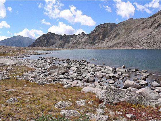
A short climbs leads to Bear Lake (12,374-ft.) at 5.5 miles. This starkly beautiful jewel lies nestled on a rocky shelf beneath the Continental Divide, which runs along the valley’s rugged west ridge. From the lake enjoy great views of Mt. Harvard, Mt. Columbia, Mt. Yale and in the distance Mt. Princeton, along with the unnamed peaks and ridges surround the head of the valley. Fishermen may want to try their luck catching the lake’s cutthroat trout.
Parties wishing to overnight will find exposed and windy campsites around the lake. The best campsites are located in the trees a mile and a half below the lake. These sites are often crowded with hikers who spend the night in the Horn Fork basin and then summit Mt Harvard on the second day.
When you are done enjoying Bear Lake, retrace your steps to the trailhead for an 11.0 mile round trip hike.
Elevation Profile
Buy the BookThis opinionated guide includes all the hikes in the Aspen, Buena Vista, Crested Butte, Marble and Leadville sections of the website plus info on local services and nearby attractions. | |
Driving Directions
Driving Directions from Buena Vista: From the traffic light at the intersection of U.S.24 and Country Road 306 in downtown Buena Vista, drive north on U.S. 24 W for three blocks (0.7 miles) and turn left on Crossman Avenue (CR 350). The turn is just beyond the Super 8 in Buena Vista.
Follow CR 350 for 1.8 miles to a “T” intersection and turn right on CR 361. Drive on CR 361 for 0.9 miles to a 2nd “T” intersection and turn left on CR 365. Follow CR 365 for 5.1 miles to the North Cottonwood Creek trailhead at the end of the road. The road gets noticeable rougher after the first 2.0 miles. Beyond this point normal passenger cars can make it to the trailhead if driven carefully. High clearance is better.
This is a very popular trailhead providing access to Mt. Harvard. As such it fills early in the morning during the summer. Additional parking is available along the road leading to the parking lot. Be sure to pick a spot that is well off the road.
Trail Resources
Trail Intro / Trail Photo Gallery / Trail Map
Basecamp(s) Information:
Buena Vista
Region Information:
Central Colorado
Other Hiking Regions in:
Colorado