Details: Browns Lake 
Distance: 5.8 - 12.0 miles (round trip)
San Isabel National Forest, near Buena Vista in Central Colorado
Hike Facts
- Distance: 5.8 - 12.0 miles (round trip)
- Elevation: 8,920-ft. - 11,320-ft.
- Elevation Gain: 950-ft. - 2,400-ft.
- Difficulty: moderate-strenuous
- Trail Highlights: See Trail Intro
- Basecamp(s): Buena Vista
- Region: Central Colorado
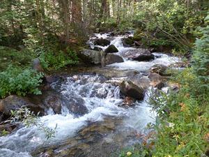
Pretty streams, an amazing waterfall and a lovely lake set amid a beautiful basin are some of the scenic rewards of the hike to Brown’s Lake in the San Isabel National Forest.
Trailhead to Browns Falls
Distance from Trailhead: 5.8 miles (round trip)
Ending/Highest Elevation: 9,870-ft.
Elevation Gain: 950-ft.
The trail to Brown’s Lake begins at the northwest end of the Brown’s Creek trailhead parking area. (See driving directions.) Follow the trail as it ascends west through ponderosa pine for a quarter mile and then briefly turns north, climbing moderately-steep switchbacks up an old moraine to the north of Little Brown’s Creek. As the trail crests the moraine it turns left (west) and resumes its moderate ascent through trees along the top of the moraine. Views open to Mount White (13,667-ft.) and the north face of Jones Peak (13,604-ft.) to the west/southwest.
After 0.9 miles the grade eases and soon the trail curves to the southwest, reaching the signed junction with the Colorado Trail at 1.4 miles. Turn left (southwest) on the Colorado Trail in the direction of Browns Creek Falls (1.5 miles) and Brown Lake (4.5) miles. The trail to the right leads to the Little Browns Creek trail in 0.3 miles.
Cross Little Browns Creek on a wood bridge at 1.6 miles. Just beyond the creek reach a “Y” intersection. Bear right on the trail bound for Browns Creek Falls (1.3 miles) and Brown Lake (4.3) miles. The Colorado Trail continues south on the trail branching to the left.
At 1.7 miles the trail crosses a tributary stream on logs and then heads south on easy grades along a good trail. Soon the trail curves to the southwest and heads up the north side of the Browns Creek drainage.
At 2.4 miles the trail travels through a large meadow with nice views of the north face of Jones Peak. Beyond the park the path plunges back into the trees and reaches Browns Creek at a wide ford. Hikers should backtrack a short distance to find a trail branching northwest. This trail leads to log bridge facilitating the crossing to the south side of the creek at 2.6 miles. Cross back to the north side of the creek on a second log bridge at 2.7 miles.
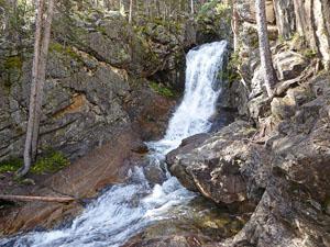
A small wood sign on a pile of rocks at 2.8 miles points left (south) to Browns Creek Falls. I highly recommend taking the short detour that climbs about 50-ft. up a hillside to the falls at 2.9 miles. This stunning cascade gushes over a long drop and then a shorter drop into a pretty pool. Rock ledges around the pool beacon hikers to take a break and enjoy the spectacle.
The falls is a popular destination for families and parties looking for a nice half day hike. Total hiking distance to the falls and back is 5.8 miles with an elevation gain of 950-ft.
Browns Falls to Browns Lake
Distance from Trailhead: 12.0 miles (round trip)
Ending/Highest Elevation: 11,320-ft.
Elevation Gain: 2,400-ft.
To hike to Browns Lake return to the main trail and follow the rocky path as it climbs up a hillside on moderately-steep grades. Soon the trail curves around a minor ridge extending from the north side of the valley. At 3.6 miles the path resumes its westerly course, ascending above the north side of Brown’s Creek, which tumbles down a rocky gully below the trail.
The grade briefly eases at 4.0 miles as the trail travels alongside the creek. Soon a short, steep climb leads to the next level of the valley. Here the trail ascends on easy to moderate grades through a large blowdown, an area along the valley floor where high winds have uprooted, toppled and snapped trees like matchsticks. One can only image the force of the wind required to cause this level of destruction.
For the next 0.8 miles you will travel through areas affected by the windstorm. It is obvious that an enormous effort was required to clear downed trees from the trail.
On the bright side, openings caused by the toppled trees offer fine views of the craggy north face of the Jones Peak massif to the south and Mount White to the north. Young aspen and conifers are now repopulating the area. During the height of the season, a profusion of wildflowers grow amid the downed trees.
Pass an interesting teepee-shaped rock formation along the lower slopes of Mt. White at 5.2 miles. Beyond the formation we soon leave the last of the down trees behind and now ascend through healthy forest on moderate grades.
At 5.9 miles the trees give way to meadows and views open to a waterfall along Browns Creek to the south. The rugged slopes of Jones Peak massif tower overhead.
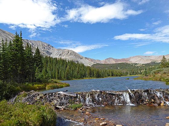
Follow the trail as it climbs steeply through rocky meadows scattered with trees and low willows to lovely Browns Lake (11,286-ft) at 6.0 miles. At the east end of the lake water spills over a beaver dam into Browns Creek. The long narrow lake stretches along the valley floor between the west ridge of Jones Peak to the south and White Mountain to the north. Carbondale Mountain (13,663-ft.), Cyclone Mountain (13,596-ft.) and Cronin Peak (13,870-ft.), along with a few unnamed peaks, ring the head of the valley. Tabeguache Peak (14,155-ft.) rises to the southwest. During the height of the summer the lake basin’s meadows are filled with wildflowers.
The foot of the lake is the turnaround point for day hikers. Backpackers will find nice campsites to the west of the lake. Fishermen report good luck catching cutthroats along the lake's south shore.
The trail continues heading west along the north side of the lake and its inlet stream for half a mile to a jeep road. The jeep road, which starts in the Chalk Creek valley, heads up the Baldwin Valley, climbs the west facing slopes of Mt. Antero and then descend to Browns Creek. Along the way the road links up with the trail climbing Mt Antero (14,269-ft.).
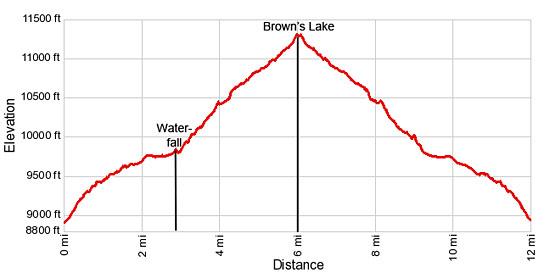
Elevation Profile
Buy the BookThis opinionated guide includes all the hikes in the Aspen, Buena Vista, Crested Butte, Marble and Leadville sections of the website plus info on local services and nearby attractions. | |
Driving Directions
Driving Directions from Buena Vista: From the traffic light at the intersection of U.S.24 and Country Road (CR) 306 in downtown Buena Vista, drive south on US 24 E for 2.4 miles to an intersection. Here US 24 turn east. We continue straight ahead on U.S. 285 S for 8.8 miles and turn right (west) on County Road (CR) 270 W.
Follow CR 270 for 1.5 miles to the 4-way intersection. CR 270 turns right. We continue heading west (straight ahead) on Forest Road (FR) 272 for 2.0 miles to an intersection. Turn left (south) to stay on FR 272.
Follow FR 272 for 1.6 miles to the Brown’s Creek trailhead on the right (west) side of the road. Additional parking is found on the east side of the road. The trail starts at the northwest end of the parking area.
Trail Resources
Trail Intro / Trail Photo Gallery / Trail Map
Basecamp(s) Information:
Buena Vista
Region Information:
Central Colorado
Other Hiking Regions in:
Colorado