Details: Bear Creek National Recreation Trail 
Distance: 4.4 - 8.0 miles (round trip)
Uncompahgre National Forest, near Ouray in Southwest Colorado
By: Diane Greer
Hike Facts
- Distance: 4.4 - 8.0 miles (round trip)
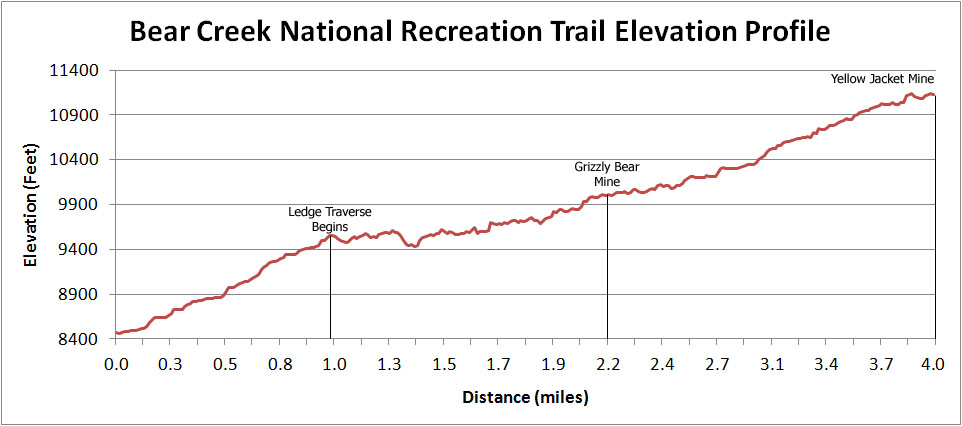
- Elevation: 8,470-ft. - 11,130-ft.
- Elevation Gain: 1,560-ft. - 2,660-ft.
- Difficulty: moderate-strenuous
- Trail Highlights: See Trail Intro
- Basecamp(s): Ouray / Silverton
- Region: Southwest Colorado
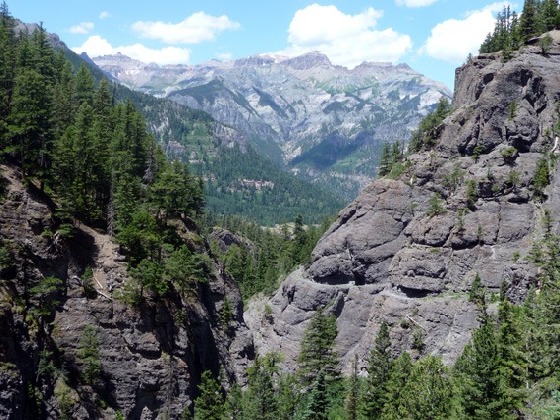
A dramatic trail carved into a steep cliff face high above Bear Creek is just one of the highlights of this hike up a beautiful canyon to two scenic mine sites.
Trailhead to the Grizzly Bear Mine
Distance from Trailhead: 4.4 miles (round trip)
Ending/Highest Elevation: 10,030-ft.
Elevation Gain: 1,560-ft.
The Bear Creek National Recreation Trail starts on the west side of Highway 550, 2.5 miles south of Ouray. (See driving directions.) From the parking area on the east side of the road, carefully cross to the west side of the road and then follow the trail as it climbs over a road tunnel to the north of the parking lot. In a short distance reach the trailhead registry and the beginning of a series of long, moderately steep switchback ascending the east side of the Uncompahgre Gorge, a deep mountain canyon formed by the Uncompahgre River.
The lower sections of the switchbacks climb through a mixed conifer forest, passing some impressive old white firs. As the trail gains elevation the trees give way to open slopes. Here the trail ascends through rock slides composed of slate and quartzite. Terrific views open to the Mt. Sneffels range across the valley to the west and the town of Ouray to the north.
Reach the top of the switchbacks in slightly under a mile having gained 1,000-ft. The grade now moderates as the trail enters the Bear Creek drainage, heading east across a talus slope high above Bear Creek. Views to the south extend to Red Mountain pass. A section of the San Juan Skyway (Million Dollar Highway) is visible in the distance.
Soon the trail levels off following the contours of the canyon's steep walls on a narrow ledge carved into the talus cliff. Footing is generally good except for a few short eroded sections.
One can only image the effort required to build and maintain this route. As you hike along the ledge note how sections of the trail are supported by logs and rubble fill. Across the canyon look for mines dug in the steep canyon walls. The walk along the ledge (0.8 miles) ends where it crosses a rocky drainage.
The trail now ascends moderately on dry slopes with intermittent pockets of trees. About 0.2 miles before the Grizzly Bear Mine the trail enters a nice stand of aspens. Keep an eye out for a metal sided shed on your left. Shortly thereafter mining equipment and a collapsed wood building with a corrugated aluminum roof lie scattered along the side of the trail. This is the Grizzly Bear mine (10,020-ft.), located 2.2 miles and 1,560-ft. up from the trailhead.
The mine is a nice destination and a good turn around point for hikers with limited time (and energy). Otherwise, after exploring the area continue the hike to the Yellow Jacket mine, located 1.8 miles ahead.
Grizzly Bear Mine to the Yellow Jacket Mine
Distance from Trailhead: 8.0 miles (round trip)
Ending/Highest Elevation: 11,130-ft.
Elevation Gain: 2,660-ft.
The trail to the Yellow Jacket mine ascends on a moderate grades above the left (north) side of Bear Creek through intermittent forests of mix conifers and aspens. At 2.7 miles (10,200-ft.) rock-hop across a tributary of Bear Creek. Look for a post marking the continuation of the trail on the other side. Shortly after crossing the stream the path traverses a pretty, wildflower-filled meadow with views of peaks to the north and east.
The trail now continues its moderate to moderately-steep ascent, aided by occasional switchbacks, through meadows and trees. Reach the Yellow Jacket mine (11,130) at 4.0 miles having gained over 2,660-ft. The site, flanked by steep grassy meadows and talus slopes, is littered with mine debris and includes the ruins of a photogenic wood building. To the west distant views of the Mt. Sneffels range fill the skyline.
Slightly beyond the mine site a signposts points the way to the Horsethief trail, which ultimately leads to the Bridge of Heaven and Engineer Pass. Both destinations are too far for a day hike.
To complete your hike, return the way you came.
Elevation Profile
| Buy the BookThis opinionated guide includes all the hikes in the Ouray, Telluride, Silverton and Lake City sections of the website plus info on local services and nearby attractions. |

Driving Directions
Driving directions from Ouray: Take Highway 550 (aka the Million Dollar Highway) 2.5 miles south of Ouray. The trailhead parking lot is on the east side (left) of the road immediately after the road passed through a small tunnel. The trailhead is on west side (right) of the road.
Trail Resources
Trail Intro / Trail Photo Gallery / Trail Map
Basecamp(s) Information:
Ouray / Silverton
Region Information:
Southwest Colorado
Other Hiking Regions in:
Colorado