Details: Grinnell Lake 
Distance: 7.0 miles (loop)
Glacier National Park, near Many Glacier in Glacier Natl Park, MT
Hike Facts
- Distance: 7.0 miles (loop)
- Elevation: 4,820-ft. - 5,050-ft.
- Elevation Gain: 230-ft.
- Difficulty: easy
- Trail Highlights: See Trail Intro
- Basecamp(s): Many Glacier / St Mary
- Region: Glacier Natl Park, MT
Combine the north and south shore trails around Lake Josephine to create an easy, scenic day hike to exquisite Grinnell Lake, set amid a spectacular cirque. Glaciers along the flanks of the cirque feed photogenic waterfalls that tumble down steep cliffs to the lake’s western shore.
Grinnell Lake Loop
Note: Hikers can ride the tour boat leaving from the Many Glacier Hotel to shorten the hike to Grinnell Lake. The round trip boat tour will reduce the hiking distance to 2.4 miles (round trip). Taking the boat one way and walking the North Shore Lake Josephine trail the other direction will shorten the hiking distance to 5.8 miles.
The two stage boat trip starts from the west side (lake side) of the Many Glacier Hotel and cross Swiftcurrent Lake. At the end of the lake tour participants disembark and walk 400 yards to the foot of Josephine Lake where a second boat waits to take the tour to the head of Josephine Lake. At the head of Josephine Lake trails connect to the trail leading to Grinnell Lake.
This description assumes hikers do not take the boat.
The trailhead to Grinnell Lake and Grinnell Glacier is located at the southwest end of the Many Glacier Picnic parking area (see driving directions below). Follow the trail as it head south through forest and small meadows, crossing a bridge over Wilbur Creek at 0.25 miles. The bridge offers nice views Mt. Wilbur and Iceberg Peak to the northwest.
Reach the western shore of Swiftcurrent Lake at 0.4 miles. From the shore views extend south/southeast across the lake to Allen Mountain (9,376-ft.) mountain and a few unnamed peaks. The trail now travels through trees along the western shore.
Reach atrail junction at the head of Swiftcurrent Lake at 0.7 miles. Turn right (southwest) on the North Shore Josephine Lake trail in the direction of Grinnell Lake and Grinnell Glacier. Straight ahead is the trail looping Swiftcurrent Lake.
The paved, forested trail crosses an ancient glacial moraine to a second trail junction in 0.2 miles. The junction is near the boat dock at the food of Lake Josephine. Bear right (west) at the junction to continue along the North Shore trail. The trail to the left heads to the dock.
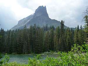
Beyond the junction the North Shore trail reverts to a dirt path, traversing the lake’s northwestern shore on easy grades beneath the rugged slopes of Grinnell Point (7,600-ft.). Avalanches plowing down the slopes of Grinnell Point have clear most of the trees from the hillsides along the lakeshore, allowing for unobstructed views of the peaks surrounding the valley. Allen Mountain (9,376-ft.) towers above the lake to the south while Mt. Gould (9,553-ft.) and the Garden Wall along the Continental Divide dominate the view at the head of the valley.
At 1.6 miles the trail to Grinnell Glacier branches off to the right. Continue straight ahead on the North Shore Trail toward Grinnell Lake. Reach a junction with a spur trail connecting to the Grinnell Glacier trail at 2.0 miles. The spur, used by hikers taking the boat to the head of Lake Josephine, climbs a few steep switchbacks to the main trail to the glacier. Our trail curves to the left (south) around the head of Lake Josephine, along the way traveling through willow groves and crossing a bridge Cataract Creek.
Arrive at the junction with the trail to Grinnell Lake at 2.2 miles. Turn right (southwest) on the trail to the lake. The trail bearing left is the South Shore Lake Josephine Lake trail leading to the Oastler Shelter and the boat dock at the head of Josephine Lake and ultimately back to the Many Glacier Picnic area trailhead. This is the return route for the loop trip to Grinnell Lake.
The Grinnell Lake trail travels on easy grades through pleasant forest. Two-tenths of a mile from the junction the path briefly traverses alongside Cataract Creek. Boardwalks, at 2.8 miles, span a swampy section of the trail.
Cross Cataract Creek on a swing bridge at 3.1 miles. Only one hiker at a time is allowed on the bridge. Walk with one foot in front of the other to minimize the movement of the bridge and hold onto the hand cables. (Note: On the east side of the swing bridge a short spur trail on the left climbs switchbacks to Hidden Falls where Cataract Creek rushes down a deep, narrow gorge. This is a worthwhile side trip for hikers with the time and energy.)
Just before reaching the lake the trail crosses more boardwalks spanning a marshy area. This section of the trail offers fine views of Angel Wing (7,430-ft.) rising to the west. Just before the end of the boardwalks reach a junction with the trail to Piegan Pass and Feather Plume falls, heading left (south). Continue straight ahead to the lake.
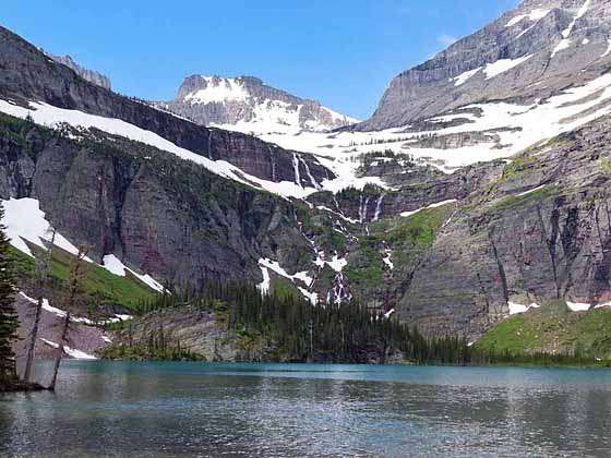
Grinnell Lake (5,040-ft.), 3.4 miles from the trailhead, lies in a dramatic cirque beneath the towering walls of Mt. Gould, the Garden Wall and Mt. Grinnell (8,851-ft.). Melt water from the Salamander and Grinnell Glaciers spill down a beautiful waterfall and into the western end of Grinnell Lake.
The lake, the glacier and the mountain are named after George Bird Grinnell, who first visited the area in 1885 while he was the editor of Field and Stream, a popular outdoor magazine. Over the ensuing years he explored the area and advocated for the establishment of Glacier National Park.
After enjoying the scenic lake, retrace your steps to the trail junction at the head of Lake Josephine at 4.6 miles (1.2 miles from the lake). Here you have a choice of returning the way you came via the North Shore Trail, taking the shuttle boat back to the Many Glacier Hotel or walking back along the South Shore Josephine Lake trail.
If time and energy permit the walk along the South Shore is quite pleasant. From the junction at the south end of Lake Josephine continue essential straight on the trail along the lake’s southeast shore. In a short distance pass the spur trail, heading left, toward the Oastler Shelter and the boat dock. To the right is spur trail leading to the trail to Piegan Pass. Continue straight ahead along the South Shore trail toward the Many Glacier Hotel.
The trail travels through forest and small meadows on easy grades. Openings along the way offer nice views of rugged Grinnell Point, rising above the north side of the lake. To the southwest are stunning views of Mt. Gould, the Garden Wall, Mt. Grinnell and the Grinnell Glacier. As you approach the foot of the lake Mt. Henkel (8,770-ft.) and Altyn Peak (7,947-ft.) fills the skyline to the north.
Past the foot of the lake the trail stays to the east of the broad creek connecting Lake Josephine and Swiftcurrent Lake. Along the way pass a trail branching to the right at 5.9 miles, leading back to the Many Glacier Hotel. Stay on the trail toward the Many Glacier Picnic Area/Grinnell Glacier trailhead.
At 6.2 miles a second junction offers hikers the option of continuing to the Many Glacier Picnic Area/Grinnell Glacier trailhead or traveling along the eastern shore of Swiftcurrent Lake to the Many Glacier Hotel. Turn left (west), toward the picnic area. Soon the trail crosses the wooden bridge over the creek. From the bridge nice views extend north across Swiftcurrent Lake to the Mt. Henkel and Altyn Peak.
The trail now winds along the south shore of Swiftcurrent Lake, passing the junction with the North Shore trail at 6.4 miles. Beyond the junction you are on familiar territory, retracing your steps around western shore of Swiftcurrent Lake for two-tenths of a mile before turning northwest and crossing the bridge over Wilbur Creek at 6.8 miles. Reach the Many Glacier Picnic area and parking lot at 7.0 miles.
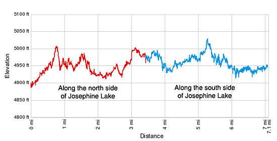
Elevation Profile
Driving Directions
To the Many Glacier Picnic Area:
From St. Mary: Drive north on US 89 for 8.5 miles and turn left onto Route 3, signed for Many Glacier. The turn is just before the town of Babb, MT. Continue along Route 3 for 11.9 miles to the Grinnell Glacier trailhead at the Many Glacier Picnic area, located on the left (south) side of the road.
From the Many Glacier Hotel Complex: Head west on Route 3 for 0.5 miles to the Grinnell Glacier trailhead at the Many Glacier Picnic area, located on the left (south) side of the road.
To the Many Glacier Hotel Complex and the Boat Dock:
From St. Mary: Drive north on US 89 for 8.5 miles and turn left onto Route 3, signed for Many Glacier. The turn is just before the town of Babb, MT. Continue along Route 3 for 11.4 miles and turn left on the road leading to the Many Glacier Hotel. In a short distance make a second left on the road leading up the hill to the large parking lot in the rear of the complex. Walk through or around the hotel to the boat dock on the west side of the building.
Via Boat: The Glacier Park Boat Company (http://www.glacierparkboats.com/) runs boat tours of Swiftcurrent Lake and Lake Josephine. Hikers can ride the boats either one way or round trip to shorten hiking distances. The two stage boat trip starts from the west side (lake side) of the Many Glacier Hotel and crosses Swiftcurrent Lake. At the end of the lake tour participants disembark and walk 400 yards to the foot of Lake Josephine where a second boat waits to take the tour to the head of Lake Josephine. At the head of Lake Josephine trails connect to destinations in the Grinnell Valley, including Grinnell Lake and Grinnell Glacier. See the Glacier Park Boat Company (http://www.glacierparkboats.com/) website for schedules and costs.
Trail Resources
Trail Intro / Trail Photo Gallery / Trail Map
Basecamp(s) Information:
Many Glacier / St Mary
Region Information:
Glacier Natl Park, MT
Other Hiking Regions in:
Montana