Details: Siyeh Pass 
Distance: 9.2 miles (round trip)
Glacier National Park, near St Mary in Glacier Natl Park, MT
Hike Facts
- Distance: 9.2 miles (round trip)
- Elevation: 5,840-ft. - 8,110-ft.
- Elevation Gain: 2,270-ft.
- Difficulty: moderate-strenuous
- Trail Highlights: See Trail Intro
- Basecamp(s): St Mary / West Glacier
- Region: Glacier Natl Park, MT
A scenic ascent of beautiful Preston Park and then a steep climb up pretty meadows and talus slopes leads to Siyeh Pass and the Baring/Boulder Divide, where stunning views unfold to the Sexton Glacier, Matahpi Peak, the Baring and Boulder Creek Valleys and beyond.
Siyeh Pass
Siyeh Pass: 9.4 miles round trip Siyeh & Piegan Pass: 13.4 miles round trip
The trailhead for Siyeh and Piegan Pass trails is located on the north side of the Siyeh Bend curve just east of where Siyeh Creek flows under the road. A brown sign, labeled Piegan Pass, marks the spot. You are actually starting on what is known as the Siyeh Bend Cut-off trail that climbs to meet the Piegan Pass trail.
From the road the Siyeh Bend Cut-off trail drops down to and travels along the right (east) side of Siyeh Creek. Straight ahead Cataract Mountain (8,180-ft.) and Mount Siyeh (10,014-ft.) rise above the head of the valley. To the left (west) Piegan Mountain (9,220-ft.) looms above the trail.
At 0.1 miles the trail turns right, curving to the southeast as it begins a moderately steep traverse through stunted pines and then thick spruce-fir forest, rock-hopping across a series of small creeks along the way. Two logs span a wide creek crossing at 1.0 mile. Rock hop across the next creek, located a short distance beyond.
Reach the junction with the Piegan Pass trail at 1.1 miles. The Piegan Pass trail to the right (south) drops downs to the Going-to-the-Sun Road. Bear left on the Piegan Pass trail toward Piegan Pass and the Siyeh Pass trail junction. The ascent continues as the trail curves to the north, crossing two more streams. Two logs facilitate the first crossing during high water. Otherwise both creeks are easily crossed on rocks without getting your feet wet.
At 1.4 miles the trail traverses a small meadow sprinkled with wildflowers. The open area provides your first views of the Going-to-the-Sun Mountain (9,642-ft.) rising above the trees to the right (east/southeast). Soon the thick forest gives way to intermittent meadows with partially obscured views of Piegan Mountain across the valley.
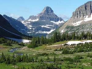
The lower slopes of Matahpi Peak (9,365-ft.), to the east, form the backdrop for a pretty creek spanned by a wooden bridge at 2.3 miles. Beyond the crossing the grade abates as the trail passes through stands of stunted trees and pretty meadows with fine views of Mt Siyeh (10,014-ft.) rising to the north, Piegan Mountain (9,220-ft.) to the west and Pollack Mountain (9,190-ft.) to the northwest.
Turn right (east) at 2.6 miles on the Siyeh Pass trail. The trail to the left (northwest) heads to Piegan Pass.
The Siyeh Pass trail ascends beautiful Preston Park on easy grades, passing through stands of subalpine larch, dwarf firs and stunted pines interspersed with lovely meadows dotted with wildflowers. The meadows afford great views of Mt. Siyeh rising above the north side of the valley and Matahpi Peak to the south. Behind you, to the west, Piegan Mountain fills the skyline. Soon views open to Siyeh Pass, the saddle on the ridge at the east end of the valley.
At 2.9 miles the trail passes to the north of a tarn and then makes a brief jog to the north before resuming its easterly course. Reach a wide, rushing stream at 3.3 miles. Wade or rock hop across the stream which drains a small lake cradled beneath the southern flanks of Mt. Siyeh.
Past the stream crossing the trail starts a steep climb up the northern slopes of Matahpi Peak toward Siyeh Pass, traversing meadows and talus slopes along the way. A few switchbacks facilitate the ascent. As you climb, enjoy ever improving views of Mt. Siyeh rising above the north side of the valley. To the west, Reynolds (9,125-ft.), Piegan and Pollack Mountains form a stunning backdrop for Preston Park’s gorgeous meadows and krummholz.
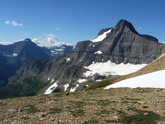
At 4.2 miles the trail travels above and to the south of Siyeh Pass (7,750-ft.), the grassy saddle on the ridge between Mt. Siyeh and Matahpi Peak. Continue following the trail as it ascends switchbacks up steep talus slopes toward the Baring/Boulder Creek Divide. As you climb, views open to the Boulder Creek Valley to the east of Siyeh Pass.
Reach the Divide (8,110-ft.), marked by a large rock cairn, at 4.6 miles. A knife-edge ridge rises above the divide to the east. The Boulder Creek Valley extends northeast below the Divide. Matahpi Peak soars overhead.
For the best views continue over the divide for a short distance. Soon views open to Sexton Glacier cradled in a bowl along the southeastern flanks of Matahpi Peak. Going-to-the-Sun rises to the south of Matahpi Peak. From this vantage point vistas extend south down the Baring Creek Valley to the west end of St. Mary Lake. Little Chief Mountain (9,541-ft.) and Mahtotopa Mountain (8,672-ft.) tower above the south side of the lake.
Most hikers turn around at the Divide, retracing their steps to the trailhead or, if time and weather permit, return to the trail junction and hike to Piegan Pass. Total round trip distance to hike to both Siyeh and Piegan Pass is 13.4 miles.
Another popular option is to continue over the Divide and descend steeply down the eastern side of the Baring Creek Valley, losing 3,440-ft. as the trail drops to and passes along the eastern rim of Sundrift Gorge. The trail ends at the Sunrift Gorge trailhead on the Going-to-the-Sun Road, 10.1 miles from the Piegan Pass/Siyeh Bend trailhead. At the Sunrift Gorge trailhead, catch a shuttle bus back to your car at Siyeh Bend. See the Siyeh Bend to Sunrift Gorge trail description for more information.
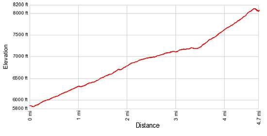
Elevation Profile
Driving Directions
From St. Mary, MT: From the intersection of Highway 89 and the Going-to-the-Sun Road in St. Mary, drive west on the Going-to-the-Sun Road for 15.2 miles to Siyeh Bend, a prominent hairpin curve on the road, 2.8 miles east of Logan Pass. Limited parking is available at pullouts on the east and west sides of the road on either side of the sharp curve. The Piegan/Siyeh Pass trailhead is located on the northeast side of the curve to the east of where Siyeh Creek flow under the road.
From West Glacier, MT: From the junction of US-2 and the Going-to-the-Sun Road, turn northwest on the Going-to-the-Sun Road and follow the road 2.0 miles to a junction with the Camas Road leading to the Apgar Visitor Center. Turn right to continue on the Going-to-the-Sun Road. Follow the road for 32.8 miles to Siyeh Bend, a prominent hairpin curve on the road, 2.8 miles down the east side of the divide from Logan Pass. Limited parking is available at pullouts on the east and west sides of the road on either side of the sharp curve. The Piegan/Siyeh Pass trailhead is located on the northeast side of the curve to the east of where Siyeh Creek flow under the road.
Glacier National Park Shuttle Bus: The Glacier National Park Shuttle bus, which operates from the beginning of July through the first week of September (check current schedule on the park’s website: http://www.nps.gov/glac/planyourvisit/shuttles.htm), runs in two sections. On the west side the buses run from Apgar Visitor Center to Logan Pass. The east side shuttle runs from the St. Mary Visitor Center to Logan Pass. Siyeh Bend is stop 6 on the east side shuttle going up from St. Mary and the first stop going down from Logan Pass.
Trail Resources
Trail Intro / Trail Photo Gallery / Trail Map
Basecamp(s) Information:
St Mary / West Glacier
Region Information:
Glacier Natl Park, MT
Other Hiking Regions in:
Montana