Details: Wijiji Trail 
Distance: 3.8 miles (round trip)
Chaco Culture National Historic Park, near Chaco Canyon in Northwest New Mexico
Hike Facts
- Distance: 3.8 miles (round trip)
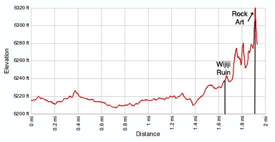
- Elevation: 6,215-ft. - 6,320-ft.
- Elevation Gain: 105-ft.
- Difficulty: easy
- Trail Highlights: See Trail Intro
- Basecamp(s): Chaco Canyon
- Region: Northwest New Mexico
This nice, short hike visits Wijiji, a late-period Chaco great house, along with an alcove with pictographs and petroglyphs.
To Wijiji Ruin
Wijiji is one of the four backcountry trails in Chaco Culture National Historic Park (Chaco Canyon). The trail starts at a pullout along the east side of the main park road, near the campground. (See driving directions below.) Before setting out on your hike fill out a free hiking permit available at the trailhead kiosk near the pullout.
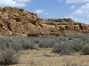
From the trailhead a boot beaten path heads southwest paralleling the Wijiji Mesa to the east. Bear left onto the Sargent Ranch Road after hiking a little over a tenth of a mile. The trail travels along the dirt road as it curves to the south and then west, entering Chaco Canyon at 0.4 miles.
The trail now heads up the northeast side of the canyon, defined by Wijiji Mesa to the left (northeast) and Chacra Mesa to the right (southwest). Be aware that you will be sharing the road with bikes. At 1.6 miles a wide trail takes off to the left (northeast) to the ruins.
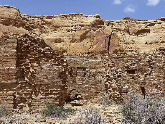
Wijiji originally had about 325 rooms arranged in a very symmetrical C-shape design. The building was terraced with the northern row of rooms rising to three stories, the next row two stories and the row facing the plaza one story. There were two small kivas, one in each wing. Unlike other Great Houses in the Chaco area there were no rooms enclosing the plaza and the site lacks a trash midden. The missing trash midden and the open plaza suggest that Wijiji was never finished.
At the northeast corner of the ruins a trail leads across the mesa and then climbs a rocky slope to an alcove at the base of the cliff with petroglyphs and pictographs. Please treat all ruins and rock you encounter with respect. Never touch the rock art, take tracings or add modern additions.
Elevation Profile
Driving Directions
From Bloomfield, NM: Head south on US 550 S for 39 miles and turn right on County Road 7900. The turn is 3 miles southeast of Nageezi and is marked with a large brown sign. Follow CR 7900 for 5.1 miles and then turn right onto County Road 7950, signed for Chaco Canyon. Travel on CR 7950 for 15.9 miles to the park boundary. Note. After turning off US 550, the first 8 miles of the route is paved and the next 13 miles are on rough dirt road. The final 4.5 miles of CR 7950 before entering the park are very rough.
Upon entering the park the road surface turns from dirt to pavement. Follow the road for 1.25 miles to a pull out on the left (east) side of the road. This is the trailhead for Wijiji. If you reach the campground entrance you have missed the trailhead.
From the campground: A foot trail heads southwest from near the campground kiosk to the trailhead.
From the Visitor Center: Turn left onto the main park road and drive 1.25 miles and park at the pull out on the right (east) side of the road. The pull out is a quarter mile past the campgound entrance.
Trail Resources
Trail Intro / Trail Photo Gallery / Trail Map
Basecamp(s) Information:
Chaco Canyon
Region Information:
Northwest New Mexico
Other Hiking Regions in:
New Mexico