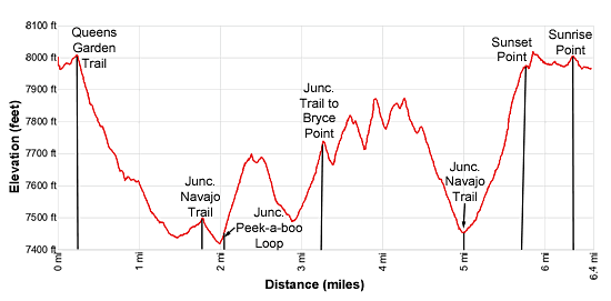
Details: Figure 8 Loop - Queens Garden, Peek-a-boo and Navajo Trails 
Distance: 6.4 miles (loop)
Bryce Canyon National Park, near Bryce in South Central Utah
By: Diane Greer
Hike Facts
- Distance: 6.4 miles (loop)
- Elevation: 8,000-ft. - 7,400-ft.
- Elevation Gain: -600-ft.
- Difficulty: moderate-strenuous
- Trail Highlights: See Trail Intro
- Basecamp(s): Bryce
- Region: South Central Utah
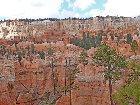
The best hike in Bryce, the Figure 8 Loop, combines the Queens Garden, Peek-a-Boo Loop and the Navajo trails for a memorable day with up-close encounters and epic views of an amazing variety of hoodoos, pinnacles and fins eroded into weird and wonderful formations.
Queens Garden Trail
Distance from Trailhead: 1.8 miles (one way)
Ending/Highest Elevation: 7,490-ft.
Elevation Gain: -510-ft.
Note: The complete Figure 8 Loop elevation gains and losses are over 1,600-ft.
The Figure 8 Loop visiting the Queens Garden, the Peek-a-boo Loop, the Navajo trails and the Rim Trail between Sunset and Sunrise Points can be accessed from either Sunrise or Sunset Point. This description starts the hike at Sunrise Point. (See driving directions below.)
From the parking lot/shuttle bus stop at Sunrise Point, walk east toward the rim. Turn right (south) when you reach the Rim Trail. The Rim Trail features fine views of the multi-hued hoodoos, spires, fins and ridges of Bryce Canyon. Boat Mesa, a long slender peninsula, juts into the canyon to the north while Bristlecone Point (7,796-ft.) rises to the northeast.
At 0.2 miles reach the junction with the Queen Garden trail, branching left (east). Ahead is Sunrise Point, a stunning overlook above the Queens Garden. Turn left and follow the Queens Garden Trail, a broad, hard packed trail descending on moderately-steep grades down the spine of a ridge. Along the way enjoy fine views of the colorful rock formation and ridges in the canyons below the trail and beneath the rim to the south.
After half a mile the trail drops down a series of switchback and then turns southeast, continuing the descent along the ridge to a junction with the horse trail, branching left (east), at 0.7 miles. We continue on the Queens Garden trail.
A short distance past the intersection the trail turns west and drops down switchbacks before crossing two low ridges. Along the way the path travels through tunnels chiseled through fins. Weird and wonderful rock formations jut from the ridges along the trail.
After passing through the third tunnel reach a junction at 0.9 miles with a spur trail branching right toward the Queen Victoria formation. The 0.1 mile (round-trip) detour takes you through a garden of fins, hoodoos and spires to the queen, located along a tall fin eroded into pinnacles. The pinnacle on the left side of the formation seems to be wearing a crown and gesturing toward the other formations in the garden. (Use your imagination to see the likeness.)
At this point you can either return to the trailhead for a 2.0 miles round-trip hike or continue down the Queens trail toward the junction with the Navajo Trail.
To continue toward the Navajo trail, return to the junction and continue descending the Queens Garden Trail through scattered trees into Bryce Canyon. The trail heads generally south and then southwest. As you near the canyon bottom nice view open to formation along the rim around Inspiration Point to the southwest.
At 1.75 miles reach a four-way junction. To the right (north) is the Navajo Trail ascending to the rim at Sunset Point. Straight ahead (west) is the Wall Street leg of the Navajo Loop which is now closed due to a rock slide. (You can go 0.3 miles up the trail to see the slide.) We turn left on the trail heading toward Peek-a-boo Loop.
Peek-a-boo Loop
Distance from Trailhead: 4.8 miles (one way)
Ending/Highest Elevation: 7,800-ft.
Elevation Gain: 1,030-ft.
Our trail now descends to and crosses Bryce Canyon’s broad wash. Beyond the wash the trail turns left (east) and travels through scrub and trees to a junction with the horse trail, branching left (northeast). We turn right toward the Peek-a-boo Loop, reaching the start of the loop at 2.0 miles.
You can hike either direction on the loop. I typically turn left here, hiking the Pee-a-boo Loop in a clockwise direction. The path now ascends steeply up the ridge separating Bryce and Peek-a-boo canyons. Along the way the trail climbs by interesting rock formations and enjoys fine views of Boat Mesa and the hoodoos along the rim. Near the top of the ridge views open to the Fairy Castle Rock formation.
As you crest the ridge the trail passes by a large standalone hoodoo and terrific views open to a sea of hoodoos, pinnacles and fins beneath Bryce point and along Peek-a-boo Canyon. The trail now zig-zags down the ridge, travels through a tunnel at 2.5 miles and then crosses Peek-a-boo Canyon’s wash at 2.8 miles. Beyond the wash the path climbs along the east side of Peek-a-boo Canyon. As you ascend great views open to the Wall of Windows and a labyrinth of rock formation at the head of the canyon.
At 3.2 miles reach a junction with the trail to Bryce Point branching left (east). We continue on the loop trail, which passes a horse corral and watering trough at 3.3 miles. You will also find pit toilets in this area.
Past the corral the trail turns right (west/northwest) and curves around the head of the canyon through a corrugated landscape of minor ridges and gullies. Eroded rock formations along the rim tower overhead. Closer at hand are the formations lining the gullies carrying meltwater from the rim. At 3.5 miles the trail passes directly beneath the Wall of Windows, a massive fin topping the ridge rimming the canyon’s western wall
At 3.7 miles the trail turns left (north) and climbs through a maze of formations, passing through a tunnel on its way to the top of a ridge. The path now travels high above the west side of Peek-a-boo Canyon, crossing a minor ridge before ascending to and crossing the ridge separating Peek-a-boo and Bryce Canyons at 4.2 miles. Here wonderful views open to the formations along the rim to the southeast of Inspiration Point. The Cathedral, an aptly named formation, towers above the trail to the right (east).
The path now descends along the east side of Bruce Canyon with fin views of Silent City to the north. Soon the trail curves to the northeast, dropping down switchbacks to the end of the Peek-a-boo Loop at 4.75 miles. Turn left toward the Navajo Trail and then left again at the junction with the horse trail.
Navajo Trail and Completing the Loop
Distance from Trailhead: 6.4 miles (loop)
Ending/Highest Elevation: 8,000-ft.
Elevation Gain: 600-ft.
The path now ascends Bryce Canyon, crosses the wash and reaches the junction with the Navajo Trail and Queens Garden trail to 5.0 miles. At the junction, head north up the Navajo Trail toward Sunset Point. The trail to the left (west) is the Wall Street leg of the Navajo trail that is closed 0.3 miles ahead due to a rock slide. To the right is the Queens Garden Trail.
The Navajo Trail to Sunset Point climbs through interesting rock formations, gaining over 480-ft. in half a mile. AT 5.25 miles the trail passes a short spur trail to Two Bridges, a double bridge, and then climbs a series of well-constructed switchbacks. The final leg of the ascent is along the north side of a ridge features fine views of Thors Hammer, the Three Gossips, Boat Mesa, and Bristlecone Point.
The grade abates at 5.5 miles as the trail reaches a junction with the Wall Street Trail. You can walk a short distance along the Wall Street Trail to the closure. Here steep switchbacks drop down a narrow corridor lined with massive fins.
When your done looking into the abyss, return to the rim and enjoy the views from Sunset point before turning north and following the Rim Trail back to Sunrise Point and then the trail leading back to your vehicle for a memorable 6.4 miles hike.
When you are done looking into the abyss, a short climb leads to the rim and Sunset Point with stunning views of Silent City and the Bruce Canyon Amphitheater. After taking in the views, proceed north on the Rim Trail back to Sunrise Point at 6.2 miles. This scenic section of the Rim features terrific views of the Queens Garden amphitheater a well as Boat Mesa and Bristlecone Point. From Sunrise Point it is 0.2 miles back to the parking area/shuttle bus stop for a memorable 6.4mile hike.
Elevation Profile
Driving Directions
From the Bryce Canyon Visitor Center to Sunrise Point: From the Visitor Center, located along UT 63, head south on UT 63 for 0.5 miles and then turn left onto the Sunrise Point access road. Follow the access road for 0.5 miles and turn left toward the Sunrise Point parking area. There are parking spots along the side of the access road and a small lot near the trailhead. More parking is located near the General Store. These parking lots fill early in the day during the height of the tourist season.
Alternatively, take the Park Shuttle Bus to the Sunrise Point stop (stop 8). The buses run every 10-15 minutes from April to October. The shuttle bus parking lot is located along UT 63, a short distance past Ruby’s Inn (in the hotel area). Limited parking is also available at the Bryce Visitor Center (stop 1), located 2.4 miles from the parking area.
From Bryce Canyon Visitor Center to Sunset Point: From the Visitor Center, located along UT 63, head south on UT 63 for 1.2 miles and then turn left onto the Sunset Point access road. Follow the access road for 0.3 miles to the end of the road and the parking area. A number of trail head east/southeast to the rim. The trail directly to Sunset Point is at the southeast end of the parking lot. Note: The parking lot fills early in the day during the height of the tourist season.
Alternatively, take the Park Shuttle Bus to the Sunset Point stop (stop 6). The buses run every 10-15 minutes from April to October. The shuttle bus parking lot is located along UT 63, a short distance past Ruby’s Inn (in the hotel area). Limited parking is also available at the Bryce Visitor Center (stop 1), located 2.4 miles from the parking area.
Trail Resources
Trail Intro / Trail Photo Gallery / Trail Map
Basecamp(s) Information:
Bryce
Region Information:
South Central Utah
Other Hiking Regions in:
Utah