Details: Aztec Butte 
Distance: 0.9 - 1.7 miles (round trip)
Island in the Sky District, Canyonlands National Park, near Canyonlands in Southeast Utah
By: Diane Greer
Hike Facts
- Distance: 0.9 - 1.7 miles (round trip)
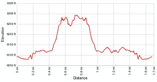
- Elevation: 6,095-ft. - 6,300-ft.
- Elevation Gain: 205-ft.
- Difficulty: moderate
- Trail Highlights: See Trail Intro
- Basecamp(s): Canyonlands / Moab
- Region: Southeast Utah
A steep climb up a slickrock dome leads to ancestral Puebloan granaries and outstanding views of Taylor Canyon.
Aztec Butte Trail
From the parking area the sandy trail heads northeast on easy grades through desert scrub, passing to the right (south) of the first sandstone dome. After walking just over 0.3 miles the trail reaches a “Y” intersection. The path branching to the left climbs the first dome while the trail to the right heads toward Aztec Butte. Bear right, continuing along the main trail as it ascends on gentle grades toward Aztec Dome.
At 0.5 miles follow a cairned trail that climbs up the moderately steep slickrock slopes on the west side of Aztec Butte. Soon the grade steepens and the narrow trail becomes more difficult as it ascends along ledges toward the top of the butte. Right before the top you will need to scramble up a very steep slickrock pitch and a tall ledge with some exposure. Before you tackle this part of the trail make sure you are comfortable descending this section of the trail. It is always harder coming down than going up! This is definitely not a trail for people with a fear of heights.
At the top of the butte take a breather and enjoy the birds-eye views that stretch south across the red rock canyons to the Abajo Mountains. When you are done taking in the views turn left on the trail looping around the top of the butte. Soon the path reaches the north side of the butte where panoramic vistas extend north/northeast across the deep abyss of Trail Canyon to the slickrock domes beyond. In the distance to the east are the La Sal Mountains.
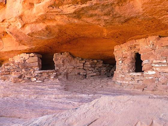
Along the north rim find the spur trail dropping down to a bench beneath the rim. Along this bench are ruins and granaries situated in the sandstone alcoves below the rim. Please do not enter any of the ruins or touch the fragile walls.
After exploring along the bench climb back to the top and continue in a clockwise direction around the loop. At the southeast end of the butte is a surface ruin composed of a rectangular room with a south facing door.
Return to the start of the loop and carefully work your way back down the west side of Aztec Butte and then follow the trail back to the “Y” intersection. At this point you have walked a little over 1 mile.
To visit the second set of ruins turn right at the junction. Soon the trail ascends slickrock slopes and ledges on moderate grades to the top of the smaller butte. As you reach the top the grade abates. The path now follows a gently ascending traverse along the north side of the butte. At 1.2 miles rock cairns mark where the trail climbs down to a ledge beneath the north rim where two granaries are tucked in a small alcove. Again, please do not enter the ruins or touch the fragile walls.
When you are done exploring the ruins retrace your steps back to the “Y” intersection and turn right to head back to the trailhead. Total round trip distance to visit both buttes is 1.7 miles. The out and back hike to the smaller of the two buttes is 0.9 miles.
Elevation Profile
Driving Directions
From Moab: Head north on US 191 N (Main Street) for 11 miles and turn left (west) onto UT 313 W. Follow UT-313 W for 14.6 miles to the “Y” intersection where UT-313 turns left. Continue straight ahead on the Grand View Point Rd / Island in the Sky Road for 13.1 miles and turn right on the Upheaval Dome Road. Follow the Upheaval Dome Road for 0.8 miles to the Aztec Butte trailhead, located on the right side of the road.
Trail Resources
Trail Intro / Trail Photo Gallery / Trail Map
Basecamp(s) Information:
Canyonlands / Moab
Region Information:
Southeast Utah
Other Hiking Regions in:
Utah