Details: Chesler Park 
Distance: 5.4 - 10.9 miles (loop)
Needles District, Canyonlands National Park, near Canyonlands in Southeast Utah
By: Diane Greer
Hike Facts
- Distance: 5.4 - 10.9 miles (loop)
- Elevation: 5,120-ft. - 5,706-ft.
- Elevation Gain: 526-ft. - 1,188-ft.
- Difficulty: strenuous
- Trail Highlights: See Trail Intro
- Basecamp(s): Canyonlands
- Region: Southeast Utah
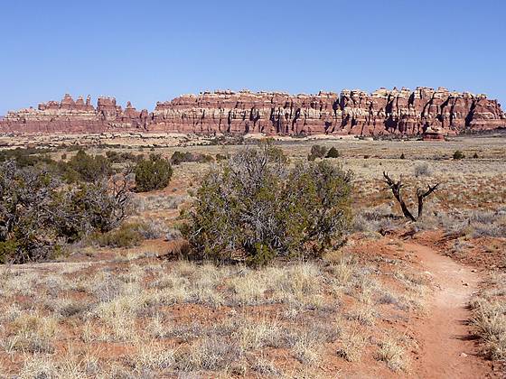
A long, entertaining circuit through a stunning landscape of sandstone spires, pinnacles, knobs, fins and monoliths surrounding a scenic expanse of desert grassland in the Needles District of Canyonlands National Park.
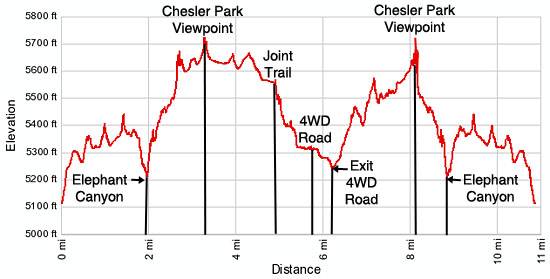
Trailhead to Chesler Park Overlook
Distance from Trailhead: 5.4 miles (round trip)
Ending/Highest Elevation: 5,646-ft.
Elevation Gain: 526-ft.
The trailhead for Chesler Park is located at the southwest end of the Elephant Hill parking area (see driving directions). Just beyond the Elephant Hill trailhead bulletin board the path climbs steeply up a stone steps and ledges before heading south along a sandstone bench. Stunted pinion pines, junipers and sage grow in the thin soils covering sections of the bench. To the right (west) of the trail are impressive terracotta and white banded sandstone fins, pillars, knobs and sculpted monoliths, a preview of the coming attractions.
Follow the trail as it curves around the heads of two side canyons (to the east) and weaves through openings in the sandstone formations to a great viewpoint, a little over a mile from the trailhead. Here expansive views of the Needles, a conglomeration of sculpted rock pinnacles, knobs and fins, open to the south.
The trail now ascends on easy grades across a scrub covered landscape to a split in the trail at 1.3 miles. Continue straight ahead on the trail to Chesler Park. (The path to the left leads to the Squaw Flats Campground.)
Past the junction the trail travels between sandstone knobs and turns southwest. In a short distance the trail swings left, squeezing through a slot between sandstone blocks, and then descends a beautiful water chiseled gorge to a viewpoint overlooking Elephant Canyon.
Beyond the viewpoint the trail drops steeply down a series of ledges and sandy slopes to the floor of Elephant Canyon, 1.9 miles from the trailhead. Cross the Elephant Canyon wash and arrive at a second junction where the trail to Chesler Park continues straight ahead, climbing moderately steep grades up a narrow scenic canyon. (The trail to the left heads up Elephant Canyon to Druid Arch.)
At the canyon rim the grade eases as the trail continues its ascending traverse across a sandstone bench, scattered with scrub growth, pinion pines and junipers. Amazing views extend west to Hell’s Kitchen, where a dense collection of tall sandstone spires tower above a sea of mushroom shaped knobs. Straight ahead is a wall of colorful sandstone pinnacles. The La Sal Mountains rise in the distance to the southeast.
Continue along the boot beaten path to the base of the pinnacles where the trail splits. To the right (northwest) is the trail to Hell’s Kitchen. The path branching to the left (southwest) leads to Chesler Park.
Bear left on the Chesler Park trail, following the path up a steep, rocky slope to a pass (5,640-ft.) between two of the pinnacles, 2.8 miles from the trailhead. The scenic pass, known as the Chesler Park Viewpoint, is located at the northeast end of Chesler Park.
From the viewpoint enjoy panoramic vistas of beautiful Chesler Park, a scenic expanse of desert grasses and shrubs surrounded by stunning multi-hued sandstone spires, pinnacles and knobs. For the best view of Chesler Park I recommend dropping down a short distance from the pass and then climbing a low sandstone bench to the left (east) of the trail.
Overlook to the Joint Trail
Distance from Trailhead: 10.0 miles (round trip)
Ending/Highest Elevation: 5,706-ft.
Elevation Gain: 588-ft.
The viewpoint is a good turnaround point if you are looking for a short hike (5.4 miles round trip). But the best scenery is yet to come. So if you have the time and energy continue descending from the pass to a trail junction at 2.9 miles. As you descend be sure to look for an arch and two small windows high on the sandstone fin to the right (east) of the trail.
The junction marks the beginning of the loop around Chesler Park, which can be hiked in either direction. To the left (southeast) is a trail to the Joint, which traverses the eastern side of the park. To the right (west) is the trail to the Devil’s Kitchen that travels along the northern side of the park. I recommend turning left toward the Joint and using the path to the left on the return leg of the loop.
Turn left and follow the trail as it ascends on easy grades to the southeast, paralleling an impressive wall of sandstone fins. Along the way enjoy ever improving views of Chesler Park. Pass a spur trail to the left leading to Chesler Park campsite #1 and continue along the sandy trail to an unmarked spur trail on the left, at 3.3 miles. Follow the short spur to an opening between two fins with great views of the colorful sandstone column towering above Elephant Canyon’s northeast wall.
After taking in the view return to the main trail, which now swings right (southwest), descending on gentle grades toward an impressive sandstone formation of pinnacles and knobs rising in the middle of the Park. Just before reaching the formation arrive at a junction with a trail branching left (east) toward Druid Arch, 4.0 miles from the trailhead. Continue straight ahead at the junction. Soon the trail passes between two of the sandstone knobs. Just beyond the knobs is a spur trail heading right (north) to Chesler Park campsites #3, #4 and #5, nestled along the west side of the formation. Campsite #2 is located in the huge boulders to the left (south) of the trail.
The trail continues its southwestern traverse through desert grasslands toward the huge wall of sandstone columns and pinnacles rising above the southwestern end of the Park. At 4.4 miles the trail curves to the right (northwest), paralleling the wall. Great views along this section of the trail encompass the amazing rock formation in the center of the park, the imposing sandstone wall to the southwest and the sea of pinnacles and spires to the northwest.
Reach the junction with the Joint trail at 4.8 miles. Here a short spur trail to the left (south) leads to the Chesler Park Overlook, a scenic viewpoint on a rocky knob with stunning vistas of the park. I highly recommend this side trip to the overlook, which is a great spot for taking a break and enjoying the panoramic views of the Park.
After taking in the views return to the trail junction and drop down into the Joint, an entertaining traverse through a series of deep, narrow fractures in the Cedar Mesa Sandstone. (People uncomfortable in confined spaces will want to avoid this section of the trail.) Follow the trail as it heads southwest through a succession of widening fissures for 0.2 miles and then turns west, passing through a short chamber decorated with rock cairns in all conceivable shapes and sized before finally emerging rather abruptly into the bright sunshine.
Some people turn around at this point and head back to the trailhead for a 9.8 miles round trip hike. I recommend doing the entire loop.
Completing the Loop
Distance from Trailhead: 10.9 miles (loop)
Ending/Highest Elevation: 5,647-ft.
Elevation Gain: 1,188-ft.
To continue on the loop follow the trail as it heads north/northwest, descending a narrow, scenic canyon on moderate grades. At 5.4 miles the trail swings left (west/southwest) and drops steeply down a series of ledges to a sandy wash. Cross the wash and look for the rock cairn on the other side marking the continuation of the trail climbing a low hill. Cross the hill and arrive at a cul-de-sac on the 4WD road at 5.7 miles. Near the junction you will find a picnic table and outhouse.
Turn right on the 4WD road and walk northwest for 0.5 miles to a junction. To the left is the 4WD road leading to Beef Basin. We turn right (northeast) and continue along the road for a quarter mile (0.25-miles) to a trail junction at 6.4 miles. Turn right on the trail signed for “Chesler Park, foot travel only”. Note this sign is setback about 15-20-ft. from the road.
The trail ascends on moderate to moderate-steep grades through a landscape of knobs and mushroom shaped rocks to a signed junction with the trail to the Devil’s Kitchen, which turns left (north), at 6.8 miles. Turn right (east) toward Chesler Park.
Follow the trail, marked with rock cairns, over a sandstone bench, across a minor drainage and then up a series of ledges to a sparsely vegetated bench. Massive fins and needles tower over the trail to the north while to the south/southeast is a sea of sandstone pillars and domes. Pay close attention to the cairns along this circuitous section of the trail. It is easily to be distracted by the great scenery and miss a turn.
The trail now heads across the bench, passes between two rock domes and soon arrives at a wonderful overlook with great views of Chesler Park. Beyond the viewpoint the trail crosses a minor drainage, weaves around granite domes and slabs and then follows an ascending traverse across sandy, scrub covered flats to the junction where you started the loop around Chesler Park, 8 miles from the trailhead.
Turn left at the junction and retrace your steps back to the Chesler Park trailhead by following signs to Elephant Hill. The total distance for this great loop hike is 10.9 miles.
Elevation Profile
Driving Directions
From Moab: Drive south on U.S. Highway 191 for roughly 40 miles to Utah Highway 211 (signed for Canyonlands National Park, Needles District) and turn right (west). Follow Utah Highway 211 west for 37.2 miles and turn left (west), on the road signed for the Squat Flat Campground. The turn is located 2.8 miles beyond the Visitor Center.
Drive 0.3 miles to the first intersection and turn right onto the Squaw Flat Campground B road. At the next intersection, reached in 0.2 miles, continue straight ahead. (The road is signed for Elephant Hill.) Follow the rough, winding one-lane dirt road for 2.7 miles to the trailhead parking area. The trailhead is located at the southwest end of the parking lot.
From Monticello: Drive north on U.S. Highway 191 for roughly 14.3 miles to Utah Highway 211 (signed for Canyonlands National Park, Needles District) and turn left (west). Follow Utah Highway 211 west for 37.2 miles and turn left (west), on the road signed for the Squat Flat Campground. The turn is located 2.8 miles beyond the Visitor Center.
Drive 0.3 miles to the first intersection and turn right onto the Squaw Flat Campground B road. At the next intersection, reached in 0.2 miles, continue straight ahead. (The road is signed for Elephant Hill.) Follow the rough, winding one-lane dirt road for 2.7 miles to the trailhead parking area. The trailhead is located at the southwest end of the parking lot.
From Blanding, UT: Drive north on U.S. Highway 191 for roughly 34.8 miles to Utah Highway 211 (signed for Canyonlands National Park, Needles District) and turn left (west). Follow Utah Highway 211 west for 37.2 miles and turn left (west), on the road signed for the Squat Flat Campground. The turn is located 2.8 miles beyond the Visitor Center.
Drive 0.3 miles to the first intersection and turn right onto the Squaw Flat Campground B road. At the next intersection, reached in 0.2 miles, continue straight ahead. (The road is signed for Elephant Hill.) Follow the rough, winding one-lane dirt road for 2.7 miles to the trailhead parking area. The trailhead is located at the southwest end of the parking lot.
Trail Resources
Trail Intro / Trail Photo Gallery / Trail Map
Basecamp(s) Information:
Canyonlands
Region Information:
Southeast Utah
Other Hiking Regions in:
Utah