Beards Wheatfield 
Distance: 6.8 - 8.2 miles (round trip)
Jedediah Smith Wilderness, Targhee National Forest, near Driggs in The Tetons
By: Diane Greer
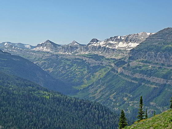
Peaks and ridges rising above the South Fork
Great views of the Tetons and the peaks rimming the North and South Fork of Teton Canyon are the highlights of this off-the-beaten path trail climbing steeply up the north slopes of the North Fork to the ridge crest. Extend the hike by following a use trail along the panoramic ridge.
See Trail Detail/Full Description
- Distance: 6.8 miles (round trip) to Beards Wheatfield
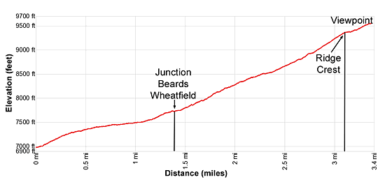
- Elevation: 6,950-ft. at Trailhead
9,550-ft. at Beards Wheatfield - Elevation Gain: 2,600-ft. to Beards Wheatfield
- Difficulty: strenuous
- More Hikes in:
Driggs / Jackson / The Tetons
Why Hike Beards Wheatfield
Most people hiking up the North Fork of Teton Canyon are heading to Table Mountain. Hikers looking for views and solitude will find the Beards Wheatfield trail an interesting alternative. The path climbs steep switchbacks up the canyon’s north slopes to the ridge crest and then follows a use trail along the crest.
The hike up to and then along the ridge crest features fabulous views of the summits towering above the North and South Fork of Teton Canyon. The signature Teton peaks, including the summits of Mount Owen, Grand Teton, Middle Teton and South Teton, form the backdrop to the amazing scene. Other views from the ridge include Fred’s Mountain, to the northwest, and the summits of the South Leigh, Granite and Green Lakes valleys to the north/northeast.
Elevation Profile
Trail Resources
Trail Detail/Full Description / Trail Photo Gallery / Trail Map
Basecamp(s) Information:
Driggs / Jackson
Region Information:
The Tetons
Other Hiking Regions in:
Wyoming