Taylor Mountain 
Distance: 7.7 - 8.8 miles
Targhee National Forest, near Jackson Hole in The Tetons
By: Diane Greer
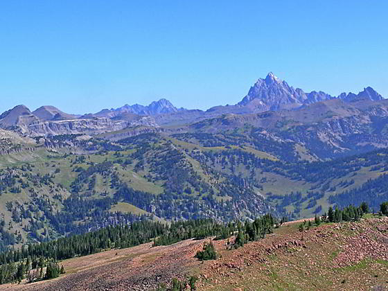
View from the first summit
Wildflowers and far reaching views of the high peaks in the Tetons, Gros Ventre, Snake River and Big Hole Ranges are the highlights of this scenic trail ascending the beautiful meadows of the Coal Creek Valley before climbing to the summit of Taylor Mountain.
- Distance: 7.7 - 8.8 miles (RT)
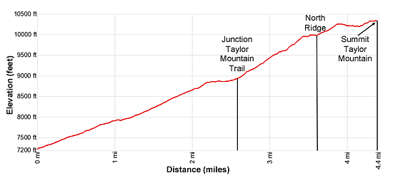
- Elevation: 7,250-ft. at Trailhead
Maximum elevation - 10,352-ft. - Elevation Gain: 3,102-ft.
- Difficulty: strenuous
- Basecamp: Jackson / Driggs
- Region: The Tetons
Trail Description - Taylor Mountain
Taylor Mountain is known for its 360-degree views encompassing the summits of the Teton Range to the north, the Snake River and Salt River ranges to the south, the Gros Ventre Range to the east/northeast and the Big Hole Mountains rising beyond the Teton Valley in Idaho to the west/northwest. The hike to the summit ascends the flower-filled meadows of the Coal Creek Valley before a steep, one-mile climb to Taylor Mountain’s north ridge. From the ridge a rocky trail ascends southwest to the summit.
This trail is not nearly as crowded as nearby hikes in Grand Teton National Park, although the first section of the hike up the Coal Creek valley is popular with locals looking for a short hike. Most hikers ascend to the head and the valley and then turn around. Far fewer climb to Taylor’s summit.
Hikers not comfortable walking along the rocky north ridge path to the summit can instead visit a lower summit adjacent to the point where the trail crests the ridge. This vantage point enjoys great views of the Teton Range along with views of Rendezvous Peak and the high ridge to the south of Moose Lakes. Keep in mind that views to the south from this overlook are obstructed by Taylor Mountain’s summit.
The trail to Taylor Mountain begins at the northwest side of the Coal Creek trailhead parking area (see directions below). The path follows the Coal Creek Trail that heads northwest and soon crossed Coal Creek on a good bridge. Past the bridge the trail curves to the right (north/northeast), ascending on moderate to moderately steep grades through trees and intermittent meadows above the west side of Coal Creek. At 0.25 miles the path passes into the Jedediah Smith Wilderness Area. In mid to late July (depending on the year) the meadows are awash in beautiful wildflowers.
As the trail proceeds up the valley it turns to the right (east) and then back to the left (northeast), echoing the creek’s course along the valley floor. At 0.9 miles the trees thin and soon give way to the Coal Creek meadows scattered with clusters of willows.
At 1.2 miles the path crosses to the east side of the creek and then ascends on moderate-steep to steep grades up slopes filled with wildflowers. Two switchbacks facilitate the climb up the lush slopes along the east side of the valley. As the trail gains elevation views open to Taylor Mountain, towering above the west side of the valley, and the rolling, forested hills to the south. Soon groves of aspens and patches of sage appear along the slopes.
At 1.9 miles the path starts passing through clusters of conifers. The grade levels at 2.2 miles as the trail curves to the north, traveling through a large, lovely meadow adorn with wildflowers. To the west are fine views of Taylor Mountain’s north ridge.
The trail resumes its climb at 2.5 miles, reaching the junction with the trail to Taylor Mountain branching left (west) at 2.6 mile. (Ignore the sign indicating the mileage to Taylor Basin and Moose Creek Road.) The Coal Creek trail continues straight ahead to the Mesquite Divide.
The Taylor Mountain trail now climbs steep switchbacks up the peak’s east facing slopes. The grade abates at 3.4 miles as the path curves to the left (west) beneath a minor summit and then reaches a saddle on the peak’s north ridge at 3.6 miles, gaining over 1,000-ft. from the junction.
A climb up the minor summit to the right (northeast) offers great views of the Grand Teton, Mount Moran and Fossil Mountain, to name a few, to the north. The ridge rimming the west side of the Moose Creek valley rises to the northwest while Rendezvous Mountain dominates the view to the northeast. The minor summit is a good destination for people who are not comfortable hiking further along the ridge.
At the saddle on the ridge is a junction with the continuation of the Taylor Mountain trail. This 6.4 mile long trail drops down the west side of the saddle to Taylor Basin and then descends to the Moose Creek trailhead, accessible from the Moose Creek Road to the south of Victor, Idaho.
From the junction we head southwest, following the boot beaten path that stays at or near the crest of Taylor Mountain’s north ridge. The rocky trail crosses another minor summit at 3.9 miles and then ascends to the summit of Taylor Mountain (10,352-ft.) at 4.4 miles.
The summit enjoys panoramic views in all directions. The Tetons command your attention to the north while the Gros Ventre Range rises beyond Jackson to the east/northeast. The Snake River Range fills the skyline to the south. To the west/northwest are the Big Hole Mountains of Idaho.
When you are done taking in the views retrace your steps to the trailhead for an 8.8 mile hike. For more views of the Tetons take a quick detour to Mesquite Pass, the saddle at the head of the Coal Creek Valley.
Elevation Profile
Driving Directions
From Jackson, WY: From the corner of W. Broadway and Cache Streets, at the southwest corner of the Jackson Town Square, head west Broadway (US-89 S/US-191 S/US-26 W) for 1.4 miles and then turn right onto WY-22 W (Teton Pass Highway). Follow WY-22 W for 13.8 miles. The road crosses Teton Pass at 11.1 miles and then descends for 2.6 miles to the signed Coal Creek Trailhead on the right (north) side of the road. Turn right and park in the Coal Creek Trailhead parking area.
From Driggs, ID: At the only traffic light in Driggs, located at the corner of Main Street (ID-33) and East Little Avenue, head south on Main Street (ID-33 E) for 13.9 miles, crossing the border into Wyoming. Here the road turns into WY-22 E. Continue on WY 22-E for 3.6 miles to the signed Coal Creek Trailhead on the left (north) side of the road. Turn left and park in the Coal Creek Trailhead parking area.
Trail Resources
- Trail Photo Gallery
- Trail Maps
- Basecamp(s) Information: Jackson / Driggs
- Region Information: The Tetons
- Other Hiking Regions in: Wyoming