Details: Emerald Triangle Loop 
Distance: 11.4 miles (loop)
Yoho National Park, near Yoho in The Canadian Rockies
Hike Facts
- Distance: 11.4 miles (loop)
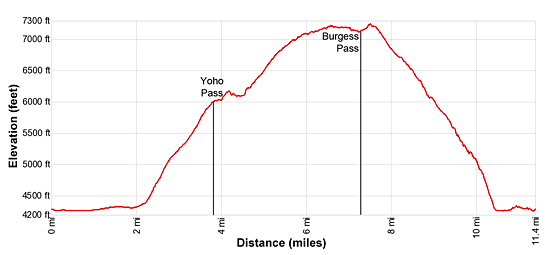
- Elevation: 4,620-ft. - 7,250-ft.
- Elevation Gain: 2,990-ft.
- Difficulty: strenuous
- Trail Highlights: See Trail Intro
- Basecamp(s): Yoho / Field
- Region: The Canadian Rockies
Stunning views of the President Range and the Emerald Lake Valley are the rewards of this interesting circuit. Along the way pass scenic Emerald Basin, travel through wildflower-filled meadows and visit Burgess Pass, with fine views of Lake O’Hara region’s high peaks.
Emerald Triangle Loop
From the Emerald Lake parking area near the Emerald Lake Lodge, walk north toward the southwest shore of Emerald Lake. Here you will find a trail kiosk and bathrooms. Follow the Yahoo Pass trail as it heads north/northeast through forest and meadows along Emerald Lake’s west shore. Yoho Pass is the low point on the ridge between Michael Peak (8,861-ft.) to the north and Wapata Mountain (9,112-ft.) to the northwest. Mount Burgess (8,525-ft.) rises to the southeast.
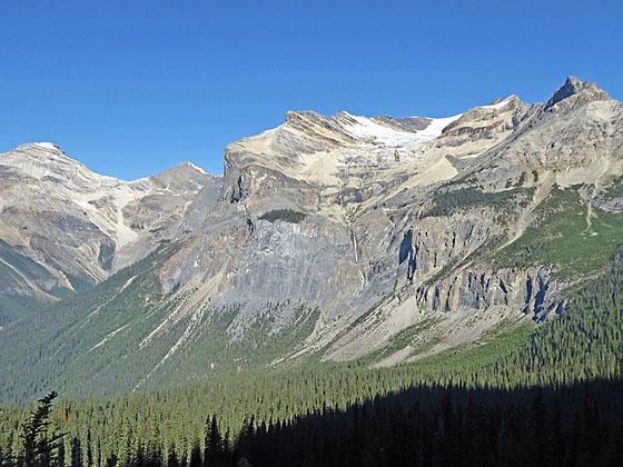
The President Range, to the north, grows in stature as you proceed along the shoreline. Soon views open to the high peaks surrounding Emerald Basin, a natural amphitheater to the north. Mt. Hurd (9,817-ft.) and Mt. Vaux (10,886-ft.) along with the Hanbury Glacier in the Ottertail Range dominate the distant views to the southwest.
At the head of the lake the trail briefly curves to the right (east) and reaches a junction at 1.0 mile. Here the trail to Emerald Basin branches left (north). We continue straight ahead on the Yoho Pass Trail. At the next junction (1.1 miles), bear left (northeast) to stay on the Yoho Pass trail. The trail to the right (east) is the Emerald Lake Loop that circles the lake.
The trail now crosses the alluvial fan created by glacial meltwater from Emerald Basin flowing into Emerald Lake. Rocks, gravel and other debris are dropped upstream while the finer silt is carried to the lakeshore creating a delta. Repeated floods and avalanche activity has cleared many of the trees from the fan, opening fine vistas of the high peaks, ridges and rugged crags surrounding Emerald Basin. Most prominent is the south ridge of the President (10,291-ft.).
Cross the alluvial fan on a boot beaten trail connected by a series of wood bridges and planks spanning meltwater streams. Over time floods have rerouted the path. Pay attention to stay on the trail. Near the north end of the fan views open ahead to a steam cascading down a rocky slope.
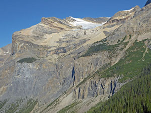
At 2.1 miles the trail starts the steep ascent to Yoho Pass, climbing timbered slopes to the east of the stream. Switchbacks facilitate the ascent. Openings in the trees offer fine views of Mt. Burgess and the Van Horne Range to the west. Soon you will see a waterfall, fed by the Emerald Glacier, plunging down the rugged slopes beneath Mitchell Peak. As you ascend, enjoy ever improving views of the falls and the President Range.
Reach a junction and forested Yoho Pass at 3.8 miles. The trail straight ahead leads to Yoho Lake and Takakkaw Falls. We turn right (south) on the Wapata Highline toward Burgess Pass. A short distance beyond is a sign with a map showing that the Highline passes beneath the western side of the Burgess Shale Fossil Beds on Wapata Mountain. This UNESCO World Heritage Site can only be visited on an organized tour. Talk to a ranger Yoho’s Field Visitor Center in Field, BC, for more information. Please stay on the trail as you pass beneath this area.
Past the sign the trail ascends through forest and at 4.1 miles emerges on the open slopes beneath the sheer cliffs along Wapata Mountain’s west facing slopes. Here the grade abates and stunning views open to the President Range. The tongue of the Emerald Glacier clings to the bowl beneath Mitchell Peak. The full extent of the falls, fed by the receding glacier, is seen plunging down rugged slopes to the valley floor.
Follow the rough and at times exposed path as it traverses beneath the cliffs. At 4.4 miles the climbs resumes on steep to moderately steep grades, crossing a series of avalanche chutes. As you gain altitude, turn around and look through the Yoho Pass gap to see Trolltinder Peak (9,533-ft.) and Mount Balfour (10,774-ft.) rising in the distance along the east side of the Yoho Valley.
At 4.9 miles the trail starts to curve to the southeast. Soon views open to Mount Burgess. The rugged crags of Wapata Mountain tower above the trail. Emerald Peak (8,418-ft.) and Mount Carnarvon (9,971-ft.) form the backdrop for Emerald Lake nestled on the valley floor.
At 5.6 miles the grade abates as the path enters the trees and ascends on moderate grades. Soon the trees thin and then give way to open slopes beneath the ridge extending between Wapata Mountain and Mount Field (8,667-ft.).
In season the hillside are awash with wildflowers. Distant views of Mount Hurd, Mount Vaux and the Hanbury Glacier are seen through the gap to the south, which is Burgess Pass. Turn around for panoramic views of the President Range and Emerald Basin.
The grade now eases and descends gently to a low ridge at 6.9 miles. Here we have some nice, albeit distant views, of the Ottertail Range. Atop the ridge the path enters the trees and ascends along or near the ridge crest.
At 7.3 miles the trail crosses to and travels along the south side of the ridge. Openings in the trees offer intermittent views of town of Field and the high peaks in the Lake O’Hara region of Yoho National Park to the southeast.
Reach a trail junction and Burgess Pass at 7.5 miles. The trail to the left (south) descends steeply to the Trans-Canada Highway across from Field, a small town. We turn right (northwest) on the Burgess Pass trail toward Emerald Lake. A short distance beyond the trail crosses back to the north side of the ridge and reaches a bare slope with great views of the President Range and Wapata Mountain.
Beyond the ridge the trail descends through meadows and trees and then viewless forest to the southeast shore of Emerald Lake at 10.2 miles. Switchbacks help ease the knee-bounding descent that seems to take forever.
The final leg of the hike travels through trees along the Emerald Lake’s south shore. The President Range, adorn with the Emerald Glacier, towers above the lake to the north. In places you can drop down to the lake and take in the scene. This section of the trail is busy with day trippers and Emerald Lake Lodge guests enjoying the views. Shortly before reaching the lodge a signs at a junction will try to steer you through forest to the parking area. Instead, bear right, heading for the lodge area. While it is crowded, you will be able to enjoy a few more sublime views of the lake and the surrounding peaks. Reach the parking area and the end of the hike at 11.4 miles.
Elevation Profile
Driving Directions
From Field, BC, Canada: Head southwest on the Trans-Canada Highway / BC-1 W for one mile and turn right (west) onto the Emerald Lake Road. Drive 5.7 miles to the end of the Emerald Lake Road and park in the large parking area at the southwest end of Emerald Lake. The parking lot is shared by day trippers visiting the nearby Emerald Lake Lodge and the Lake. The drive should take 18 minutes.
From Lake Louise, AB, Canada: Head west on the Trans-Canada Highway AB-1 W, which changes to BC-1 W upon entering British Columbia, for 16.6 miles and then turn right (west) onto the Emerald Lake Road. Drive 5.7 miles to the end of the Emerald Lake Road and park in the large parking area at the southwest end of Emerald Lake. The drive should take 38 minutes.
From Banff, AB, Canada: Head northwest on the Trans-Canada Highway AB-1, which changes to BC-1 W upon entering British Columbia, for 51 miles and then turn right (west) onto the Emerald Lake Road. Drive 5.7 miles to the end of the Emerald Lake Road and park in the large parking area at the southwest end of Emerald Lake. The parking lot is shared by day trippers visiting the nearby Emerald Lake Lodge and the Lake. The drive should take 1 hr, 12min.
Trail Resources
Trail Intro / Trail Photo Gallery / Trail Map
Basecamp(s) Information:
Yoho / Field
Region Information:
The Canadian Rockies
Other Hiking Regions in:
Alberta / British Columbia