Details: Iceline Trail 
Distance: 8.6 - 12.6 miles (loop)
Yoho National Park, near Yoho in The Canadian Rockies
Hike Facts
- Distance: 8.6 - 12.6 miles (loop)
- Elevation: 4,930-ft. - 7,310-ft.
- Elevation Gain: 2,380-ft.
- Difficulty: strenuous
- Trail Highlights: See Trail Intro
- Basecamp(s): Yoho / Field
- Region: The Canadian Rockies
One of the premier hikes in Yoho National Park features grand views of glacier clad peaks, rugged alpine landscapes and dramatic waterfalls.
Iceline to the High Point
Distance from Trailhead: 8.6 miles (round trip)
Ending/Highest Elevation: 7,310-ft.
Elevation Gain: 2,380-ft.
The Iceline Loop starts at the end of the Yoho Valley Road at the Takakkaw Falls Parking area. Walk to the east side of the parking area and then head south toward Takakkaw Falls on a wide trail traveling above the west bank of the Yoho River. Along the way enjoy great views of the Takakkaw Falls.
Takakkaw, which means “It’s magnificent” in Cree, is truly an amazing spectacle. Meltwater from the Daly Glacier, part of the Waputik Icefield, feeds the 830-ft. falls – one of the highest in Canada. The base of the falls is typically enveloped in spray, offering a great place to cool off after a long hike.
About 0.2 miles from the parking area reach the junction with a spur trail branching left (east) that crosses a bridge over the Yoho River and leads to the base of the falls. The 1.1 mile RT side trip is highly recommended.
Past the bridge the trail curves to the right (south/southwest) through trees to the Yoho Valley Road. Carefully cross the road and on the other side walk up the spur road for the Whiskey Jack Hostel (the hostel parking lot is restricted to people staying in the hostel). As the spur road curves toward the Hostel you will see a trailhead sign and a trail heading west. Take this trail which climbs steeply through forest up the west side of the valley. Intermittent openings in the forest offer views of Takakkaw Falls. Switchbacks facilitate the ascent.
At 1.2 miles pass a junction with a trail branching left (southeast) toward Hidden Lakes. Reach a second junction in 0.1 miles and bear right (northwest) on the Iceline Trail. The path straight ahead leads to Yoho Lake campground, Yoho Pass and the Emerald Lake area of Yoho National Park.
Beyond the second junction the trail climbs steep switchbacks up the west side of the valley. At 1.5 miles the path curves to the right and begins a steep, ascending traverse along the east facing slopes of the ridge running between Mitchell Peak (8,843-ft.) and the Vice President(10,056-ft.).
Soon the trees give way to stunted conifers and small shrubs. Views open to Mount Balfour (10,774-ft.) and Fairy Glacier to the northeast. Takakkaw Falls spills down the sheer rockface across the valley. Ice-polished cliffs ending in talus fields rise above the steep hillside above the trail.
At 1.9 miles reach the junction with the Highline Trail, branching left. We continue straight ahead, climbing steeply up the Iceline Trail. With each step the landscape grows more rugged as the trail ascends through debris left by receding glaciers. Small alpine plants grow amid the rock, adding color to the scene.
At 2.4 miles the grade abates as the trail reaches a high bench on the east side of the President Range. For the next two miles the trail gradually ascends along the bench on an undulating path that climbs over terminal moraines, rock ledges and outwash plains. Along the way the path crosses meltwater streams and passes small tarns. Waterfalls tumble down rock shelves and cascade through talus fields. Disconnected sections of the Emerald Glacier cling to the rugged slopes above the trail.
Glorious views extend east across the valley to Takakkaw Falls, Mt. Daly (10,328-ft.), the Daly Glacier and Waputik Ice Field. Mount Balfour and the Fairy Glacier dominate the views to the northeast while Mounts Collie (10,311-ft.), Rhonda (10,045-ft.) and Gordon (10,370-ft.) tower above the head of the Yoho valley. As you proceed along the bench views open to the Poilus Glacier clinging to the slopes of Mount McArthur (9,911-ft.) and Isolated Peak (9,261-ft.) rising above the Little Yoho Valley to the north. Soon Mount Pollinger (9,225-ft.) and Kiwetinok Peak (9,543-ft.) joins the scene.
At 3.8 miles reach the junction with the trail to Celeste Lake branching to the right (north/northeast). The junction is located along the east side of a tarn tinted with glacial flour. This Celeste Lake trail descends through meadows and then forest to the Yoho Valley, passing Celeste Lake along the way. We continue heading northwest along the Iceline, which soon passes to the east of a second tarn.
Beyond the tarns the trail climbs to the top of a moraine, reaching the high point (7,310-ft.) on the Iceline Trail at 4.3 miles. This is a good turn around point for parties looking for a shorter hike. If time and energy permit, I recommend continuing along Iceline trail and completing the loop.
Completing the Loop
Distance from Trailhead: 12.6 miles (loop)
Ending/Highest Elevation: 7,310-ft.
Elevation Gain: -2,380-ft.
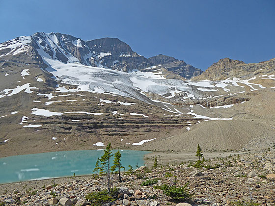
From the high point the trail descends on moderate grades, losing about 250-ft. as it drops to a turquoise tarn at the base of a bowl beneath the Vice President (10,057-ft.). The Emerald Glacier hangs from the slopes above the tarn. The summit of the President (10,293-ft.) rises beyond.
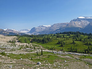
The trail now climbs to the top of second moraine where great views open northwest to the wall of peaks rimming the Little Yoho Valley including The Whaleback (8,585-ft.), Isolated Peak, Mount McArthur and Mount Pollinger. Kiwetinok Peak rises beyond the head of the valley.
The trail now turns west, descending the slopes of the moraine along the shoulder of the Vice President, high above the south side of the Little Yoho Valley. Along the way enjoy fine views of high peaks towering above the head of the valley. Soon the trail turns northwest and drops through forest toward the valley floor. Pass the junction with the trail to Kiwetinok Pass at 6.4 miles. This trail, which climbs to a scenic pass, is a worthwhile side trip for parties planning to overnight at the Little Yoho Campground or Stanley Mitchell Hut.
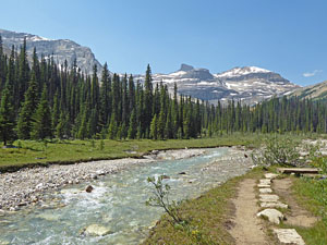
Beyond the junction the trail turns right (northeast) and soon emerges from the trees. A brief walk through meadows leads to a bridge crossing to the north side of the Little Yoho River at 6.6 miles. The meadows are a nice place to take a break and enjoy sublime views of the pretty meadow and river set against a backdrop of the peaks rising above the head of the valley.
On the north side of the river pass a trail branching left (west) toward the Little Yoho campground. Right before reaching the Stanley Mitchell hut is a trail junction and the end of the Iceline. Turn right (east) on the Little Yoho Valley Trail, which descends the north side of the valley. Initially meadows and openings in the trees offer views of the river, the President Range and Emerald Glacier. Unfortunately the trees soon thicken and we enter viewless forest.
At 8.4 miles reach the junction with the Celeste Lake Trail heading right (south/southeast) toward Celeste Lake and the Iceline. A short distance beyond is a second junction with the Whaleback trail branching left (north). Continue straight ahead at both junctions on the Little Yoho Valley Trail.
A short distance beyond the last junction the trail starts a steep descent down switchbacks toward the Yoho Valley. Pass a third junction at 8.9 miles with a trail branching left (north) toward Marpole Lake and Twin Falls. Stay straight, heading toward Takakkaw Falls via Laughing Falls.
At 9.6 miles the descent abates as the trail reaches the junction with the Yoho Valley Trail. Turn right (southeast) at the junction on the Yoho Valley Trail toward the Takakkaw Falls parking area. (Turning left (north) on the Yoho Trail leads to the Yoho Glacier.) Just beyond the junction two unmarked spur trails branch right to viewpoints for Laughing Falls, a lovely falls at the confluence of the Little Yoho and Yoho Rivers. The falls is another great place to take a break.
Past Laughing Falls the trail crosses the Little Yoho River on a wood bridge at 9.8 miles and begins a gentle descent down the forested west side of the Yoho Valley. At 10.7 miles there is a short, steep drop and then the trail continues descending the valley on gentle grades.
At 11.0 miles reach a junction with the spur trail leading right (west) to Point Lace Falls, a beautiful falls cascading down rocky ledges on Lake Duchesnay’s outlet stream. I recommend this 0.1 RT side trip. Almost immediately you will come to the junction with a second spur trail leading left (east) to an overlook on the banks of the Yoho River with views of Angels Staircase Falls tumbling down the slopes along the east side of the valley. In my opinion this is the least spectacular of the falls and can be skipped if you are feeling tired and just want to get back to the trailhead.
At 11.6 miles the trail comes abreast of the west bank of the Yoho River, tinted light blue with glacial silt. The trail, now a wide track, briefly travels beside the river before plunging back into the trees. At 12.0 miles the trees give way to gravel flats where a wood bridge spans streams carrying meltwater from the Emerald Glacier high above the valley to the west. The open flats offer nice views of Takakkaw Falls plunging down the steep cliffs to the southeast.
Reenter the trees at 12.2 miles and then walk through the Takakkaw Falls Campground. Reach the Takakkaw Falls parking lot and the end of the loop at 12.6 miles.
Elevation Profile
Driving Directions
From Field, BC, Canada: Head east on the Trans-Canada Highway BC 1 E for 2.2 miles and then turn left on the Yoho Valley Road. (Note: The road is open mid-June through mid-October. RVs and trailers are not permitted due to steep switchbacks.) Drive to the end of the Yoho Valley Road (8.4 miles) and park in the Takakkaw Falls parking area. This is a popular destination. Get an early start to ensure you get a parking spot. The drive should take about 35 minutes.
From Lake Louise, AB, Canada: Head west on the Trans-Canada Highway AB-1 W, which changes to BC-1 W upon entering British Columbia, for 13.4 miles and then turn right on the Yoho Valley Road. (Note: The road is open mid-June through mid-October. RVs and trailers are not permitted due to steep switchbacks.) Drive to the end of the Yoho Valley Road (8.4 miles) and park in the Takakkaw Falls parking area. This is a popular destination. Get an early start to ensure you get a parking spot. The drive should take about 55 minutes.
From Banff, AB, Canada: Head west on the Trans-Canada Highway AB-1 W, which changes to BC-1 W upon entering British Columbia, for 47.8 miles and then turn right on the Yoho Valley Road. (Note: The road is open mid-June through mid-October. RVs and trailers are not permitted due to steep switchbacks.) Drive to the end of the Yoho Valley Road (8.4 miles) and park in the Takakkaw Falls parking area. This is a popular destination. Get an early start to ensure you get a parking spot. The drive should take about 1 hour and 30 minutes.
Trail Resources
Trail Intro / Trail Photo Gallery / Trail Map
Basecamp(s) Information:
Yoho / Field
Region Information:
The Canadian Rockies
Other Hiking Regions in:
Alberta / British Columbia