Details: Lake O’Hara Alpine Circuit 
Distance: 4.5 - 7.5 miles (loop)
Yoho National Park, near Yoho in The Canadian Rockies
By: Diane Greer
Hike Facts
- Distance: 4.5 - 7.5 miles (loop)
- Elevation: 6,610-ft. - 8,307-ft.
- Elevation Gain: 1,697-ft.
- Difficulty: strenuous-difficult
- Trail Highlights: See Trail Intro
- Basecamp(s): Yoho / Field
- Region: The Canadian Rockies
Arguably the best day hiking trail in the Canadian Rockies, this circuit climbs high above the Lake O’Hara Valley and features nonstop views of soaring peaks, stunning cirques, gorgeous hanging valleys, shimmering lakes and pristine alpine meadows.
Lake Oesa via Wiwaxy and Huber Ledges Alpine Routes
Distance from Trailhead: 2.3 miles (one way)
Ending/Highest Elevation: 8,307-ft.
Elevation Gain: 1,697-ft.
Note: Parks Canada uses blue and yellow route markings to help guide hikers along alpine routes. Be sure to look for the markers when confronted with confusing or hard to follow sections of the trail.
The O’Hara Alpine Circuit can be walked in either direction. I recommend walking clockwise, tackling the very steep climb up to Wiwaxy Gap first.
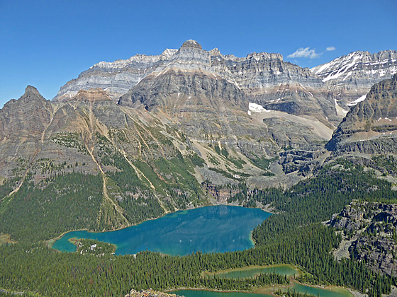
From the Lake O’Hara Day Use facility, head east toward Lake O’Hara on the trail marked for the Lake O’Hara Circuit, Wiwaxy Gap, Lake Oesa and the Yukness Ledges. Reach the lakeshore in 200-ft. Here signboards highlight some of the region’s features. Across the lake Yukness Mountain (9,338-ft.) towers above the lake.
Turn left and follow the lakeshore trail north to a bridge spanning the outlet stream. Here the trail turns right (east) and traverses the lake’s north shore. Views from the lakeshore encompass Mount Schaffler (8,830-ft.), the Schaffler Ridge and Mount Biddle (10,886-ft.) to the south/southeast. Odaray Mountain (10,364-ft.) dominates the view to the west.
After walking 0.2 miles reach a sign marking the start of the Wiwaxy Gap Trail. Turn left (northeast) on the trail. The path now climbs very steeply up the forested slopes of Wiwaxy Peak (8,866-ft.) Tight switchbacks help ease the ascent. Gaps in the trees offer good views of Mount Schaffler, Mount Biddle and the Schaffler Ridge. On a still morning the peaks are reflected in the turquoise waters of Lake O’Hara.
The climb abates briefly at 0.5 miles as the trail turns right and makes a short lateral traverse to avoid an avalanche chute. Soon the climb resumes and the trail passes a large tree offering a good spot to rest. A short distance past the tree the route breaks from the trees, crosses an avalanche chute and then ascends a series of ledges. Beyond the ledges the trail ascends extremely steep scree covered slopes toward Wiwaxy Gap.
As you climb enjoy ever improving views of Glacier Peak (10,768-ft.), Yukness Mountain, Ringrose Peak (10,762-ft.) and Hungabee Mountain (11,457-ft.) to the east/southeast. Mount Biddle and the Schaffler Ridge dominate the view to the south. Soon Lake Oesa is seen cradled in the hanging valley beneath Glacier Peak.
Reach Wiwaxy Gap (8,307-ft.) at 1.1 miles after gaining over 1,600-ft. in 0.9 miles. From the Gap views extend northwest to Cathedral Mountain (10,460-ft.) and Cathedral Crags (10.079-ft.). Mount Huber (11,047-ft.) and Mount Victoria (11,362-ft.) rise to the northwest. Glacier Peak, Ringrose Peak and Hungabee Mountain form the backdrop for Lake Oesa to the east while Mount Biddle and the Schaffler Ridge tower above the O’Hara valley to the south. Rugged Wiwaxy Peak rises above the Gap to the west.
After marveling at the views head southeast on a descending traverse along the Huber Ledges Alpine Route, which offers more stunning views of the O’Hara area. The trail crosses an avalanche chute, drops steeply down a series of ledges and then descends on moderate grades beneath the steep slopes of Mt. Huber on its way to Lake Oesa. Blue and yellow route markers will keep you on track. Ahead are ever improving views of the cirque towering above Lake Oesa.
At 2.2 miles, just before reaching the lake, arrive at the junction with the Abbot Pass Alpine Route that ascends northeast to the Abbot Pass Hut. We turn right (south) toward the Opabin Plateau and Yukness Ledge route. The trail now drops down to a rocky knoll above the west shore of Lake Oesa, passing the junction with the Lake Oesa Trail at 2.3 miles.
Beautiful Lake Oesa lies at the head of a hanging valley, surrounded by a cirque formed by Mount Huber, Mount Victoria, Glacier Peak, Ringrose Peak and Yukness Mountain. The rocky knoll above the western shore is a great place to lounge in the sun and take in the scene.
You can cut the Alpine Circuit short at this point by returning to the Lake O’Hara Day Use area via the Lake Oesa and Lake O’Hara Circuit Trails. The Lake Oesa trail descends the hanging valley, passing three small lakes/tarns along the way, and then drops down steep switchbacks to the east end of Lake O’Hara, losing about 780-ft. in 1.6 miles. Here it joins the Lake O’Hara Circuit trail. Turn right on the circuit and return to the day use and lodge area in 2.2 miles for a 4.5 mile loop. Alternative take the long way around the Circuit by turning left for a 5.3 miles loop.
Lake Oesa to Opabin Lake via the Yukness Ledges Alpine Route
Distance from Trailhead: 0.8 miles (one way)
Ending/Highest Elevation: 7,710-ft.
Elevation Gain: 290-ft.
From the junction with the Lake Oesa Trail, follow the blue and yellow blazes heading south across the rock knoll above the western shore of Lake Oesa. At the southern end of the lake the trail turns away from the lake and drops down to and crosses the lake’s outlet stream near a pretty waterfall.
On the south side of the stream is the beginning of the Yukness Ledge Route. The route ascends northeast across scree covered slopes and then large rock slabs along the lower slopes of Yukness Mountain. Soon the trail enters an area scatter with large boulders.
Pay careful attention to the trail markers through this area. At 2.8 miles the trail turns right and descends a series of steep ledges before swinging left and continuing the descent to a terrific overlook high above the east side of Lake O’Hara at 2.9 miles. Along the way pass a route dropping down to little Lake Victoria and connecting with the Lake Oesa Trail.
Awe inspiring views from the overlook encompass the Odaray massif, the Duchesnay Basin, Cathedral Mountain and Mount Stephens to the northwest. Wiwaxy Peak and Huber Mountain dominated the view to the north while the steep slopes of the Schaffler Ridge rim the valley to the south.
The route now follows an undulating course along a rocky bench, crossing scree slopes, climbing rock ledges and navigating around large boulders. The massive cliffs at the end of Yukness Mountain’s northwest ridge loom overhead. Yukness Lake lies cradled in a rocky bowl below the bench. Jaw-dropping views of the high peaks surrounding Lake O’Hara will slow your progress along this section of the trail.
At 3.2 miles the trail swings to the south and then southeast as it rounds the end of the ridge. After a few more ups and downs the path descends talus slopes and then a large boulder field to reach the trail junction with the East Opabin trail near Hungabee Lake at 4.0 miles.
At the junction you have the choice of continuing on the Alpine Circuit or exiting the circuit and returning to Lake O’Hara Day Use area via the East or West Opabin Circuit Trails. To return via East Opabin, turn right at the junction. The trail descends gently across the Obabin Plateau for 0.3 miles. At the foot of the plateau the descent steepens as the trail enters the trees. Soon the path starts dropping down a series of steep, tight switchbacks that lead to the eastern shore of Lake O’Hara at 4.9 miles. At the lake turn left on Lake O’Hara Circuit Trail which traverses O’Hara’s southern and western lakeshore, reaching the Day Use Facility at 5.7 miles.
Opabin Lake and the All Souls Route to All Souls Prospect
Distance from Trailhead: 7.5 miles (loop)
Ending/Highest Elevation: 8,050-ft.
Elevation Gain: 705-ft.
To continue on the Alpine Circuit, turn left on the East Opabin Circuit trail toward Opabin Lake. Ascend through meadows, climbing a knoll to the Opabin Lake’s northwestern shore at 3.25 miles. The beautiful lake lies in a rugged cirque formed by Yukness Mountain, Ringrose Peak, Hungabee Mountain and the Schaffler Ridge. To the northwest, Mount Schaffler and Wiwaxy Peak frame the views of Mount Stephens and Cathedral Mountain.
After taking a break by the lake, follow the trail as it heads west/northwest around the knoll and then descend through meadows and scree slopes to the western shore of Lake Hungabee. Follow the west Opabin trail through pretty meadows sprinkled with larches. Ahead are lovely views of Mount Schaffler.
The trail now passes a number of junctions with trails connecting to the East Opabin trail and climbing to Opabin Prospect, a scenic overlook. At all intersections continue along the West Opabin trail in the direction of the All Souls Alpine Route. Along the way the trail crosses a steam on a plank bridge to the south of where the stream flows into a tarn. From the bridge, Mount Huber and Wiwaxy Peak dominate the view to the north. The Schaffler Ridge towers overhead to the west.
At 5.25 miles reach a junction where the All Souls Alpine Route turns left (west) while the West Opabin Trail continues straight ahead, descending steeply to Marys Lake. Turn onto the All Souls Alpine Route which immediately crosses a stream and then ascends steeply through boulders and ledges. The trail briefly levels out as it travels through an area of large rock slabs and small streams before resuming the steep ascent.
At 5.5 miles the trail swings to the right (northwest), climbing along the scree slopes of Mount Schaffler. Early in the season expect snow along sections of the trail. The glorious view will help take your mind off the steep, uphill slog.
Reach All Souls Prospect at 6.0 miles. The views from this glorious perch will take your breath away. Laid out in front of you is the route you just walked. Across the valley to the north Winway Peak and Mt. Huber tower above Lake O’Hara. To the northeast are the high peaks ringing the Oesa Plateau. To the west views extend the length of the Opabin Plateau. Mount Owen (10,125-ft.) is seen through the gap formed by McArthur Pass to the southwest while the Odaray massif dominates the view to the northwest. Mount Stephens, Cathedral Peak and the Cathedral Crags fill the skyline to the northwest.
On a clear summer day it will be hard to pull yourself away from this stunning spot. From All Souls Prospect the Alpine Route heads northwest off the high point, descending steeply down scree covered slope, climbing down ledges and detouring around boulders. The knee hammering trail demands your attention, making it difficult to take in the views.
At 6.5 miles reach the junction of the Big Larches Trail. Continue along the trail in the direction of Schaffler Lake. At Schaffler Lake (6.6 miles), turn right and head northeast on the Alpine Meadows trail toward Lake O’Hara and the Elizabeth Park Hut. The trail now resumes the steep descend through forest to the Hut, set in a meadows with a backdrop of the high peaks ringing the Lake O’Hara area. Turn right at the hut and follow the trail back to Lake O’Hara and the Day Use facility at 7.5 miles.
Treat yourself to an ice cream or a cold drink at the Day Use facility. You’ve earned it. End the day by sitting along the lake shore and marveling at the ingenuity of the trail engineers that built the route circling the valley.
Obtaining Reservations for Lake O’Hara
Note: There are four ways to visit Lake O’Hara. All options require advanced reservations that are hard to get.
1.) Obtain a day use permit from the Parks Canada Reservation System Day use reservations typically open in April. Reservations fill very quickly, within the first hour the site is available for booking. (Link - https://reservation.pc.gc.ca/Home.aspx)
2.) Book a campsite thought Yoho National Park Current you must call the park for camping reservations. See the Yoho National Park / Lake O’Hara page for more information. These reservations also fill very quickly. (Link - https://www.pc.gc.ca/en/pn-np/bc/yoho/activ/randonnee-hike/ohara)
3.) Stay at the Elizabeth Parker Hut. See the Alpine Club of Canada website for information on hut reservations. Link: {link - https://www.alpineclubofcanada.ca/web/
4.) Book accommodations at the Lake O’Hara Lodge Accommodations must be booked far in advance. (Link: https://www.lakeohara.com/)
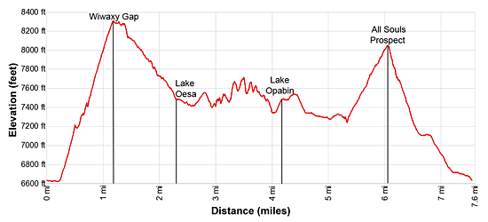
Elevation Profile
Driving Directions
Both day and overnight visitors reach Lake O'Hara by bus. Parks Canada’s Lake O'Hara bus runs mid-June through the end of September or early October. Reservations are required for your in-bound bus journey only. The bus departs from the Lake O’Hara parking lot, 9.0 miles west of Lake Louise, Alberta or 8.3 east of Field, B.C.
From Field, BC: Head east on the Trans-Canada Highway / BC-1 E for 8.3 miles and then turn right (south) onto the signed Lake O’Hara Park Road. Cross the railroad track and then turn right (west) at the next intersection. Follow the road for 0.2 miles to a large parking area and park. Just before the parking area a road branches off to the left (south). This road is blocked. On the right side of the blocked road you will see a large waiting area and information sign boards. The bus to Lake O’Hara leaves from this area.
From Lake Louise, AB: Head west on the Trans-Canada Highway AB-1, which changes to BC-1 W upon entering British Columbia, for 9.0 miles and then turn left (south) onto the signed Lake O’Hara Park Road. Cross the railroad track and then turn right (west) at the next intersection. Follow the road for 0.2 miles to a large parking area and park. Just before the parking area a road branches off to the left (south). This road is blocked. On the right side of the blocked road you will see a large waiting area and information sign boards. The bus to Lake O’Hara leaves from this area.
From Banff, AB: Head northwest on the Trans-Canada Highway AB-1, which changes to BC-1 W upon entering British Columbia, for 40.5 miles and then turn left (south) onto the signed Lake O’Hara Park Road. Cross the railroad track and then turn right (west) at the next intersection. Follow the road for 0.2 miles to a large parking area and park. Just before the parking area a road branches off to the left (south). This road is blocked. On the right side of the blocked road you will see a large waiting area and information sign boards. The bus to Lake O’Hara leaves from this area.
Trail Resources
Trail Intro / Trail Photo Gallery / Trail Map
Basecamp(s) Information:
Yoho / Field
Region Information:
The Canadian Rockies
Other Hiking Regions in:
Alberta / British Columbia