Details: Sabrina Basin 
Distance: 6.0 - 11.8 miles (round trip)
John Muir Wilderness, Inyo National Forest, near Bishop in California's Southeastern Sierra
Hike Facts
- Distance: 6.0 - 11.8 miles (round trip)
- Elevation: 9,050-ft. - 10,988-ft.
- Elevation Gain: 1,350-ft. - 1,938-ft.
- Difficulty: strenuous
- Trail Highlights: See Trail Intro
- Basecamp(s): Bishop / Mammoth Lakes
- Region: California's Southeastern Sierra
This is one of the best hikes in the Bishop area, visiting a series of beautiful lakes nestled in a dramatic basin of 13,000-ft. granite peaks.
Trailhead to Blue Lake
Distance from Trailhead: 6.0 miles (round trip)
Ending/Highest Elevation: 10,400-ft.
Elevation Gain: 1,350-ft.
The trailhead is located below the dam at the north end of Lake Sabrina.
The day use parking area for Lake Sabrina is located at the end of the Highway 168 (see driving directions) on the northwest side of the dam. To reach the Sabrina Basin trailhead walk back down the road for 0.3 miles and look for the trailhead bulletin board on the east side of the road.
From the bulletin board the trail gains 100-ft. as it climbs above the dam to the east side of the lake and then heads south slightly above the eastern shoreline through shrub clad slopes sprinkled with aspen and conifers. Great views extend south to the jagged peaks rising along the Sierra Crest.
Enter the John Muir Wilderness at 0.8 miles. At the one mile mark, about two-thirds of the way along the eastern shore, the trail begins ascending the open slopes above the lake passing the trail to Lake George, which heads left (east) at 1.3 miles. Shortly after the junction the trail dips into a drainage and crosses Lake George’s outlet stream.
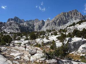
Beyond the crossing the trail enters the trees and climbs a series of switchbacks up the rocky hillside at the southern end of Lake Sabrina, gaining over 975-ft. in 1.3 miles. As you climb the trees thin and views extend northwest to Mount Emerson (13,204-ft.) and the colorful Piute Crags.
Soon the trees give way to scrub covered granite slopes. The open terrain offers ever improving views to the northwest of the high peaks rising above the Sabrina basin along with the Piute Crags.
The ascent continues as the trail turns south at 2.3 miles, traversing along the east side of a draw and then exiting the draw via a series of tight, rocky switchbacks. At 2.7 miles the grade abates.
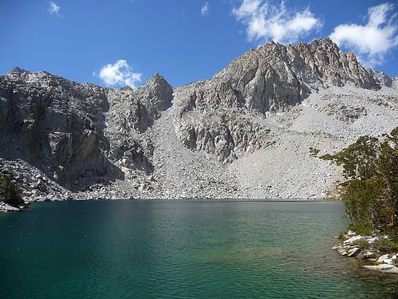
Just beyond a small pond hikers are rewarded with their first views of beautiful Blue Lake (10,400-ft.). The jagged profile of the Thompson Ridge, anchored to the south by Mt. Thompson (13,498-ft.) form the dramatic backdrop for this alpine jewel nestled in a conifer-rimmed granite bowl. Rock-hop across the lake’s outlet stream and follow the trail along the lake’s western shore to a granite outcrop, 3.0 miles from the trailhead, with magnificent views of the lake and surrounding peaks. The best campsites are on located on the granite benches around the west and south sides of the lake.
To Dingleberry Lake
Distance from Trailhead: 9.2 miles (round trip)
Ending/Highest Elevation: 10,500-ft.
Elevation Gain: 1,450-ft.
After soaking in the views return to the trail and continue heading south along Blue Lake’s western shore for a quarter mile to a trail junction. Our trail turns right (northwest) toward Dingleberry Lake. Continuing straight ahead leads to Donkey and Baboon Lakes, a great side trip for hikers with the time and energy.
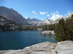
The trail travels along an easy grade, dipping in and out of a rocky draw before curving around the end of a granite ridge and heading southwest into the wooded basin cradling the Emerald Lakes. The first lake, reached at 3.7 miles, is really just a pretty pond set amid a meadow surrounded by trees.
Proceed along the west side of the basin on a gentle grade to the mid-point of the second lake where the trail climbs and then traverses southwest along a low, broad granite ridge. Rock cairns help guide you across the ridge. At 4.3 miles the path turns south and soon reaches a scenic overlook above Dingleberry Lake (10,500-ft.). To the south the jagged peaks of the Sierra Crest, dominated by Mt. Darwin and Mt. Haeckel, fill the skyline.
Follow the trail as it descends from the ridge to Dingleberry’s eastern shore, 4.6 miles from the trailhead. Good campsites can be found at the north and south end of the lake.
To Midnight Lake
Distance from Trailhead: 11.8 miles (round trip)
Ending/Highest Elevation: 10,988-ft.
Elevation Gain: 1,938-ft.
Shorty beyond Dingleberry Lake the trail splits. The horse trail heads left and the hiker’s trail turns right and crosses the Middle Fork of Bishop Creek on rocks. (Early season hikers will need to remove boots and wade across the channel.)
A short distance after the crossing the hiker and horse trails reconnect and the path begins ascending along the east side of a pretty meadow. At the 5.0 mile mark be sure to look east to see a waterfall cascading down Topsy Turvy Lake’s outlet stream.
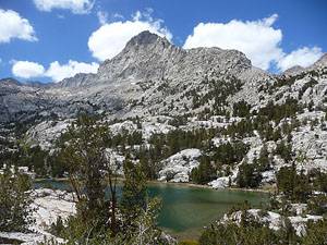
At the end of the meadow switchbacks climb a granite hillside and then ascend along the west side of a drainage to the junction with the Midnight Lake trail, at 5.4 miles. The trail to the left heads to Hungry Packer Lake (11,071-ft.), 7 miles from the trailhead.
To reach Midnight Lake turn right at the junction and follow the trail as it ascends the drainage. Along the way the path crosses the outlet stream for Hell Diver Lakes on logs, passes to the right of a pretty waterfall tumbling down a rocky cliff face, traverses to the west of a small tarn and then rock-hops across the Midnight Lake’s outlet stream. Beyond the tarn the trail climbs to the north shore of Midnight Lake through a landscape of granite slabs and boulders scattered with stunted lodgepole pines, reaching the lake 5.9 miles from the trailhead.
Midnight Lake is set in a deep granite bowl, surrounded on three sides by steep rocky cliffs and jagged peaks. Talus slopes cascade down to the lakes southern shore. To the southwest, Mount Darwin (13,831-ft.) pierces the sky.
After taking in the views retrace your steps to the trailhead.
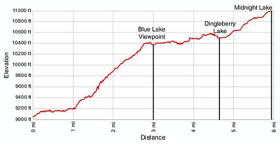
Elevation Profile
Driving Directions
From Bishop: From Highway 395 in downtown Bishop, turn west on Line Street / Highway 168 and drive 18 miles to Lake Sabrina. The day use parking is at the end of the road. From the parking area walk 0.3 miles back down the road to the trailhead, located on the east side of the road.
There are limited parking spaces along the Lake Sabrina Road in the vicinity of the trailhead. Be sure you are pulled well off the road if you use these spots. Overnight parking is located at a dirt lot along the west side of Highway 168, just before the turnoff to North Lake, 0.9 miles down the road from the day use parking area.
From Mammoth Lakes: Drive 3.1 miles southeast on Main Street / CA 203 E and turn right onto the entrance ramp for US 395 S. Follow US 395 south for 39.1 miles to Bishop and turn right (west) on Line Street /Highway 168. Drive on Line Streeet / Highway 168 for 18 miles to Lake Sabrina. The day use parking is at the end of the road. From the parking area walk 0.3 miles back down the road to the trailhead, located on the east side of the road.
There are limited parking spaces along the Lake Sabrina Road in the vicinity of the trailhead. Be sure you are pulled well off the road if you use these spots. Overnight parking is located at a dirt lot along the west side of Highway 168, just before the turnoff to North Lake, 0.9 miles down the road from the day use parking area.
Trail Resources
Trail Intro / Trail Photo Gallery / Trail Map
Basecamp(s) Information:
Bishop / Mammoth Lakes
Region Information:
California's Southeastern Sierra
Other Hiking Regions in:
California