Details: 20 Lakes Basin 
Distance: 4.9 - 9.1 miles (loop)
Hoover Wilderness Area, Inyo National Forest, near Lee Vining in California's Southeastern Sierra
Hike Facts
- Distance: 4.9 - 9.1 miles (loop)
- Elevation: 10,100-ft. - 10,375-ft.
- Elevation Gain: 275-ft.
- Difficulty: easy-moderate
- Trail Highlights: See Trail Intro
- Basecamp(s): Lee Vining / Mammoth Lakes
- Region: California's Southeastern Sierra
The loop around the 20 Lakes Basin travels through breathtaking alpine scenery, visiting nine stunning lakes surrounded by dramatic peaks and ridges. The glorious scenery and relative ease of the trail make this a very popular hike.
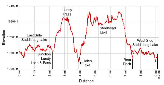
Trailhead to Helen Lake
Distance from Trailhead: 3.8 miles (one way)
Ending/Highest Elevation: 10,375-ft.
Elevation Gain: 275-ft.
The description below provides details on hiking the 20 Lakes Basin in a counter-clockwise direction. Others prefer to walk the trail clock-wise. No matter which way you go you will enjoy a wonderful hike around a scenic basin.
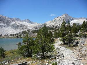
From the hikers parking area walk up the road and through the day use parking lot (behind the resort) to the trailhead at the southern end of the lake. Follow the trail as it contours around the bottom of Saddlebag Lake (10,066-ft.) and then heads northwest along the lake’s eastern shore on an old road. The Shepherd Crest and Excelsior Mountain dominate the skyline to the northwest. On the eastern side of the lake views open to North Peak (12,242-ft.) and to the southwest, White Mountain (12,057-ft.) and False White Mountain (12,002-ft.).
Just beyond the head of the lake reach a trail junction at 2.25 miles. Turn right toward Lundy Lake and Lundy Pass. The left fork leads to boat dock and Steelhead Lake. The trail now climbs on easy to moderate grades through rocky meadows sprinkled with pines. Along the way pass the Hoover Wilderness boundary and enjoy fine views of North Peak and Mount Conness (12,590-ft.) rising above the low hills to the west of the trail.
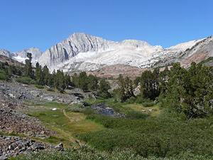
The grade levels briefly as the trail crosses a small draw to the west of pretty little Hummingbird Lake (10,244-ft.) nestled in a shallow bowl beneath the western flanks of the Tioga Crest. Beyond the lake the path resumes it climb, reaching Lundy Pass (10,345-ft.) at 3.1 miles.
As you approach the pass views open to Odell Lake (10,267-ft.), tucked in a rocky bowl beneath the right (east) side of the trail and surrounded by steep multi-hued cliffs. Follow the trail as is descends to the northwest end of the lake and then drops steeply down a rocky gorge decorated with wildflowers. Initially the trail stays to the left (west) of Odell’s outlet steam but midway down the gorge crosses to the right (east). Ahead, the craggy cliffs of Lundy Canyon form a colorful backdrop to Helen Lake, lying in a deep bowl at the bottom of the gorge.
Upon reaching Helen Lake (10,107-ft.) the trail turns right (northeast) and parallels the lakeshore reaching the outlet on the east end of the lake at 3.8 miles. Along the way the trail enjoys wonderful views of the Shepherd Crest, rising to the north. To the west Mount Conness and North Peak form a glorious backdrop for waterfalls cascading down rocky meadows and into the lake.
To Steelhead Lake
Distance from Trailhead: 5.2 miles (one way)
Ending/Highest Elevation: 10,340-ft.
Elevation Gain: 240-ft.
A signed trail junction at the outlet streams offers the choice of turning right (east) toward Lundy Canyon or crossing the outlet stream and heading northwest toward Steelhead Lake. If time permits a brief detour in the direction of Lundy Canyon is recommended. An overlook atop a large rock outcropping to the south of the trail, about 0.1 miles to the right (east), provides nice views into Lundy Canyon. To the west North Peak frames the pretty meadows along Lake Helen’s outlet stream.
After taking in the views return to the trail junction, cross the outlet stream and follow the trail west through scree covered slopes along the north side of Helen Lake. Beyond the lake a short, steep ascent traverses the meadows to the north of the inlet stream and then climbs the headwall to the basin cradling Shamrock and Steelhead Lakes. The upper end of this trail is a marked by cairns and is a tad sketchy.
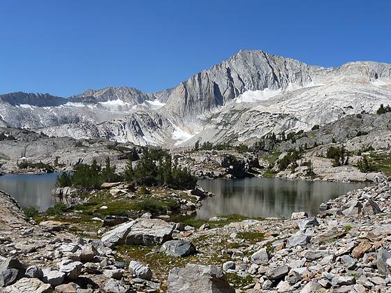
Reach the north shore of gorgeous Shamrock Lake (10,250-ft.) at 4.6 miles. The setting looks like a scene from a picture postcard. Stunted whitebark pines grow amid the granite ledges and rocky meadows ringing the shoreline of this glistening alpine jewel. Stunning North Peak and the ridges of Mount Conness dominate the skyline to the southwest. Sheer, multi-hued crags tower above the lake to the north.
Head west, traversing talus slopes along the lake’s north shore. Past Shamrock Lake the path climbs through pretty meadows and then ascends to the top of a rock knoll to the north of a small, unnamed lake. Be sure to turn around for great views of the Tioga Crest to the east.
At the top of the knoll the trail splits. The official trail heads south across the knoll and then drops to a crossing on the outlet stream of Steelhead Lake. A well defined used trail continues west, dropping through a rocky meadow to an old mining road running along the east side of Steelhead Lake (10,270-ft.), 5.2 miles from the trailhead. Upon reaching the dirt road the trail turns left (south). (Following the road to the right leads to the site of the abandoned Hess Mine.) In a short distance the road crosses the outlet stream and turns left (east), meeting the official trail coming down off the rocky knoll at a signed trail junction.
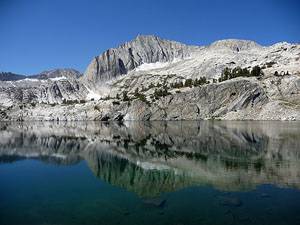
Beyond the junction follow the road as it curves south and then west, climbing over a rocky ridge to Steelhead Lake’s eastern shore. From this vantage point enjoy breathtaking views of North Peak, reflected beautifully in the lake’s azure blue waters. At the north end of the long narrow lake, the granite summit of Shepherd Crest East (12,020-ft.) contrasts nicely with the orange, brown and gray slopes of the peak’s southeast ridge.
Completing the Loop
Distance from Trailhead: 9.1 miles (loop)
Ending/Highest Elevation: 10,375-ft.
Elevation Gain: 275-ft.
Head south along the lake’s eastern shore. At the end of the lake, 5.8 miles from the trailhead, a use trail drops down to and crosses the inlet stream, contours around the south end of the lake and then climbs west to the Cascade Lakes basin. If time and energy permit this is a nice side trip. The ice-polished knolls and small meadows of this basin harbor nice campsites and great views of North Peak.
Past the end of the lake the trail continues south on a gentle ascending traverse past a few small tarns nestled in the draw to the west of the road. Just before reaching Wasco Lake (10,325-ft.) the road turns left (east) and climbs a moderate grade for a short distance before turning south again and descending to the north shore of Greenstone Lake (10,127-ft.), at 7.1 miles. The lake shore enjoys fine views of the sea of granite peaks and ridges extending from North Peak and Mount Conness.
From the lake shore the trail heads southeast for 0.2 miles to a trail junction. The trail straight ahead leads to the boat dock. To complete the loop take the trail to the right (southwest) that crosses Greenstone’s outlet stream and then contours along the west side of Saddlebag Lake. Views extend north to the Shepherd Crest and Excelsior Mountain to the north and the Tioga Crest to the east.
At the foot of the lake the trail descends to a road crossing the bridge over Saddlebag Lake’s outlet stream just below the dam and then climbs to the Saddlebag Lake Road. Turn left (northeast) and follow the road back to the hiker’s parking area. The total distance for the loop hike is 9.1 miles, including side trips. Without side trips the loop hike is 8.4 miles.
If you prefer to take the boat back, continue straight ahead at the trail junction and descend to the boat dock at the north end of Saddlebag Lake, 7.4 miles from the trailhead including side trips (6.7 miles without side trips).
Taking the boat in both directions will reduce the loop hike to 4.9 miles. Parties who prefer a shorter hike might want to simply hike from the boat dock to upper end of Steelhead Lake, a distance of 3.8 miles round trip.
Whether you reach the lakes basin on foot or by boat or walk in a counter-clockwise or clockwise direction, you will have a great trip. Keep in mind that while the elevation gains and losses on the trail do not exceed a few hundred feet, you will be hiking above 10,000-ft. the entire way. Those that are not acclimated will need to take it slow.
The gorgeous scenery and relative ease of the hike make this trail popular with hikers, fishermen and backpackers of all ages, so solitude will be in short supply. But do not let the popularity of the hike deter you. Pick a day full of promise and get an early start so you can spend as much time as possible in this special place.
Elevation Profile
Driving Directions
From Lee Vining: Drive south on Highway 395 for 0.7 miles and turn right (west) onto Highway 120, the Tioga Pass Road, heading toward Yosemite. Follow the road for 9.9 miles and turn right (north) onto the Saddlebag Lake Road. The turnoff is located shortly after Ellery Lake. Drive to the end of the paved/dirt road, 2.5 miles from the highway. (Just after the turnoff stay right, do not turn into the campground.) The hiker’s parking lot is to the right of Saddlebag Lake’s dam. Additional parking is available in a large day use parking lot behind the resort. In the summer tickets for the water taxi that runs to the head of the lake can be purchased at Saddlebag Lake Resort.
From Mammoth Lakes: Drive north on Highway 395 for 25 miles and turn left (west) onto Highway 120, the Tioga Pass Road, heading toward Yosemite. Follow the road for 9.9 miles and turn right (north) onto the Saddlebag Lake Road. The turnoff is located shortly after Ellery Lake. Drive to the end of the paved/dirt road, 2.5 miles from the highway. (Just after the turnoff stay right, do not turn into the campground.) The hiker’s parking lot is to the right of Saddlebag Lake’s dam. Additional parking is available in a large day use parking lot behind the resort. In the summer tickets for the water taxi that runs to the head of the lake can be purchased at Saddlebag Lake Resort.
From Tuolumne Meadows in Yosemite National Park: Drive east on Highway 120, the Tioga Pass Road, for 10.3 miles and turn left (north) onto the Saddlebag Lake Road. The turnoff is located 0.8 miles past Tioga Lake. Drive to the end of the paved/dirt road, 2.5 miles from the highway. (Just after the turnoff stay right, do not turn into the campground.) The hiker’s parking lot is to the right of Saddlebag Lake’s dam. Additional parking is available in a large day use parking lot behind the resort. In the summer tickets for the water taxi that runs to the head of the lake can be purchased at Saddlebag Lake Resort.
Trail Resources
Trail Intro / Trail Photo Gallery / Trail Map
Basecamp(s) Information:
Lee Vining / Mammoth Lakes
Region Information:
California's Southeastern Sierra
Other Hiking Regions in:
California