Details: Ediza Lake 
Distance: 7.8 - 13.4 miles (round trip)
Ansel Adams Wilderness Area, Inyo National Forest, near Mammoth Lakes in California's Southeastern Sierra
Hike Facts
- Distance: 7.8 - 13.4 miles (round trip)
- Elevation: 8,322-ft. - 9,774-ft.
- Elevation Gain: 415-ft. - 1,452-ft.
- Difficulty: strenuous
- Trail Highlights: See Trail Intro
- Basecamp(s): Mammoth Lakes / Lee Vining
- Region: California's Southeastern Sierra
The jagged spires of the Minarets, along with Mount Ritter and Banner Peak, form the dramatic backdrop for Ediza Lake, one of the most stunning lakes in the Ritter Range. This hike visits this alpine jewel, passing beautiful Shadow Lake and a series of pretty waterfalls on Shadow Creek along the way.
Trailhead to Shadow Lake
Distance from Trailhead: 7.8 miles (round trip)
Ending/Highest Elevation: 8,737-ft.
Elevation Gain: 697-ft.
Hikers taking the Devil’s Postpile Shuttle Bus to the trailhead (see driving directions below) should get off the bus at stop #1, Agnew Meadows. Walk up the dirt road to the second trailhead parking area. The trail starts at the southwest end of the parking lot.
Follow the trail as it skirts along the south side of a meadow and enters the trees, descending on a gentle grade. Pass a spur trail to the campground, the boundary marker for the Ansel Adams Wilderness and reach a signed trail junction at 1.7 miles. Continue straight ahead in the direction of Shadow Lake. The trail to the left heads toward Red’s Meadow and the Devil’s Postpile.
Beyond the junction the trail descends on moderate grades across open slopes, losing 230-ft., to the junction with the River Trail (8,040-ft.) at 1.8 miles. Turn right on the River Trail toward Shadow Lake. (Heading left on the River Trail leads to Reds Meadows.) Follow the wide, dusty trail as it ascends the Middle Fork of the San Joaquin River valley on gentle grades through forest and small meadows.
At 2.3 miles pass to the left (east) of the forested shores of Olaine Lake. At 2.7 miles the trail splits. Turn left (west) on the Shadow Lake Trail. (The trail to the right leads to 1,000 Island Lake.) Shortly after the junction cross the Middle Fork on a good bridge, 2.9 miles from the trailhead.
The trail now climbs moderately steep switchbacks up an exposed rocky hillside clad in sage brush and junipers, paralleling Shadow Creek. Near the top of the climb the trail ascends a series of granite steps beside a scenic waterfall cascading down rocky clefts carved by the creek.
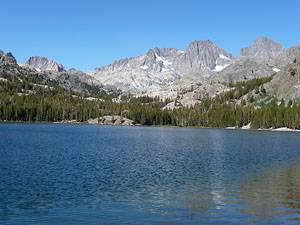
After gaining close to 700-ft. in just under a mile the grade abates as the trail passes through a narrow gap between the rock face and the creek and emerges at the northeast shore of Shadow Lake (8,737-ft.), 3.9 miles from the trailhead. Mt. Ritter (13,143-ft.) and Banner Peak (12,936) dominate the skyline to the west.
To Ediza Lake
Distance from Trailhead: 13.4 miles (round trip)
Ending/Highest Elevation: 9,265-ft.
Elevation Gain: 1,225-ft.
The trail traverses along the northern shore of Shadow Lake for half a mile. Just beyond the end of the lake the trail connects with and joins the John Muir Trail (JMT) heading northbound. The southbound JMT turns left (south) at this point and crosses the lake’s inlet stream on a bridge. Our trail, the northbound JMT, continues straight ahead.
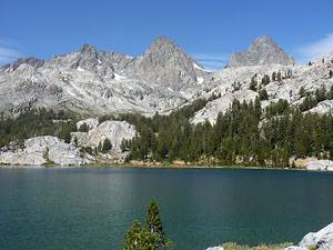
For the next 0.6 miles the trail follows the JMT ascending on gentle to moderate grades along the north side of Shadow Creek, passing waterfalls and pretty cascades along the way. At 5.1 miles the trail splits. The JMT turns right (northwest) toward Garnet Lake. Our trail to Ediza Lake continues ascending the scenic Shadow Creek Valley, wandering through meadows and forest beside the cascading stream. Openings in the forest provide nice views of Volcanic Ridge, rising to the south.
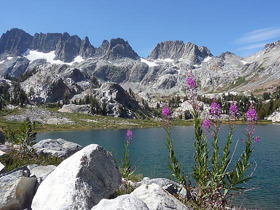
Cross Shadow Creek on a log bridge at 6.4 miles. Past the bridge the trail climbs switchbacks and then traverses around the north end of a granite knoll to Ediza Lake (9265-ft), 6.7 miles from the trailhead. Views from the eastern shore of this alpine jewel are breathtaking. The lake is cradled beneath the rugged ramparts of the Ritter Range. Banner Peak and Mount Ritter tower above the northwest end of the lake while the jagged spires of the Minarets frame the lake to the southwest.
Campsites are located on the western and northern side of the lake. No camping is allowed along the eastern shore.
Optional Trip to Iceberg and Cecile Lakes
Distance from Trailhead: 16.6 miles (round trip)
Ending/Highest Elevation: 10,239-ft.
Elevation Gain: 2,200-ft.
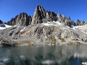
It is possible to visit two small lakes, Iceberg (9,774-ft.) and Cecile (10,239-ft.), located to the south of Ediza. The use trail to Iceberg Lake follows the boot beaten path along Ediza’s eastern shore to the south end of the lake where the route climbs a moderately steep granite bench, staying to the east of pretty creek cascading down the hillside. The creek is Iceberg Lake’s outlet stream. After climbing for 0.6 miles and gaining about 390-ft. the grade abates as the route traverses a lovely meadow to Iceberg Lake at 7.7 miles. The scenic lake is cradled in a deep granite bowl directly beneath the Minarets.
The route to Cecile Lake is more difficult, climbing the steep rocky headwall at the south end of Iceberg Lake. When climbing aim for the point slightly to the east of Cecile’s outlet stream. Lingering snow and ice can make the ascent quite challenging. Cecile’s setting is equally dramatic with the spires of the Minarets forming a perfect backdrop for this azure jewel. Total distance to Cecile Lake from Ediza Lake is 1.5 mile (8.3 miles from the trailhead) with a 974-ft. elevation gain (2,200-ft. elevation gain from the trailhead).
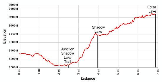
Elevation Profile
Driving Directions
From Mammoth Lakes: Drive 3.7 miles through town on Highway 203 and turn right on Minaret Road. Follow Minaret Road for 4.2 miles to the Mammoth Mountain Adventure Center (Main Lodge) at the Mammoth Ski Resort. During the summer park in the day use or overnight parking lot and board the mandatory shuttle bus to the trailhead. Get off at Shuttle Stop #1, Agnew Meadows.
After hours or in the fall you can drive to the trailhead. If driving, continue on Minaret Road for 1.2 miles to the pay station. Pay the appropriate fee and then drive down Postpile Road for 2.7 miles. Turn right on the Agnew Meadows Road (located at the hairpin curve). Follow the dirt road for 0.4 miles to the second trailhead parking lot (on your left) and park. The trailhead is at the southwest end of the parking lot.
See the Devil’s Postpile Shuttle Bus page for current schedules and fee information.
From Lee Vining: Drive south on Highway 395 for 25.3 miles to the Mammoth Lakes / Highway 203 exit. Then follow the directions from Mammoth Lakes to the trailhead.
From Bishop: Drive north on Highway 395 for 38.8 miles to the Mammoth Lakes / Highway 203 exit. Then follow the directions from Mammoth Lakes to the trailhead.
Trail Resources
Trail Intro / Trail Photo Gallery / Trail Map
Basecamp(s) Information:
Mammoth Lakes / Lee Vining
Region Information:
California's Southeastern Sierra
Other Hiking Regions in:
California