Details: Lakes Trail - Heather, Emerald and Pear Lakes 
Distance: 8.2 - 12.8 miles (round trip)
Sequoia-Kings Canyon National Park, near Lodgepole in California's Southwestern Sierra
Hike Facts
- Distance: 8.2 - 12.8 miles (round trip)
- Elevation: 7,280-ft. - 9,550-ft.
- Elevation Gain: 2,000-ft. - 2,490-ft.
- Difficulty: moderate-strenuous
- Trail Highlights: See Trail Intro
- Basecamp(s): Lodgepole
- Region: California's Southwestern Sierra
The Lakes Trail, one of the most popular hikes in Sequoia National Park, climbs through dense forest to a landscape of polished granite dotted with four beautiful lakes and set amid a backdrop of rugged ridges anchored by Alta Peak (11,204-ft.).
Trailhead to Heather Lake
Distance from Trailhead: 8.2 miles (round trip)
Ending/Highest Elevation: 9,280-ft.
Elevation Gain: 2,000-ft.
From the trailhead, located on the north side of the Wolverton parking area, the path heads north, climbing a few stairs and then ascends on moderate grades to a trail junction near the top of a ridge at 0.1 miles. At the junction the trail to the left descends to Lodgepole. Turn right (east) and follow the Lakes Trail as it ascends on easy to moderate grade through trees along or near the top of the ridge for one mile. Wolverton Creek, hidden by the trees, flows below the trail to the south.
At 1.1 miles the trail curves to the southeast, following the course of Wolverton Creek. Shortly after crossing a small stream the trail turns left (east) and arrives at the Alta Peak / Mehrten Meadow trail junction, which branches to the right (southeast), 1.8 miles from the trailhead. Turn left (north) and continue along the trail to Heather and Pear Lakes.
The trail now climbs steeply up the forested hillside, re-crossing the stream and arriving at a trail junction at 2.1 miles. At this point you have a choice of turning right and following the Hump Trail to Heather Lake or continuing straight ahead on the Watchtower Trail to Heather Lake. The Hump trail requires more elevation gain (about 200-ft), is shadier and doesn’t have the exposure of the scenic Watchtower Trail, which travels for a half mile along a ledge blasted from a sheer cliff high above the Marble Fork of the Kaweah River canyon.
I recommend continuing straight on the Watchtower trail. The path ascends on moderate grades through trees, along the way crossing a draw lined with ferns and pretty wildflowers. Soon the trail turns northeast and climbs high above the Marble Fork canyon.
About a mile past the junction the path ascends two switchbacks to an overlook (3.3 miles) beside the Watchtower, a 1,800-ft. sheer granite spire jutting from cliff along the south side of the valley. A route, really more of a scramble, leaves from the end of the first switchback and climbs a steep friction pitch to the top of the pinnacle.
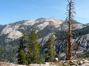
The overlook enjoys dizzying views down into valley. To the east is the granite expanse of the Tablelands and Tokopah Falls, a series of cascades tumbling down steep granite slopes to the canyon floor. Mt. Silliman (11,188-ft.) rises above the ridge to the north.
Beyond the Watchtower the trail climbs high above the south side of the canyon on a path chiseled into the steep granite cliff face. Along the way enjoy fabulous views of Mt. Silliman, the sheer cliffs along the canyon’s northern wall and the upper end of the Marble Fork Canyon. Looking down you will see a trail snaking along the rocky canyon floor to the base of Tokopah Falls.
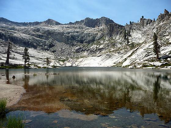
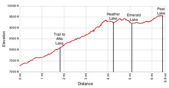
At 3.8 miles the grade abates and the trail travels along easy grades to the junction where the Hump trail rejoins the main trail. Past the junction the path gently descends to Heather Lake (9,280-ft.), 4.1 miles from the trailhead. The rocky shore of this pleasant little lake is lined with grasses, scrub willows and scattered red firs. A steep, rugged slope rises above the south and east shores. The granite ledge to the north of the lake enjoy great views of Mt. Silliman and offers a nice place to rest before continuing the hike to Aster and Emerald Lakes. (Note that camping is not allowed at the lake.)
Heather Lake to Emerald Lake
Distance from Trailhead: 10.6 miles (round trip)
Ending/Highest Elevation: 9,230-ft.
Elevation Gain: 2,170-ft.
To continue to Emerald and Aster Lakes follow the trail as is climbs above the hillside on the east side of the Heather Lake and then curves around the end of a ridge. The open terrain offers great views across the valley and up the Marble Fork Canyon.
The trail turns northeast as it rounds the ridge and begins a moderate decent to Emerald Lake. Along the way views open to Alta Peak (11,204-ft.) and the jagged ridges surrounding the lake basin. Below the trail, to the east, Aster Lake sits serenely in a granite bowl. A spur trail, leaving the main trail at the 5 mile mark, travels north to the lake.
Beyond the junction the trail climbs over granite slabs and arrives at the junction with the spur trail to Emerald Lake, near a solar toilet, at 5.1 miles. Follow the spur trail as it wanders through boulders and red firs to the northern shore of Emerald Lake (9,230-ft.), 5.3 miles from the trailhead.
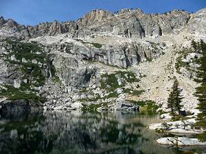
Pretty Emerald Lake is tucked beneath steep, rugged granite ridges extending from Alta Peak, located to the southeast. Willows, shrubs and a few scattered trees grow amid the granite slabs lining the shore. Eight campsites are located among the rocks and trees to the north of the lake. See the campsite bulletin board at the lake for the exact locations.
Emerald Lake to Pear Lake
Distance from Trailhead: 12.8 miles (round trip)
Ending/Highest Elevation: 9,550-ft.
Elevation Gain: 2,490-ft.
To continue to Peak Lake return to the main trail and turn right (north). Follow the rocky trail as it ascends on easy grades around the granite ridge running along the east side of the Emerald Lake Basin. This section of the trail enjoys nice views of lovely little Aster Lake and Mt Silliman.
Toward the end of the ridge the trail curves east, passing a spur trail, on the left, heading to the Pear Lake ranger station at 5.9 miles. Beyond the junction the trail climbs a moderately steep hillside through rocky meadows with scattered trees. Views extend west to the Watchtower and to the peaks and ridges lining the northern side of the Marble Fork Valley. As you ascend the trees thin and the trail turn southeast into the Pear Lake Basin, traveling through a landscape of broken granite slabs.
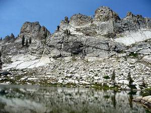
At 6.3 miles the grade abates and then follows a gentle decent to the northern shore of Pear Lake (9,550-ft.), 6.4 miles from the trailhead. This beautiful lake is ringed by glacial polished granite slabs and cliffs. The rugged profile of Alta Peak (11,204-ft.) and its adjoining ridges frame the cliff face rising above the lake’s south shore. Ten designated campsites are spread among the trees on either side of the outlet stream at the north end of the lake.
After soaking in the views retrace your steps, enjoy the wonderful views in reverse.
Note that high demand for a limited number of camping spots makes it difficult to obtain a backpacking permit for the Lakes Basin. The permits are currently issues on a first come, first serve basis. See the Wilderness Permits page on the Sequoia National Park website for more information. (http://www.nps.gov/seki/planyourvisit/wilderness_permits.htm)
Elevation Profile
Driving Directions
From Three Rivers / Highway 198: Follow Highway 198 / the Generals Highway for 25 miles, through entrance station for Sequoia-Kings Canyon National Park to Giant Forest, passing the Giant Forest Museum along the way. About 0.5 miles beyond the handicapped parking area for the General Sherman Tree turn right (east) onto the Wolverton Road. The road is signed for the main parking area for the General Sherman Tree. Travel along the Wolverton Road to its end, 1.4 miles from Highway 198/Generals Highway. Turn left into the large parking area and park near the trailhead on the north side of the lot.
From Fresno / Highway 180: Follow Highway 180 east for 60.8 mile, past the entrance station for Sequoia-Kings Canyon National park, to the junction where Highway 180 splits off left (north) towards Grant Grove and Highway 198 heads right (southeast) towards the Giant Forest in Sequoia. Turn right onto Highway 198/Generals Highway towards Sequoia National Park and follow the road for 26.2 miles, passing the Wuksachi Lodge and Lodgepole Village along the way. Turn left (east) onto the Wolverton Road. (The Wolverton road is 1.6 miles south of Lodgepole Village on Highway 198/Generals Highway and is signed for the main parking area for the General Sherman Tree.) Travel along the Wolverton Road to its end, 1.4 miles from Highway 198/Generals Highway. Turn left into the large parking area and park near the trailhead on the north side of the lot.
Trail Resources
Trail Intro / Trail Photo Gallery / Trail Map
Basecamp(s) Information:
Lodgepole
Region Information:
California's Southwestern Sierra
Other Hiking Regions in:
California