Details: Cathedral Lake 
Distance: 5.6 miles (round trip)
Maroon Bells-Snowmass Wilderness, White River National Forest, near Aspen in Central Colorado
Hike Facts
- Distance: 5.6 miles (round trip)
- Elevation: 9,880-ft. - 11,866-ft.
- Elevation Gain: 1,986-ft.
- Difficulty: strenuous
- Trail Highlights: See Trail Intro
- Basecamp(s): Aspen
- Region: Central Colorado
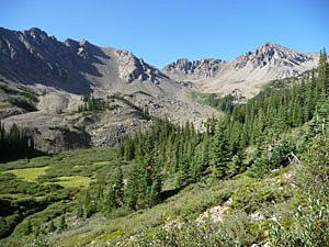
This popular hike ascends steeply up Pine Creek canyon, traveling through forests and meadows to Cathedral Lake, a gorgeous alpine gem nestled in a dramatic cirque beneath rugged granite peaks.
Trailhead to Cathedral Lake
The trail to Cathedral Lake and Electric Pass wastes no time gaining altitude. From the parking area (see driving directions) the trail immediately starts climbing through beautiful groves of mature aspen. Soon the trail curves to the west and enters the Pine Creek Valley at an overlook with scenic views of the upper Castle Creek valley.
Once in the Pine Creek drainage the ascent steepens as the trail climbs above the north side of Pine Creek through aspen groves that give way to spruce/fir forest. Pine Creek rushes down the ever deepening gorge beside the trail. At 0.7 miles the trail passes a pretty waterfall along the creek.
Past the falls the trail continues its ascent on steep grades. Meadows and openings in the trees offer fine views of the rugged ridge rimming the south side of the valley. Be sure to turn around for nice views across the Castle Creek Valley.
The grade abates at 1.5 miles as the trail crosses a boulder field created by rock slides cascading from the steep slopes to the north of the trail. The boulder field provides the first views of the peaks at the head of the valley.
Beyond the boulder field the trail traverses a stand of trees and then follows gentle grades as it curves to the right (northwest) above a boggy, willow-choked meadow at 1.6 miles. The open meadow offers fine views of Malamute Peak (13,348-ft.) and several unnamed peaks rising above the head of the valley.
Past the meadow the trail turns left (west) and climbs through scrub brush and trees, crossing a small rockslide beneath the south facing slopes of Leahy Peak (13,322-ft.) at 1.7 miles. The grade steepens at 2.0 miles as the path crosses a large talus field and then ascends steep switchbacks up the basin's headwall.
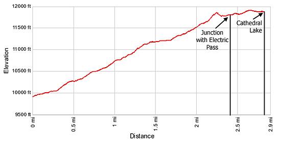
Crest the top of the headwall at 2.2 miles. The grade now moderates as the trail heads southwest and soon reaches a junction at 2.3 miles. Here the trail to Electric Pass turns right (west). We continue straight ahead toward Cathedral Lake.
Beyond the junction the trail ascends through fields of willows with scattered stands of trees as it climbs a bench to the lake basin. Along the way the path goes by a second junction with a side trail that branches right and connects with the trail to Electric Pass. Shortly after the second junction the trail crosses Cathedral Lake’s outlet stream with the aid of a few logs and well placed rocks.
The final ascent to the lake features even improving views of the rocky crags and spires rising above the head of the basin. To the northwest views open to Peak 13635.
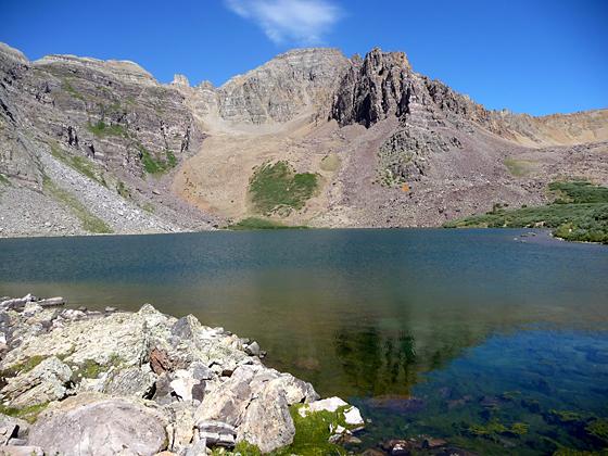
After cresting a small hill stunning Cathedral Lake springs into view. The trail now descends gently to the lake at 2.8 miles. Cathedral Lake is an alpine jewel surrounded by jagged granite peaks and crags. Cathedral Peak towers above the lake to the west while Malamute Peak anchors the ridge to the south. Look to the northwest to see the trail to Electric Pass climbing the stark talus ridge to the left of Leahy Peak.
Hikers with the time and energy will want to extend the hike by climbing the challenging and steep trail to Electric Pass, a spectacular viewpoint on a high ridge running between Cathedral Peak and Peak 13635. I recommend hiking to the pass first and then visiting the lake. The aptly names Electric Pass is a lightening magnet. Hikers should be off the pass and below the saddle leading to the pass before noon to avoid electric storms that frequently hit the area in the early afternoon.
Elevation Profile
Buy the BookThis opinionated guide includes all the hikes in the Aspen, Buena Vista, Crested Butte, Marble and Leadville sections of the website plus info on local services and nearby attractions. | |
Driving Directions
Driving Directions from Aspen:
Drive 0.5 miles west of Aspen on CO 82 to the roundabout. Go around the roundabout and turn right at the Castle Creek Road. (The Castle Creek Road is the third exit on the roundabout when heading west on CO 82.) Drive 12.2 miles on the Castle Creek Road and turn right onto a gravel road signed for the Cathedral Lake trail. The turn is shortly after Ashcroft, a restored ghost town open to the public. Continue 0.5 miles up the rough gravel/dirt road. Over the years the road has deteriorated. Passenger vehicles with good clearance, if driven carefully, can make it to the trailhead parking area.
This is a popular trailhead and the lot fills early during the summer. If the lot is filled, additional parking can be found along the access road.
Trail Resources
Trail Intro / Trail Photo Gallery / Trail Map
Basecamp(s) Information:
Aspen
Region Information:
Central Colorado
Other Hiking Regions in:
Colorado