Details: Josephine Lake 
Distance: 7.7 - 8.0 miles (round trip)
Holy Cross Wilderness, White River National Forest, near Aspen in Central Colorado
Hike Facts
- Distance: 7.7 - 8.0 miles (round trip)
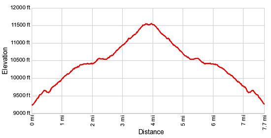
- Elevation: 9,240-ft. - 11,550-ft.
- Elevation Gain: 2,310-ft.
- Difficulty: moderate-strenuous
- Trail Highlights: See Trail Intro
- Basecamp(s): Aspen
- Region: Central Colorado
The lightly used trail to Josephine Lake wanders through forest, passes two large parks and then travels along a ridge with fine, albeit distant, views of the Elk Mountain Range and nearby 12,000-ft. peaks.
Trailhead to Josephine Lake
The trail to Josephine Lake starts on the left (northwest) side of Road 501 at the Henderson Park Trailhead. (See driving directions.) The rocky trail initially heads northwest, climbing steeply up grassy slopes through scattered conifers and aspens. Pass the sign for the Holy Cross Wilderness in 0.1 miles. Soon the trail curves to the right (northeast) and continues its steep ascent. Here views open to the wooded hills to the east.
After hiking 0.4 miles the grade abates. The respite is brief and soon the climb resumes, now on moderately steep grades through aspen groves growing amid ferns, corn lilies, wildflowers and tall grasses. A rock outcropping at 0.8 miles offers nice views to the east. A few switchbacks facilitate the ascent.
At 1.5 miles the trail plunges into a spruce/pine forest. Soon the grade abates and the trail travels on easy grades along the right (east) side of a small creek.
Reach a trail junction at 1.7 miles. Here the Henderson Park trail turns right (east) toward Carter Lake. We continue straight ahead on the Tellurium Lake Trail. Beyond the junction cross to west side of the creek and continue along the trail a short distance to the southwest corner of pretty Henderson Park, a large marshy meadow. Peak 12191 towers above the park to the northeast. Smaller peaks and ridges rise to the east. Our trail will eventually climbs along the ridge extending west from Peak 12191.
The trail now heads north through trees, skirting the west side of Henderson Park. In the early morning you may be lucky enough to spot deer or elk grazing in the meadows.
Past the northwest corner of Henderson Park at 2.0 miles the trail climbs steeply for a short distance and then drops down to the southwest corner of Coffeepot Park, a smaller meadow at 2.3 miles. Here we get another view of Peak 12191 to the northeast. The summits of several 12,000-ft. mountains peek above the trees to the north.
Follow the trail as it travels along the western edge of Coffeepot Park to a trail junction just beyond the northwest end of the meadow. To the left (west) is the Last Chance trail. We bear slightly right on the trail toward Josephine Lake.
The trail now climbs on moderate to moderately steep grades through forest and soon curves to the right (northeast). At 3.2 miles the trail turns right (east) near the crest of the ridge. Beyond this point the trail ascends through scattered trees along the south side of the ridge, just below the crest. As you gain elevation the trees thin and terrific, albeit distant, views open to the Elk Mountains to the south.
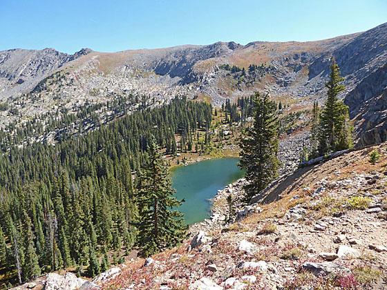
At 3.5 miles the trail briefly travels along the top of the ridge with great views of the jagged 12,000-ft peaks rising to the north. Attain the top of the ridge again at 3.9 miles. Josephine Lake is now visible below the north side of the ridge, tucked in a rocky basin beneath the rugged west face of Peak 12191. A very steep trail drops down from ridge to the little cobalt blue lake at 4.0 miles. Use care when descending the steep trail to the lake.
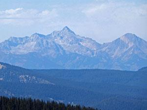
While the lake is nice, my preference is to have lunch atop the ridge and enjoy the great, albeit distant, panoramic views of the Elk Range to the south stretching from Mount Sopris to the Collegiate Peaks. On a clear day you should be able to pick out Capitol Peak, Snowmass Mountain, the Maroon Bells and Pyramid Peak. Near at hand a rugged ridge of 12,000-ft peaks fills the skyline to the north/northwest of the lake basin.
If time and energy permit, continue up the ridge to the top of Peak 12191. There is no trail but the route is obvious. From the summit enjoy views of Savage Peak (13,191-ft.) rising to the east above the Carter Creek basin. Below you are Carter Lake and Savage Lake. In the distance are the peaks and lakes in the Hunter Fryingpan and Holy Cross Wilderness areas along with the Elk Mountain Range to the south. This side trip will gain over 640-ft in elevation and add 1.4 miles round to the hike.
When you are done enjoying the views, retrace your steps to the trailhead.
Elevation Profile
Buy the BookThis opinionated guide includes all the hikes in the Aspen, Buena Vista, Crested Butte, Marble and Leadville sections of the website plus info on local services and nearby attractions. | |
Driving Directions
Driving Directions from Aspen: From the corner of Mill Street and Main Street in Aspen, drive west on West Main Street/CO 82 W for 17.5 miles and turn right on 2 Rivers Road in Basalt. Travel on 2 Rivers Road for 0.8 miles and turn right onto Midland Ave which turns into the Fryingpan Road. Follow the scenic Fryingpan Road as it travels along sections of the beautiful Fryingpan River and high above Ruedi Reservoir for 27 miles to an intersection with Road #501 (County Road 4B). There will be a sign for the Elk Wallow Campground at the intersection. Turn left on Road #501. (This turn is right before the Fryingpan Road crosses the Fryingpan River.)
Drive 4.5 miles on Road 501 to a “Y” intersection. Bear left at the intersection to stay on Road 501. (The road to the right is Cunningham Creek Road / CR 4C). In 0.15 miles find a sign for the Henderson Park trailhead on the left side of the road. Parking is on the right side of the road just past the trailhead sign.
Trail Resources
Trail Intro / Trail Photo Gallery / Trail Map
Basecamp(s) Information:
Aspen
Region Information:
Central Colorado
Other Hiking Regions in:
Colorado