Details: Lyle and Mormon Lakes 
Distance: 5.8 miles (round trip)
Holy Cross Wilderness, White River National Forest, near Aspen in Central Colorado
By: Diane Greer
Hike Facts
- Distance: 5.8 miles (round trip)
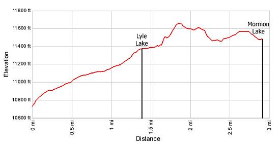
- Elevation: 10,730-ft. - 11,665-ft.
- Elevation Gain: 935-ft.
- Difficulty: moderate
- Trail Highlights: See Trail Intro
- Basecamp(s): Aspen
- Region: Central Colorado
This is one of the most scenic hikes in the Hunter-Fryingpan area. Starting at 10,730-ft., the trail climbs on moderate grades through acres of meadows awash in wildflowers to two beautiful lakes.
Trailhead to Mormon Lake
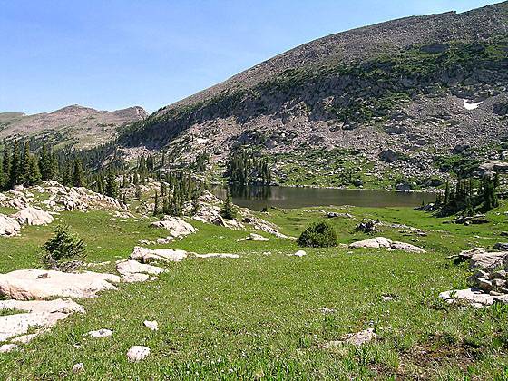
From the parking area (see driving directions) the trail heads northeast, ascending on moderate grades up a broad valley clad in wildflower-filled meadows sprinkled with trees. Just over a mile from the start the grade steepens as the trail curves left (north) and climbs a grassy draw to Lyle Lake (11,390-ft) at 1.4 miles. Pretty Lyle Lake is set in a granite bowl amid meadows scattered with trees.
To reach Mormon Lake cross Lyle’s outlet stream and follow the trail around the right (east) side of the lake where is crosses a small boulder field and then climbs to a saddle on the ridge at the north end of the lake. The climb, the steepest on this hike, gains 160-ft. in just under 0.3 miles. From the saddle views extend south to Mount Massive and a panorama of high peaks in the Mount Massive and Hunter-Fryingpan Wilderness areas.
At the top of the ridge the trail traverses rocky meadows along the western slope of an unnamed 12,367-ft. peak and then dips into and out of a bowl at the head of a small valley. The trail, now heading northeast, exits the bowl by ascending to a bench clad in alpine meadows. Cross the bench, passing to the left of a small tarn and then follow the trail as it descends 80-ft. to Mormon Lake.
Beautiful Mormon Lake lies nestled in a rocky basin beneath a steep granite ridge. Views extend northwest to the high peaks of the Holy Cross Wilderness. After taking a break, retrace your steps, enjoying the views and wildflowers on the return trip to the trailhead.
Elevation Profile
Buy the BookThis opinionated guide includes all the hikes in the Aspen, Buena Vista, Crested Butte, Marble and Leadville sections of the website plus info on local services and nearby attractions. | |
Driving Directions
Driving Directions from Aspen: From the corner of Mill Street and Main Street in Aspen, drive west on West Main Street/CO 82 W for 17.5 miles and turn right on 2 Rivers Road in Basalt. Travel on 2 Rivers Road for 0.8 miles to a stop light and turn right onto Midland Ave, which turns into the Fryingpan Road.
Drive 33 miles along the Fryingpan Road until the pavement ends. Bear left and go 10 more miles until you come to a sign pointing to Hagerman Pass. Turn left onto road #105 for 100 feet. Park by the bulletin board. The rough road can be driven by passenger cars but a 4WD vehicle is recommended. If you are in a passenger car it is best to check with the Forest Service on current road conditions.
Directions from Carbondale: From Carbondale travel east on Hwy 82 for 10 miles and turn left on 2 Rivers Road in Basalt. Travel on 2 Rivers Road for 0.8 miles to a stop light and turn right onto Midland Ave, which turns into the Fryingpan Road.
Drive 33 miles along the Fryingpan Road until the pavement ends. Bear left and go 10 more miles until you come to a sign pointing to Hagerman Pass. Turn left onto road #105 for 100 feet. Park by the bulletin board. The rough road can be driven by passenger cars but a 4WD vehicle is recommended. If you are in a passenger car it is best to check with the Forest Service on current road conditions.
Trail Resources
Trail Intro / Trail Photo Gallery / Trail Map
Basecamp(s) Information:
Aspen
Region Information:
Central Colorado
Other Hiking Regions in:
Colorado