Details: Mount Harvard 
Distance: 13.6 miles (round trip)
Collegiate Peaks, San Isabel, near Buena Vista in Central Colorado
Hike Facts
- Distance: 13.6 miles (round trip)
- Elevation: 9,890-ft. - 14,429-ft.
- Elevation Gain: 4,530-ft. - 4,539-ft.
- Difficulty: strenuous-difficult
- Trail Highlights: See Trail Intro
- Basecamp(s): Buena Vista
- Region: Central Colorado
A scenic trail with a steady ascent and short class-2 scramble leads to the summit of Mount Harvard (14,420-ft.) where hikers are greeted with stunning, panoramic views of five 14,000-ft. summits in the Collegiate Peaks and the surrounding valley.
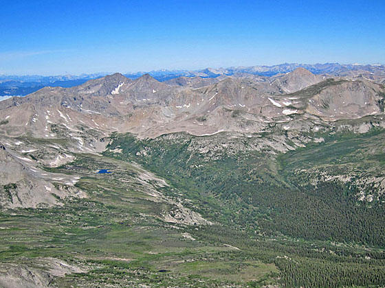
Trail to Mount Harvard
Note: Given the length and difficulty, the climb to Mt. Harvard is best done as a backpack. I recommend backpacking into the Horn Fork valley and then climbing the peak the next day. See the description of the Bear Lake trail for information on camping along the trail to the lake.
The easiest trail up Mt. Harvard, the third highest peak in Colorado, is accessed by the scenic trail climbing the Horn Fork Valley to Bear Lake (see driving directions below). Follow the first 5.2 miles of the Bear Lake trail to the junction with the trail to Mt. Harvard. At the junction turn right (north/northwest) toward Mt. Harvard. The trail to the left (west) leads to Bear Lake. (Note: The last time I hiked this trail the sign was missing from the junction.)
Follow the trail as it climbs steeply through rocky meadows and then talus slopes to a ridge extending east from Peak 13588 at 5.7 miles. Switchbacks help ease the climb to the ridge crest. Atop the ridge turn around for fine views of Bear Lake, Mt. Columbia, Mt. Yale and, in the distance, Mt. Princeton to the south. The grade now abates as the trail travels through alpine tundra along a bench. In season, the meadows are sprinkled with wildflower. Large rock cairns mark the trail.
At 5.9 miles the climb resumes, ascending steeply up the south facing slopes of Mt. Harvard toward the peak’s south ridge. Reach the ridge crest (13,590-ft.) at 6.25 miles. Turn right (north) and climb through rocky meadows along the right (east) side of the ridge. As you climb the meadows give way to scree covered slopes. At 6.7 miles reach the base of the summit block and the hardest part of the hike. From this point it is a Class 2 scramble up a steep slope covered with huge, stable rocks to the summit (14,420-ft.) at 6.8 miles. There are several routes to the summit. Take your time and select the route that works best for you.
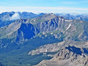
From the summit enjoy stunning views of the Sawatch Mountains and Collegiate Peaks Wilderness. Mt Yale forms the backdrop for the Horn Fork valley to the south. Mt Princeton and Antero Peak rise in the distance to the south. Mount Columbia towers above the valley to the southeast. The Buffalo Peaks dominate the view to the east while Mount Belford, Mount Oxford and Missouri Mountain rise above the Pine Creek valley to the north/northwest. In the distance a sea of peaks, including La Plata Peak, fill the skyline to the northwest. To the west is the distinctive profile of the Three Apostles.
When you are done enjoying the views retrace your steps to the trailhead. If time and energy allow, take a side trip to visit Bear Lake.
Preparing to Hike a 14er
Many hikers and climbers come to Buena Vista to summit one of the area’s 14,000-ft. peaks, known as 14ers. There are 58 14ers in Colorado ranging from hiking trails involving a minor amount of scrambling to technical climbing routes requiring ropes and related equipment. The Sawatch Mountains near Buena Vista, with 14 peaks over 14,000-ft., boasts the highest concentration of 14ers in the state.
Novice and casual hikers will be tempted by the challenge of summiting a 14er. It’s a great goal but you need to take the challenge seriously. To summit a 14er you must be in good physical shape and well acclimated. Flatlanders should not plan on arriving in Buena Vista and setting out the next day to summit a peak. The best strategy is to spend a week day hiking the many great trails around Buena Vista, pushing yourself to go higher each day.
Make sure you know the signs of altitude sickness and descend immediately to a lower altitude if symptoms develop. Seek medical help if the symptoms persist at lower altitude.
Get an early start. It is not unusual to see people starting a climb in the wee hours of the morning or at dawn. You will be hiking much slower than you expect. Allocate at least an hour for every 1,000-ft. of elevation gain. Your pace will slow to a crawl once you reach the rarefied air about 12,000-ft. Plan your time accordingly. It is best to be off the summit and below exposed terrain before the early afternoon to avoid thunderstorms, a frequent occurrence in the Rockies during the summer.
Some of the 14ers can be reached by a long day hike. These days will be much harder than you expect. I strongly recommend backpacking to a basecamp and then getting up early the next morning to summit a peak. This will cut down the distance and elevation gain required in a single day. Spending the night at a high altitude will also help you to acclimate.
Check the weather forecast and don’t try to summit if bad weather is imminent. Getting caught in a storm is not fun and can be dangerous. Make sure you take plenty of warm clothing, including a hat and gloves. Rain gear including pants is a must. A map, compass and safety equipment, such as matches, a first aid kit, knife and headlamp, are strongly recommended. The Gear list on the 14ers.com website includes an excellent packing list.
Be sure to take plenty of food and water to maintain your energy level and stay hydrated. Carry two to three quarts of water per person, tons of energy bars or other sources of protein and a substantial lunch.
Pick a 14er that matches your experience level. Plan the route and know what to expect. Read trip reports to learn about the terrain. The 14ers.com website includes an amazing trove of great information on climbing Colorado’s 14,000-ft. peaks.
Before your trip leave an itinerary with friend or a relative. Make sure someone knows where you are going and when you are going to be back.
Once you set out, don’t be afraid to turn around if in doubt. It always disappointing to turn around but if the weather is threatening, the trail is covered in slick snow/ice, you’re feeling unwell or you’re just uncomfortable on the trail, it is the right decision. Be smart, the mountain will be there for another attempt at some later date.
Note: Grades are assigned to climbs based on their difficulty. A Class 1 climb is really just a hike. A Class 2 climb is a more difficult hike up steep slopes, over boulder fields and/or ascending loose scree slopes. The route may involve some scrambling, with the possible use of the hands. There may be some exposure along the route.
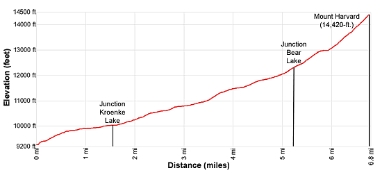
Elevation Profile
Buy the BookThis opinionated guide includes all the hikes in the Aspen, Buena Vista, Crested Butte, Marble and Leadville sections of the website plus info on local services and nearby attractions. | |
Driving Directions
Driving Directions from Buena Vista: From the traffic light at the intersection of U.S.24 and Country Road 306 in downtown Buena Vista, drive north on U.S. 24 W for three blocks (0.7 miles) and turn left on Crossman Avenue (CR 350). The turn is just beyond the Super 8 in Buena Vista.
Follow CR 350 for 1.8 miles to a “T” intersection and turn right on CR 361. Drive on CR 361 for 0.9 miles to a 2nd “T” intersection and turn left on CR 365. Follow CR 365 for 5.1 miles to the North Cottonwood Creek trailhead at the end of the road. The road gets noticeable rougher after the first 2.0 miles. Beyond this point normal passenger cars can make it to the trailhead if driven carefully. High clearance is better.
This is a very popular trailhead providing access to Mt. Harvard. As such it fills early in the morning during the summer. Additional parking is available along the road leading to the parking lot. Be sure to pick a spot that is well off the road.
Trail Resources
Trail Intro / Trail Photo Gallery / Trail Map
Basecamp(s) Information:
Buena Vista
Region Information:
Central Colorado
Other Hiking Regions in:
Colorado