Details: Frigid Air Pass 
Distance: 9.6 miles (round trip)
Maroon Bells-Snowmass Wilderness, White River National Forest, near Crested Butte in Central Colorado
Hike Facts
- Distance: 9.6 miles (round trip)
- Elevation: 10,420-ft. - 12,415-ft.
- Elevation Gain: 1,995-ft.
- Difficulty: moderate-strenuous
- Trail Highlights: See Trail Intro
- Basecamp(s): Crested Butte
- Region: Central Colorado
Hikers ascending the beautiful East Fork Valley to Frigid Air pass are rewarded with stunning views of the Maroon Bells, Snowmass Mountain and the nearby peaks of the Elk Mountains. In season the East Fork is famous for its spectacular displays of wildflowers.
Trailhead to Frigid Air Pass
The trail to Frigid Air Pass starts at the East Fork trailhead. (See driving directions.) Follow the trail as it heads east through spruce trees along the north side of the East Fork of the Crystal River. Soon the trail curves to the left (northeast) and leaves the river behind as it climbs switchbacks on moderate grades. The trees thin as the trail reaches an old mining cabin at 0.3 miles. A short distance beyond a sign marks the boundary for the Maroon Bells-Snowmass Wilderness.
At 0.4 miles the grade abates as the trail curves to the right (east) and begins an ascending traverse through meadows along the north side of the East Fork valley, high above the river. Views open to Mt. Bellview (12,519-ft.) to the southeast, Mount Baldy (12,805-ft.) and Cinnamon Mountain (12,933-ft.) to the southwest and Galena Mountain (12,580-ft.) to the west. Closer at hand, the meadows along the trail sport a spectacular display of wildflowers during late July and early August.
As you progress up the valley the trail crosses a few streams that are typically dry. At 1.2 miles the path crests a small rises and then descends briefly. At the bottom of the descent a faint, unmarked trail branches to the right (south). This trail eventually leads to Schofield Pass. We continue straight ahead, ascending the valley on moderate grades.
As you climb enjoy ever improving views of the peaks and ridges defining the head of the valley. Behind you, to the west/southwest, are fine views of Mt. Baldy, Cinnamon Mountain, Galena Mountain, Treasure Mountain and, in the distance, Purple Mountain and the summits of the Ruby Range.
Reach a “Y” intersection at 2.0 miles. We bear right on the trail signed for West Maroon Pass. The unmarked trail to the left (northwest) climbs to Hasley Pass. Beyond the junction the trail climbs briefly and then curves to the right (east), contouring through lush meadows and clusters of low willows. Along the way cross a stream which is typically dry after the snow melts.
At 2.4 miles start a steep ascent through meadows and willow patches. As you climb the trail curves to the southwest. To the west are great views of Galena and Treasure Mountains.
The grade eases at 2.9 miles and now ascends on moderate grades, reaching a signed trail junction at 3.1 miles. Here the trail to West Maroon Pass continues straight ahead (southeast). We turn left (northwest) on the trail to Frigid Air Pass.
Follow the undulating trail as it ascends northwest through lovely meadows. To the west/southwest are gorgeous views of Galena Mountain, Treasure Mountain, Mount Baldy, Cinnamon Mountain and, in the distance, Purple Mountain and the other peaks of the Ruby Range. Peak 12648, a red, pyramid-shaped mountain, towers above the valley to the northwest.
Reach a junction near a small pond beneath Peak 12648 at 4.5 miles. Turn right (north) on the signed trail to Frigid Air Pass. The unsigned trail to the left (west) leads to Hasley Basin. The trail to the pass skirts the left (west) side of the pond and climbs very steep switchbacks to Frigid Air Pass (12,415-ft.) at 4.8 miles, gaining 365-ft in 0.3 miles. Trekking poles are extremely help, especially when descending this section of the trail.
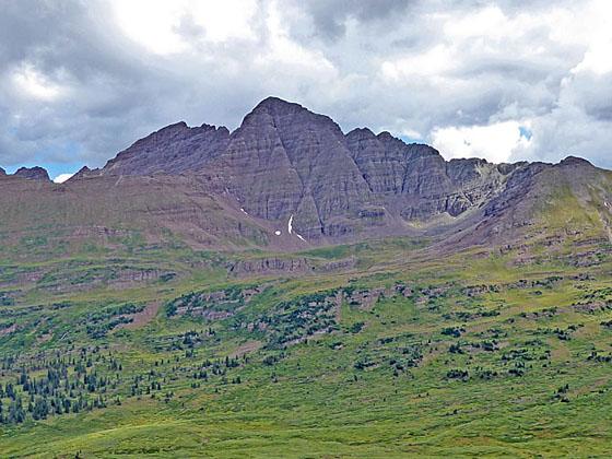
As you crest the pass stunning views open to the Maroon Bells towering above the emerald green meadows of the Fravert Basin. The white granite of Snowmass Mountain (14,092-ft.) and Hagerman Peak (13,841-ft.), dominating the view to the northwest, stands in sharp contrast to the crimson-brown mudstone of the Maroon Bells massif. Bellview Mountain (13,233-ft.) rises along the ridge at the head of Fravert Basin. Behind you, to the west/southwest, Mt Baldy, Treasure Mountain and Purple Mountain fill the skyline.
Find a perch atop the pass to rest and take in the views. The pass is the turnaround point for most day hikers. Expect to see plenty of backpackers at the pass. Backpackers cross Frigid Air Pass as part of the popular 26.6-mile Four Pass Loop, a 3-5 day backpacking trip climbing four 12,000-ft. mountain passes in the Maroon Bells-Snowmass Wilderness.
There are several options for the return leg of the hike. The easiest is to turnaround and retrace your steps for a 9.6 miles round trip (RT) hike. If time, energy and the weather permit, a side trip to West Maroon Pass is a great option. Extending the hike to West Maroon Pass will add 1.5 miles and 800-ft. in elevation gain to the hike. Total distance for the combined Frigid Air/West Maroon Pass hike is 11.1 mile RT. (See the West Maroon Pass from Crested Butte hiking description for more information.)
A second option is to follow the trail to the Hasley Basin Overlook for more great views. To reach the overlook descend from Frigid Air pass to the junction and turn right (west) on the unmarked trail toward Hasley Basin. Follow the narrow trail as it ascends on easy grades to a saddle at 5.5 miles, which I call the Hasley Basin Overlook, situated on the ridge between Peak 12648 and Peak 12345 to the west. Walking to the Hasley Basin Overlook and back will add 0.5 miles to the Frigid Air hike.
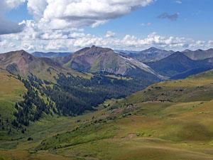
From the saddle enjoy panoramic views of Snowmass Mountain, Hagerman Peak and the summits rising above the Geneva Lake basin to the north. Below you are the beautiful green meadow of Hasley Basin. Along the ridge on the west side of the basin note the interesting stripped rock formation.
Behind you, to the east, Belleview Mountain towers above West Maroon Pass. To the northeast is Frigid Air Pass, where you will probably see hikers silhouetted against the skyline. When you are done enjoying the views retrace your steps to the trailhead.
Experience hikers comfortable with route finding can loop back from the Hasley Basin overlook to the East Fork trail on one of two routes for an 8.75-mile or 9.6 miles loop. See the Frigid Air – Hasley hiking description for more information on this option.
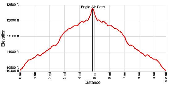
Elevation Profile
Buy the BookThis opinionated guide includes all the hikes in the Aspen, Buena Vista, Crested Butte, Marble and Leadville sections of the website plus info on local services and nearby attractions. | |
Driving Directions
Driving Directions from Crested Butte: From the intersection of Elk Avenue (main street) and 6th Street in Crested Butte, head north on 6th Street, which turns into the Gothic Road (sometimes referred to as the Schofield Pass Road). Follow the Gothic Road (CO 317) for 13.2 miles to Schofield Pass, passing the ski area and the research facilities at Gothic along the way. The dirt road is suitable for 2WD cars up to the town of Gothic at 7.9 miles. Beyond Gothic the road become rougher and a high clearance/4WD vehicle is required.
Continue over Schofield pass, descending the north side of the pass on switchbacks and then through meadows for 0.8 miles and turn right (east) into the signed East Fork trailhead. The turn is right before you hit Schofield Park, a large open park at the foot of the switchbacks. As you enter the trailhead, bear right into the parking area. The road branching to the left is for horse trailers.
Trail Resources
Trail Intro / Trail Photo Gallery / Trail Map
Basecamp(s) Information:
Crested Butte
Region Information:
Central Colorado
Other Hiking Regions in:
Colorado