Details: Geneva Lake 
Distance: 4.2 miles (round trip)
Maroon Bells-Snowmass Wilderness, White River National Forest, near Marble in Central Colorado
Hike Facts
- Distance: 4.2 miles (round trip)
- Elevation: 9,678-ft. - 10,985-ft.
- Elevation Gain: 1,307-ft.
- Difficulty: moderate
- Trail Highlights: See Trail Intro
- Basecamp(s): Marble
- Region: Central Colorado
This trail, our personal favorite, has waterfalls, wildflowers, a pristine lake and gigantic views of the Lead King Basin and backside of the Maroon Bells. Additionally, you can and should combine this trip with 4WD or ATV circumnavigation of the Lead King Basin road with stops in Crystal City and the Crystal Mill.
Trailhead to Geneva Lake
From the North Fork trailhead (see Driving Directions), hike north through pine forest. At 0.4 miles bear left on the Geneva Lake Trail. The trail wanders through meadows and trees for a mile. At the base of a switchback in a pretty meadow, views open to the waterfall on Geneva Lake’s outlet stream and Treasure Mountain (13,528-ft.) to the south.
The trail gets steeper for the next mile as it switchbacks up the hillside, enjoying awesome views of the water tumbling down the stream on your right. Near the top of the switchbacks look southeast for fine views of the Maroon Bells towering above the head of the North Fork Valley. Behind you are more great views of Treasure Mountain.
The trail then reenters a pine forest before breaking out along the meandering stream. Soon superb views open to Geneva Lake.
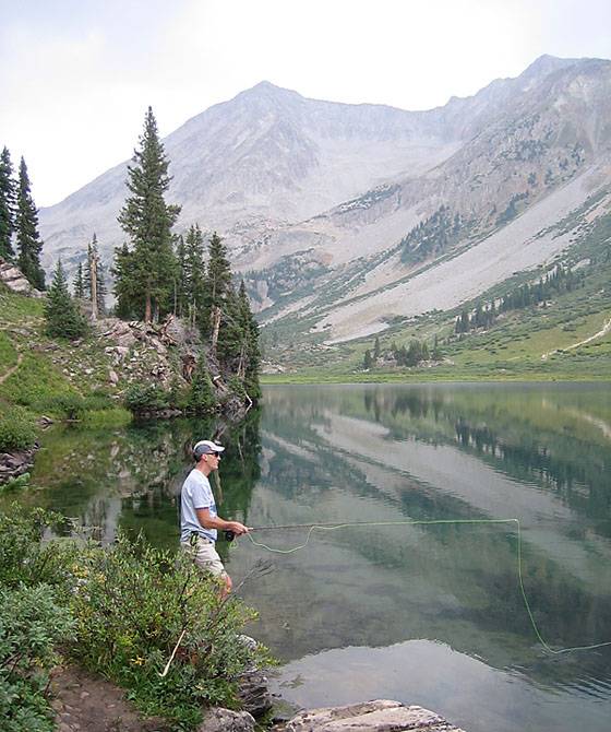
Reach Geneva Lake (10,985-ft.) at 1.6 miles after gaining a little over 1,300-ft. This beautiful alpine lake, surrounded by pretty meadows and subalpine firs, sits at the base of Snowmass Mountain (14,092-ft.) and Hagerman Peak (13,841-ft.). Treasure Mountain rises above the Crystal River Valley to the south.
The trail continues along the west side of the lake where it meets a boot beaten path to Little Gem Lake, another 1.25 miles up the valley. At the head of the lake the official trail turns right (southeast), crosses the inlet stream at 2.1 miles and then climbs over a low wooded saddle on Hagerman Peak's southwest ridge. On the climb to the saddle enjoy great views of Meadow Mountain to the west.
Beyond the saddle the trail traverses the hillside beneath Hagerman Peak's southeast ridge to a trail junction at 3.2 miles. Here the Geneva Lake trail branches left and climbs to Trail Rider Pass. To the left is the Cutoff trail descending to the North Fork trail. See the Four Pass Loop trail for more information on these connecting trails.
Use trails circumnavigate the lake providing fishermen access to various points along the shoreline to try their luck catching the cutthroat trout stocked by National Forest Service.
If staying overnight at Geneva Lake, advance reservation overnight permits are required and must be purchased in advance at recreation.gov. The lake is within the Maroon Bells-Snowmass Wilderness where bear containers are now required. See the regulations section at the end of the Four Pass Loop trail for more information and/or check out the White River National Forest Wilderness Regulations.
You can and should combine this trip with 4WD or ATV circumnavigation of the Lead King Basin road with stops in Crystal City and the Crystal Mill. We recommend hiking first and stopping in Crystal City after your hike to avoid afternoon thunderstorms. The road before and after Crystal City is rocky and rough, you’ve been warned!
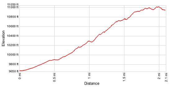
Elevation Profile
Buy the BookThis opinionated guide includes all the hikes in the Aspen, Buena Vista, Crested Butte, Marble and Leadville sections of the website plus info on local services and nearby attractions. | |
Driving Directions
From Marble: The Geneva Lake Trailhead is 7.5 miles from Beaver Lake in Marble on the Lead King Basin Road. Start in Marble, Colorado by renting an ATV, hiring the local Jeep Tours (Crystal River Jeep Tours) or driving a high clearance 4WD. Combine this trip/hike with a return stop in Crystal City and take some pictures of the Crystal Mill.
If you are driving to the trailhead from Marble: Drive through Marble, following the signs for Crystal City. Proceed past Beaver Lake east, climb rocky and rugged Daniel’s Hill and go left at the intersection for Lead King Basin. The road to the right goes to Crystal City. The road is 4WD only all the way to the trailhead. (Note: The road to Crystal City will also get you to the trailhead. The road to the left for Lead King Basin is more precarious, but the ride is smoother and faster if the road is dry. The right fork, the southern route to Crystal, is rough and the road is very difficult to negotiate beyond Crystal City.)
Follow the rough jeep road for 6.5 miles, bearing left at the first junction and right at the second junction. Beyond the second junction the road climbs over a pass (10,900-ft.) and then descends into the Lead King Basin. The Geneva Lake trailhead is located on the left side of the road, just before the road reaches the valley floor.
While driving to the trailhead we recommend stopping and taking some pictures at the highpoint (10,900 feet) before descending into Lead King Basin. Another short diversion is to hike the Silver Creek Trail to take pictures. The views are great from the start. Silver Creek Trailhead is 0.3 miles from the highpoint (10,900) on the Lead King basin side of the mountain.
From Aspen: Head West on CO-82 for 35 miles and turn left (south) on Colorado Hwy 133. Follow CO-133 for 25 miles, passing Carbondale, and turn left on County Road 3. Travel along CR-3 for 6 miles to the town of Marble. The Geneva Lake Trailhead is 7.5 miles from Beaver Lake in Marble on the Lead King Basin Road. Start in Marble, Colorado by renting an ATV, hiring the local Jeep Tours (Crystal River Jeep Tours) or driving a high clearance 4WD. Combine this trip/hike with a return stop in Crystal City and take some pictures of the Crystal Mill.
If you are driving to the trailhead from Mable: Drive through Marble, following the signs for Crystal City. Proceed past Beaver Lake east, climb Daniel’s Hill and go left at the intersection for Lead King Basin (left) and Crystal City (right turn). The road is 4WD only until you reach the trailhead. (Note: The road to Crystal City will also get you to the trailhead. The road to the left for Lead King Basin is more precarious, but the ride is smoother and faster if the road is dry. The right fork, the southern route to Crystal, is rough and the road is very difficult to negotiate beyond Crystal City.)
Follow the rough jeep road for 6.5 miles, bearing left at the first junction and right at the second junction. Beyond the second junction the road climbs over a pass (10,900-ft.) and then descends into the Lead King Basin. The Geneva Lake trailhead is located on the left side of the road, just before the road reaches the valley floor.
While driving to the trailhead we recommend stopping and taking some pictures at the highpoint (10,900 feet) before descending into Lead King Basin. Another short diversion is to hike the Silver Creek Trail to take pictures. The views are great from the start. Silver Creek Trailhead is 0.3 miles from the highpoint (10,900) on the Lead King basin side of the mountain.
Trail Resources
Trail Intro / Trail Photo Gallery / Trail Map
Basecamp(s) Information:
Marble
Region Information:
Central Colorado
Other Hiking Regions in:
Colorado