Details: Alpine Mine Overlook 
Distance: 5.6 miles (round trip)
Uncompahgre National Forest, near Ouray in Southwest Colorado
Hike Facts
- Distance: 5.6 miles (round trip)
- Elevation: 8,750-ft. - 10,930-ft.
- Elevation Gain: 2,180-ft.
- Difficulty: moderate-strenuous
- Trail Highlights: See Trail Intro
- Basecamp(s): Ouray
- Region: Southwest Colorado
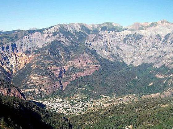
Hikers completing the stiff climb to an overlook 3,000-ft. above Ouray are rewarded with panoramic views of Ouray, the amphitheatre and the sea of peaks and ridges rising to the east of town.
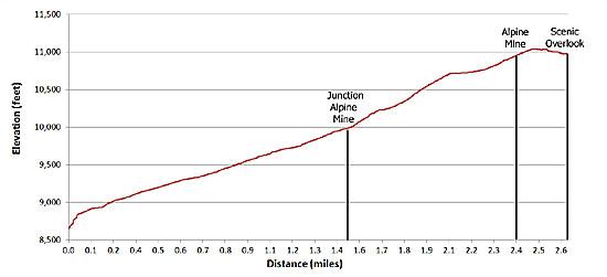
Trailhead to Junction with the Alpine Mine Trail
Distance from Trailhead: 1.5 miles (one way)
Ending/Highest Elevation: 9,980-ft.
Elevation Gain: 1,230-ft.
The trail to the Alpine Mine Overlook starts at the Weehawken trailhead (see driving direction). Follow the trail as it ascends moderate to moderately steep switchbacks through a forest of aspen and mixed conifers up the hillside to the north of Weehawken Creek. As you climb the trees give way to open meadows interspersed with aspen groves. The meadows provide nice views of Hayden Mountain across Canyon Creek valley. After about a mile of hiking the trees thicken and restrict the views.
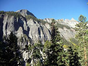
Reach a junction with the Alpine Mine trail at 1.5 miles. Before turning right on the Alpine Mine trail continue a few feet up to the Weehawken trail to a clearing that provides nice views of the cliff face forming the western wall of the Weehawken drainage.
Junction to Alpine Mine Overlook

Distance from Trailhead: 5.6 miles (round trip)
Ending/Highest Elevation: 10,930-ft.
Elevation Gain: 2,180-ft.
Beyond the junction the trail continues its ascent on a series of short, steep switchbacks that gain over 700-ft in 0.7-miles. Toward the top of the switchbacks the trail traverses a steep meadow. At the top of the meadow views open to the sculpted hillside above the trail.
The grade abates a bit as the trail traverses the scree covered slopes of a steep drainage on a narrow footpath with some exposure. Reach the head of the drainage and the site of the Alpine Mine at 2.4 miles. Here you will see mining equipment and remnants of tracks for ore cars. Mine buildings are located in the trees above the trail.
Beyond the mine the path ascends 180-ft. in 0.2 miles to reach the top of a ridge and the high point of the trail at 10,950-ft. Follow the trail along the top of the dry ridge interspersed with mixed conifers to the first lookout point featuring great views to the southwest of Potosi Peak and the sculpted cliff face towering above Weehawken Creek. Hayden Mountain and the peaks and ridges along the Million Dollar Highway rise to the southeast.
Continue along the ridge to a sign marking the path through the trees to the Alpine Mine Overlook. The overlook features 180-degree panoramic views. Ouray lies deep in the valley below with a wall of cliffs and mountains rising to the east. The Amphitheater rock formation towers above the southeast end of town. Twin Mountains dominates the view to the north while the peaks along the Million Dollar Highway and Hayden Mountain fill the skyline to the south.
The overlook is quite exposed with sheer drop-offs. Care should be taken while ogling the scenery. This is not a good place for small children.
After admiring the view return the way you came.
Elevation Profile
| Buy the BookThis opinionated guide includes all the hikes in the Ouray, Telluride, Silverton and Lake City sections of the website plus info on local services and nearby attractions. |

Driving Directions
Driving Directions from Ouray: Drive south on US Highway 550 for approximately 0.25 miles. Turn right onto Colorado State Highway 361 (Camp Bird Road) and continue for another 2.7 miles to the Weehawken Trailhead on the right side of the road.
Trail Resources
Trail Intro / Trail Photo Gallery / Trail Map
Basecamp(s) Information:
Ouray
Region Information:
Southwest Colorado
Other Hiking Regions in:
Colorado