Details: Baldy Trail 
Distance: 6.8 - 7.9 miles (round trip)
Uncompahgre National Forest, near Ouray in Southwest Colorado
Hike Facts
- Distance: 6.8 - 7.9 miles (round trip)
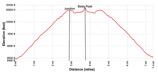
- Elevation: 8,485-ft. - 10,603-ft.
- Elevation Gain: 2,118-ft.
- Difficulty: moderate
- Trail Highlights: See Trail Intro
- Basecamp(s): Ouray
- Region: Southwest Colorado
The moderate hike to Baldy Peak features great views and an interesting perspective of the high peaks of the Ouray Region.
Trailhead to Baldy Peak
This trail description assumes you park in the field before the Baldy trailhead. (See driving directions below.) The last 0.3 miles to the trailhead require a high clearance, 4WD vehicle. If starting from the trailhead, subtract 0.3 miles from the one-way mileage in the description.
From the parking area in the field, return to the road junction and turn right. A steep descent down the road leads to a creek. Cross the creek and then ascend the continuation of the road on easy grades to the Baldy trailhead at 0.3 miles.
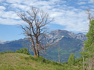
The trail quickly reaches a junction a short distance beyond the trailhead. Bear left at the junction on the Baldy Trail toward Baldy Peak. (The trail to the left is the Storm Gulch Trail.) Ascend a hillside clad in Gambel oaks and brushy meadows on moderate to moderately-steep switchbacks. The meadows offer views to the timbered hillsides lining the Cutler Creek drainage to the southeast.
At 0.8 miles the trail splits. Bear left at the split. The trail to the right is no longer used and becomes brushy and hard to follow before it rejoins the main trail. After hiking a mile we get our first views of Whitehouse Mountain (13,492-ft.) in the Sneffels range to the southwest. As you climb the trees give way to meadows and low shrubs. Views open to the Hayden Mountain (13,206-ft.) rising to the south of Ouray and the rugged ridge rimming the south side to Dexter Creek.
At 1.5 miles the trail curves to the right (northeast) and ascends a dry hillside to the top of a ridge at 1.8 miles. As you climb, enjoy ever improving views of the Sneffels Range.
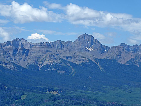
Atop the ridge the grade moderates. The path now follows an ascending traverse through meadows and spruce-pine forest along the ridge. Views expand to include Mount Sneffels in the Sneffels Range. The summits in the Uncompahgre Wilderness including distinctive Courthouse Mountain, Wetterhorn Peak (15,015-ft.) and Uncompahgre Peak (14, 309-ft.) fill the skyline to the east. To the south views extend to the Red Mountains along Highway 550 and the high peaks of Yankee Boy Basin.
At 2.9 miles the trail levels as it reaches a junction. To the right (east) is the Cutler Trail leading to the Storm Gulch trail and an alternative way back to the trailhead. We turn left (west) on the Baldy Peak Trail. Ahead Baldy Peak is the high point along the grassy ridge.
The trail now travels below the south side of the ridge crest. As you proceed enjoy more great views of the Sneffels Ranges, the summits in the Uncompahgre Wilderness and the high peaks to the south.
After walking about a half mile the trail traverses the slopes beneath Baldy Peak and then curves to the right, climbing to a saddle on the ridge to the west of Baldy at 3.6 miles. Here the trail fades. To the right is a grassy hillside leading to the top of Baldy Peak. Chart your own course up the slope to the top of Baldy Peak (10,603-ft.) at 3.7 miles.
The grassy summit features fantastic, albeit distant views. The Sneffels Range fills the skyline to the southwest. Courthouse Mountain, Wetterhorn Peak and the summits in the Uncompahgre Wilderness dominate the view to the east. Looking south, views stretch to Abrams Mountain, Brown Mountain, the Red Mountains and Storm King Peak. Hayden Mountain, Chicago Peak and the high peaks surrounding Imogene Basin tower above the south side of Yankee Boy Basin.
When you are done taking in the views, return to the junction of the Baldy Trail with the Cutler Creek Trail. You now have two options for returning to the trailhead. My preferred option is to retrace my steps on the Baldy Trail.
If you prefer to cover new ground, head east on the Cutler trail for 0.8 miles and then turn right (south) on the Storm Gulch trail. The Cutler trail fades as it enters the trees. It’s best to carry a map or GPS to stay on track. The descent on the Storm Gulch trail includes some steep, scree covered slopes. After 1.8 miles the Storm Gulch trail is joined by the Shortcut Trail. From here it is another 0.5 miles back to the Baldy trailhead. Returning via Cutler and Storm Gulch adds a half mile to the round-trip trail distance.
Elevation Profile
| Buy the BookThis opinionated guide includes all the hikes in the Ouray, Telluride, Silverton and Lake City sections of the website plus info on local services and nearby attractions. |

Driving Directions
Driving Directions From Ouray: From the center of Ouray (6th Avenue and Main Street), head north on Highway 550-N toward Ridgway for 2.1 miles and turn right onto the Dexter Creek Road. Follow the Dexter Creek Road for 1.0 mile as it climbs past a subdivision and then curves around past Lake Lenore on the right. A short distance beyond is a junction. Turn left here on County Road 14A and cross a bridge.
Country Road 14A now ascends, passing a few more homes. At 4.1 miles stay right where the road forks. The road to the left is Country Road 14B. You are now in the Uncompahgre National Forest and the road becomes a bit rougher. At 5.0 miles County Road 14B rejoins County Road 14A. The road now descends. Stay on the main road, ignoring any minor roads you pass. At 5.6 miles reach a junction. The road to the left descends steeply crosses a creek and then ascends to the trailhead at 5.9 miles.
The descent and crossing of the creek is only recommended for parties with a high clearance, 4WD vehicle. All other should continue straight ahead at the junction for short distance to an obvious parking area in a large field.
Trail Resources
Trail Intro / Trail Photo Gallery / Trail Map
Basecamp(s) Information:
Ouray
Region Information:
Southwest Colorado
Other Hiking Regions in:
Colorado