Details: Oak Creek 
Distance: 6.0 - 7.0 miles (round trip)
Uncompahgre National Forest, near Ouray in Southwest Colorado
Hike Facts
- Distance: 6.0 - 7.0 miles (round trip)
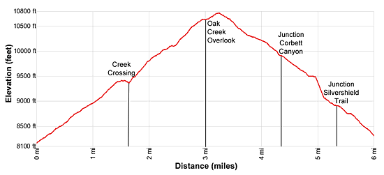
- Elevation: 8,150-ft. - 10,760-ft.
- Elevation Gain: 2,490-ft. - 2,610-ft.
- Difficulty: strenuous
- Trail Highlights: See Trail Intro
- Basecamp(s): Ouray
- Region: Southwest Colorado
Nice views of Hayden Mountain, Whitehouse Mountain and the Uncompahgre River Gorge are the highlights of this hike up pretty Oak Creek Canyon to an overlook on the southern flank of Twin Peaks.
Trailhead to the Overlook
Distance from Trailhead: 6.0 miles (round trip)
Ending/Highest Elevation: 10,640-ft.
Elevation Gain: 2,490-ft.
From the trailhead on South Pinecrest Drive in Ouray (see driving directions below), follow the trail as it climbs the hillside and soon passes the junction with the Perimeter trail branching off to the right. We continue ascending the Oak Creek Trail on moderate to moderately-steep switchbacks through oak, juniper and pine trees. Openings in the trees along the first two switchbacks offer views of the Amphitheater rising above the east side of downtown Ouray.
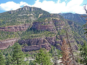
After a half mile views open up Canyon Creek (the Camp Bird Road) to the Hayden Mountain massif rising to the south and United States Mountain (13,036-ft.) towering above the Camp Bird Mine area to the southwest. Also visible are the rugged crags on the ridge extending from Peak 12,099 along the south side of Angel Creek.
Reach a trail junction at 0.9 miles. Here the Twin Peak Trail branches to the right. We bear left, continuing on the Oak Creek Trail. The path now ascends steeply through clusters of spruce, pine and aspen trees set amid small meadows. Intermittent views open to the jagged cliffs and knob of Sister Peak (10,798-ft.), one of the Twin Peaks, across the valley to the north. Hayden Mountain dominates the view to the south.
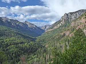
At 1.5 miles the climb ends and the path now follows a descending traverse along the south side of Oak Creek. At this point you can’t see the creek but you can hear it.
Soon views open to a pretty waterfall along Oak Creek. As the trail approaches the falls it curves to the right. Here views open down the length of Oak Creek Canyon to the cliffs rising above the east side of Ouray.
At 1.6 miles the path crosses the creek just above the waterfall. This area of the creek is a nice place to take a break and is a good destination for anyone looking for a short hike.
Beyond the waterfall the trail climbs a switchback up the north side of the creek and then turns left (west), following an undulating trail through trees above the north side of the creek. Along the way we pass some mine ruins. Use care along the first section of the trail where the path is eroded and the footing is not great. Look for two mine tunnels chiseled into a cliff face along the trail at 2.0 miles.
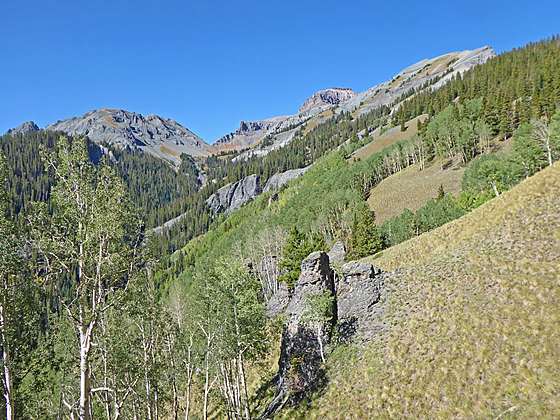
At 2.4 miles the path reaches a beautiful meadow rimmed by tall aspen and spruce trees. Here the trail curves to the right (north) and climbs steep switchbacks through meadows and clusters of trees. The trail is faint in places but generally not difficult to follow.
At 2.8 miles the grade abates a bit as the trail turns right (east) and crosses a drainage. As the trail climbs out the drainage fine views open to Whitehouse Mountain (13,492-ft.) towering above the valley to the west. Here you can also see up the Uncompahgre River Gorge to Abrams Mountain (12,801-ft.) and beyond.
The path now heads east, reaching the signed Oak Creek Overlook at 3.0 miles. Hayden Mountain towers above the valley to the south while Whitehouse Mountain fills the skyline to the west. Views extend southeast up the Million Dollar Highway and Engineer Pass Road. Across the valley to the east are the high summits rising above the Amphitheater.
The lookout is a great place to take a break or have a picnic lunch. From here you have two options, retrace your steps to the trailhead (6.0 miles round-trip) or continue on the Oak Creek trail to the Silvershield trailhead (7.0 miles including the one mile walk back to downtown Ouray). I personally prefer to return to the Oak Creek trailhead from the Overlook because of the better views.
Overlook to the Silvershield Trailhead
Distance from Trailhead: 7.0 miles (loop)
Ending/Highest Elevation: 10,760-ft.
Elevation Gain: -3,120-ft.
From the overlook, walk northwest on the Oak Creek trail in the direction of the Silvershield trail. The path climbs on moderate grades to a wooded saddle on the ridge at 3.2 miles (10,740-ft.). From the saddle the trail descends on moderate to steep grades through viewless forest.
At 4.3 miles reach the junction with the Corbett Canyon trail branching left. We turn right, continuing on the Oak Creek Trail. Beyond the junction the trail descends some very steep grades before arriving at the junction with the Silvershield Trail at 5.3 miles. This is the end of the Oak Creek Trail. To the right the Silvershield trail heads toward the Twin Peaks area. We continue straight ahead on the Silvershield Trail to the trailhead. Soon views open to Gold Hill's rugged cliffs towering above the east side of the Highway 550.
The path now drops steeply down dry hillsides to the Tamara Calhoon Memorial at 5.7 miles. Here a sign provides information about Gold Hill’s mining history and a bench offers a nice place to rest and enjoy the views.
Past the memorial the trail descends down dusty slopes to Oak Street at 6.0 miles. Turn right on Oak Street and walk about a mile back to the center of Ouray for a 7.0 mile loop hike.
Elevation Profile
| Buy the BookThis opinionated guide includes all the hikes in the Ouray, Telluride, Silverton and Lake City sections of the website plus info on local services and nearby attractions. |

Driving Directions
Driving Directions From Ouray: From 3rd Avenue and 1st Street in Ouray (corner of the Victorian Inn), head west on 3rd Ave. At the intersection with the Box Canyon Road, 3rd Avenue turns into Oak Street. Follow Oak Street for 0.1 miles as it crosses the bridge over the river and curves to the right. Turn left on Queen Street. Ascend Queen for one block and then turn left on South Pinecrest Drive. Ascend Pinecrest Drive for 0.4 miles to the Oak Creek/Twin Peaks Trailhead.
Alternatively, from Main Street and 7th Avenue in Ouray, head west on 7th Avenue for 0.2 miles and cross the river on a bridge. Beyond the bridge turn left on Oak Street. Follow Oak Street for 0.2 miles and the turn right onto Queen Street. Ascend Queen for one block and then turn left on South Pinecrest Drive. Ascend Pinecrest Drive for 0.4 miles to the Oak Creek/Twin Peaks Trailhead.
Note: There is very limited parking at the trailhead. You are better off parking in town and walking to the trailhead.
Trail Resources
Trail Intro / Trail Photo Gallery / Trail Map
Basecamp(s) Information:
Ouray
Region Information:
Southwest Colorado
Other Hiking Regions in:
Colorado