Details: Portland Trail 
Distance: 3.5 - 4.2 miles (round trip)
Uncompahgre National Forest, near Ouray in Southwest Colorado
Hike Facts
- Distance: 3.5 - 4.2 miles (round trip)
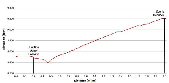
- Elevation: 8,500-ft. - 9,250-ft.
- Elevation Gain: 750-ft.
- Difficulty: easy
- Trail Highlights: See Trail Intro
- Basecamp(s): Ouray
- Region: Southwest Colorado
This short, easy loop hike explores the basin below a huge amphitheatre of eroded cliffs rising above the eastern side of Ouray and features scenic viewpoints to appreciate the formation along with the peaks rising to the south and west of town.
Portland Trail Out-and-Back
Distance from Trailhead: 4.2 miles (round trip)
Ending/Highest Elevation: 9,250-ft.
Elevation Gain: 750-ft.
There are several different access points to get on the Portland trail. I prefer starting at the Upper Cascade Falls trailhead, located at the top of the Amphitheatre Campground (see driving directions).
Follow the trail, which starts at the southeast end of the small trailhead parking area, for 0.2 miles as it contours along the hillside to a trail junction. Turn right at the junction on the Portland trail. The trail to the left, the Upper Cascade Falls trail, will be used as a return leg of the loop hike.
From the junction the trails descends to cross a normally dry drainage, climbs out the other side and starts ascending the basin on a series of gentle switchbacks. About a half a mile beyond the trailhead you will come to second trail junction. Continue heading northeast in the direction of the scenic overlook indicated on the sign. [The Portland trailhead, pointing to the southwest on the sign, leads to a second trailhead on the Portland Mine Road. This is a good starting point if the campground is closed (see driving directions below)].
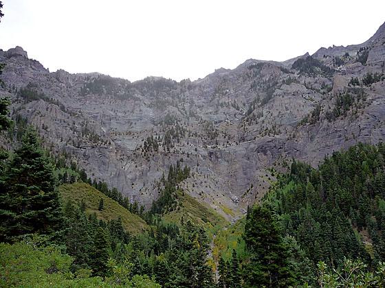
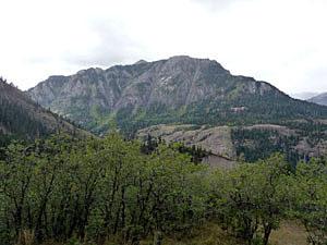
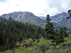
Beyond the junction the trail climbs through mixed conifers and small sections of scrub oak. Openings in the foliage feature nice views to the west and southwest toward Hayden Mountain and the peaks and ridgelines around Potosi Peak. About 1.7-miles from the campground trailhead an opening provides views across the drainage to a mining operation at the southern end of the Amphitheatre.
At the 2.0 mile mark a sign points to a scenic overlook with great views of the amphitheatre towering above the basin and Hayden Mountain. Shortly after the overlook (0.1-mile) reach a three-way trail junction.
Portland Trail with return via Upper Cascade Falls trail
Distance from Trailhead: 3.5 miles (loop)
Ending/Highest Elevation: 9,250-ft.
Elevation Gain: 750-ft.
Follow the directions above to the three way intersection. At the three way intersection you have several options. I recommend going left in the direction of the Amphitheatre Campground to complete the loop hike. The trail drops down to cross a normally dry drainage and then ascends to meet the Upper Cascade Falls trail in 0.6 miles. Go left at the Cascade Falls trail junction toward the Amphitheatre Campground. (The trail to the right climbs 1,100-ft in just under a mile on its way to Upper Cascade Falls and the Chief Ouray Mine.) At the next two junctions follow the signs back to the Campground and the trailhead parking area. See the Upper Cascade description for more information.
Another option is to take a side trip to the Portland Mine. To visit the mine head right at the three way junction, following the trail to the mine. The route drops about 150-ft to cross Portland Creek and then climbs to join the Portland Road in 0.5 miles. Follow the road east to the mine.
Finally, you can simply turn around at the three-way junction and return the way you came. The out-and-back hike is 4.2 miles (RT) from the campground or 3.8 miles (RT) from the trailhead on the Portland Road (see driving directions).
Elevation Profile
| Buy the BookThis opinionated guide includes all the hikes in the Ouray, Telluride, Silverton and Lake City sections of the website plus info on local services and nearby attractions. |

Driving Directions
From Ouray: Drive south from Ouray on Highway 550 for just over a mile to the Amphitheatre Campground and turn left onto the campground access road. The turnoff is past the second switchback leaving town. Follow the paved road into the campground for 1.25 miles, keeping left at all intersections. The trailhead, marked for the Upper Cascade trail, is located at the top of the campground. A good hand-drawn map on a signpost at the trailhead shows the interconnecting trail system that includes the Portland Trail, the Upper and Lower Cascade Falls trails and the Portland Mine Road..
If the access gate to the campground is closed you can reach the Portland trail by walking up the campground road or use two alternative access points. The first access point is reached using the Baby Bathtubs trail. After turning left onto the campground road look for a parking area on your left, right before a bridge. The Baby Bathtubs trail starts on the right side of the road just past the bridge. Follow this trail for just over 0.3 miles to where it meets the Portland trail.
This second access is on the Portland Road. From the Amphitheatre Campground road junction at U.S. 550 turn into the campground, follow the road for about 100 yards and turn right on the Portland Road, an unmarked dirt road. Follow the Portland Road for about 0.25 miles to the Portland Trailhead (the first road to the left). The section of the Portland trail crosses a small foot bridge over Portland Creek and ties into the loop trail system in a few hundred yards.
Trail Resources
Trail Intro / Trail Photo Gallery / Trail Map
Basecamp(s) Information:
Ouray
Region Information:
Southwest Colorado
Other Hiking Regions in:
Colorado