Details: Columbine Lake and Pass 
Distance: 7.0 - 8.9 miles (round trip)
San Juan National forest, near Silverton in Southwest Colorado
Hike Facts
- Distance: 7.0 - 8.9 miles (round trip)
- Elevation: 10,346-ft. - 13,094-ft.
- Elevation Gain: 2,748-ft.
- Difficulty: strenuous
- Trail Highlights: See Trail Intro
- Basecamp(s): Silverton / Ouray
- Region: Southwest Colorado
This little known hike climbs steeply through forest and beautiful alpine meadows to a stunning glacial lake set amid a backdrop of rugged 13,000-ft. peaks. Panoramic views from nearby Columbine Pass encompassing Bridal Veil Basin and the Sneffels Range.
Trailhead to the Saddle

Distance from Trailhead: 2.0 miles (one way)
Ending/Highest Elevation: 12,541-ft.
Elevation Gain: 2,195-ft.
The Columbine Lake hike wastes no time gaining elevation. From the trailhead, marked by a blaze on a tree (see driving directions), the path ascends steep switchbacks through spruce-fir forest. After climbing 1.3 miles and gaining over 1,100-ft. the grade abates a bit and the trees thin. Views open to a narrow alpine basin carpeted in meadows sprinkled with wildflowers.
After leaving the last of the trees behind the steep climb resumes up the middle of the basin. Be sure to turn around and enjoy ever improving views of the high peaks rise above the east side of Highway 550.
At the head of the basin the trail curves to the left (southwest) and then right (north), climbing through rocky meadows and scree to reach a saddle on a ridge at 12,541-ft., about 2.0 miles from the trailhead. Turn around just before reaching the saddle and check out the nice views to the east/southeast of Ohio Peak (12,673), Anvil Mountain (12,537-ft.) and Storm Peak (13,487-ft.).
Saddle to Columbine Lake
Distance from Trailhead: 7.0 miles (round trip)
Ending/Highest Elevation: 12,693-ft.
Elevation Gain: 2,347-ft.
The worst of the climbing is now over. The trail drops off the saddle and curves to the left (west), entering the Mill Creek drainage. Looking northeast on a clear day you will see the tips of the 14ers in the Uncompahgre Wilderness. Below is the Chattanooga Loop on Highway 550.
The trail now traverses a meadow and passes a few small tarns as it contours beneath the ridge defining the basin’s southern wall. Views extend across the basin to the peaks and ridges to the north and west.
At 2.4 miles (about 0.2 miles from the saddle), the trail reaches a "Y" intersection at a small rock cairn. Here a faint trail branching right (northwest) toward Columbine Pass drops down into the drainage, crosses a stream (Mill Creek) and then climbs the hillside above Mill Creek, heading for the obvious saddle (Columbine Pass) on the ridge. We bear left (west) on the trail to Columbine Lake. Ahead you will see two trails cutting across a scree slope. Both trails lead to the lake. Assuming the lower trail is snow free, follow that path as it contours around the scree pile and heads southwest, staying to left (east) of Columbine Lake’s outlet stream.
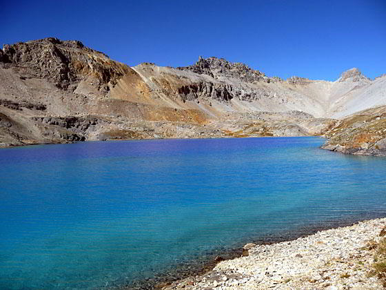
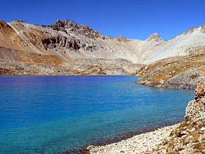
The trail now climbs steeply up the hillside beside the outlet stream. At the head of the outlet stream is a stone dam. As you climb around the dam and crest the hill Columbine Lake springs into view at 3.5 miles.
Columbine Lake is a turquoise jewel set in a stunning glacial bowl ringed by rugged 13,000-ft. ridges and peaks. Lookout Peak (13,661-ft.) rises above the southwestern end of the lake. The lake's shoreline invites exploration, providing multiple perspectives on the surrounding peaks. After taking a break, return the way you came or hike to the pass.
Columbine Lake to the Pass
Distance from Trailhead: 8.9 miles (round trip)
Ending/Highest Elevation: 13,094-ft.
Elevation Gain: 2,748-ft.
Columbine Pass is a recommended side trip for hikers with the time and energy. There is no established trail from the lake to the obvious pass, located on the ridge to the northwest of the lake, but route finding is fairly easy across the open country.
To reach the pass climb about 25-ft. to the top of the hillside running along the lake’s north shore and walk northwest, paralleling the lake. Near the end of the lake turn right (north), making a wide arc around a small tarn in a depression. Continue heading north, ascending through rocky meadows and aiming for the obvious saddle (pass) on the ridge.
Along the way you may find a few faint trails but they do not last very long. Continue your ascent until you hit a trail coming down from the pass. (The trail is not very obvious and you may not hit it at all depending on the route you take to the saddle.) If you hit the trail turn left (northwest) and follow the path to the saddle at 13,080-ft. The total distance to the pass is just under 1 mile with a 400-ft. elevation gain.
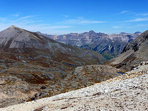
From the top of the pass enjoy a bird’s eye view into Bridal Veil basin on the west side of the pass. (A trail from the pass leads down to the basin and Lewis Lake (12,720-ft.). Mt. Sneffels (14,150-ft.) and the Sneffels Range dominate the view to the north/northwest. To the southeast are distant views of the high peaks of the Grenadier Range.
After taking in the panoramic views, retrace your steps back to the lake and then follow the trail back to the trailhead.
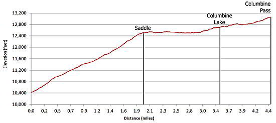
Elevation Profile
| Buy the BookThis opinionated guide includes all the hikes in the Ouray, Telluride, Silverton and Lake City sections of the website plus info on local services and nearby attractions. |

Driving Directions
Driving directions from Silverton: Drive 4.8 miles north from Silverton on Highway 550 to the Ophir Pass Road (County Road 8) on the left. Turn left on the Ophir Pass road and follow it across a bridge. Shortly after crossing the bridge turn right on to Forest Road 820. Drive 0.7 miles to the trailhead located just beyond a wide part of the road. Park on your right at the wide spot and walk up the road (north) a brief distance to the trailhead marked by a blaze on a tree. Here an an obvious trail heads west uphill.
Driving directions from Ouray: Drive 16 miles south of Ouray on Highway 550 (4.3 miles beyond Red Mountain Pass) and make a sharp right on (Forest Road 820),a gravel road. After the sharp right (essentially a hairpin curve off the highway) you will be on a gravel road heading north, paralleling the highway. Follow the road for a brief distance as it drops down to and cross a bridge over a creek. Beyond the bridge the road curves to the left (northwest) and climbs switchbacks up the hillside. Soon the road turns left (south) and levels out. Just pass a very narrow section of the road watch for a blaze on a tree to your right and a trail heading uphill (west) through the trees. Drive about 150-feet beyond the trailhead and park on the left at a wide spot in the road.
Note: Avalanches and mud slides have created a narrow section on the road, a short distance before the trailhead. There are also good parking spots along the left side of the road before you reach the narrow spot.
Trail Resources
Trail Intro / Trail Photo Gallery / Trail Map
Basecamp(s) Information:
Silverton / Ouray
Region Information:
Southwest Colorado
Other Hiking Regions in:
Colorado