Details: Spencer Basin 
Distance: 4.2 - 7.7 miles (round trip)
Gunnison BLM, near Silverton in Southwest Colorado
Hike Facts
- Distance: 4.2 - 7.7 miles (round trip)
- Elevation: 10,830-ft. - 12,940-ft.
- Elevation Gain: 1,390-ft. - 2,110-ft.
- Difficulty: moderate-strenuous
- Trail Highlights: See Trail Intro
- Basecamp(s): Silverton
- Region: Southwest Colorado
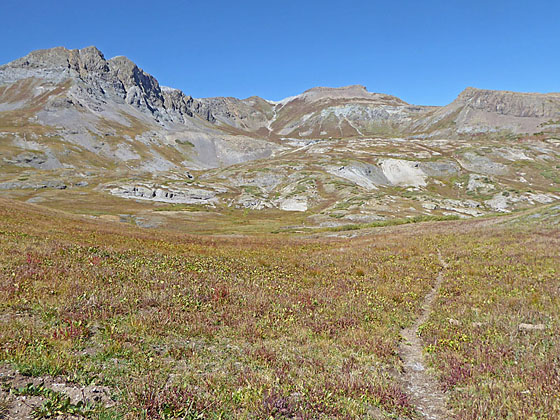
An old mining road leads to the heart of Spencer Basin, a beautiful, unspoiled and seldom visited valley surrounded by 13,000-ft. peaks. Here use trails and routes lead to two scenic passes.
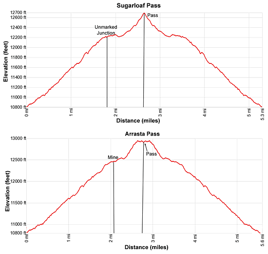
Trailhead to Sugarloaf Pass Junction
Distance from Trailhead: 1.8 miles (one way)
Ending/Highest Elevation: 12,220-ft.
Elevation Gain: 1,400-ft.
Note: Hikers in low clearance vehicles should park at the mine ruins near the end of County Road 4 and walk 0.8 miles up the road to the trailhead. (See driving directions below.) Walking the road will add 1.6 miles round-trip to the distance and 380-ft. to the elevation gain.
From the Spencer Basin trailhead parking area (see driving directions below), walk uphill on the dirt road, climbing moderately-steep switchbacks. You will cross Mountaineer Creek twice in the first 0.25 miles. At 0.4 miles keep left, the road branching right ends at a tram tower, visible above the trail to the north. A few more switchbacks bring you to a huge tailings pile blocking the road near a small parking area (2-3 cars).
Climb over/around the tailings on a boot beaten path leading to the continuation of the road. The road now heads southwest, ascending steeply for a short distance before crossing a gully. Beyond the gully the grade moderates as the path climbs through meadows and low shrubs. Turn around for nice views of Cunningham Gulch and Green Mountain (13,049-ft.).
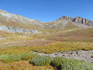
After a mile the road curves to the right (west) and views open up to Peak 13,434-ft. at the head of the valley. Soon the road swings to the left and then the right. Ahead is a large rock formation. A tributary of Mountaineer Creek flows around the left (south) side of the formation and joins the main branch of Mountaineer Creek below the trail. The road now climbs steeply through white-colored rock along the right (north) side of a gully channeling the main branch of Mountaineer Creek. Ahead are views of Peak 13,409-ft. at the head of the valley.
The grade abates as the road reaches the top of a hill, crosses Mountaineer Creek and then swings to the left (southwest), ascending through meadows and scattered clusters of willows. To the south views open to Surgarloaf (12,754-ft.) and an unnamed peak to the west.
At 1.7 miles the road swings left (south) around a large rock outcropping. This feature is important in finding the trail/route climbing to the pass west of Sugarloaf. Soon the road starts curving to the right and widens. Now watch for an unmarked trail branching left (south) through a clump of willows at 1.8 miles. This is the trail to the pass.
Here you will have great views of the gray-colored ridge rimming the south side of Spencer Basin. The high peak with a squarish top anchoring the southwest end of the ridge is Mount Rhoda (13,402-ft.). Peak 13,434 rises to the north of Rhoda. Surgarloaf is the roundish peak anchoring the southeast end of the ridge. The pass, which I refer to as Sugarloaf Pass, is the saddle to the right (west) of Sugerloaf.
You now have a choice of walking to Sugarloaf Pass or continuing up the valley. With an early start, fit hikers can accomplish both options in one day.
Here is the mileage and elevation gains for the various options:
- 4.2 mile to the Mine (12,420-ft.) / +1,590-ft.
- 5.4 miles RT to Sugarloaf Pass (12,690-ft.) / +1,860-ft.
- 5.6 miles to Arrasta Pass (12,940-ft.) / +2,110-ft.
- 6.2 miles combining trip to the Mine and Sugarloaf Pass /+2,050-ft.
- 7.7 miles to both passes /+2,580-ft.
Climbing to Sugarloaf Pass
Distance from Trailhead: 5.4 miles (round trip)
Ending/Highest Elevation: 12,690-ft.
Elevation Gain: 1,860-ft.
To reach Sugarloaf Pass, turn left and follow the trail as it head south through pretty meadows with fine views of the ridge to the south and the peaks at the head of Spencer Basin. At 1.9 miles the trail curves to the left (southeast) and then crosses creek flowing through marshy meadows at 2.1 miles.
Beyond the creek the trail fades as it tracerses the meadows. To the left you will see some stakes. Don’t walk toward the stakes. Instead head across the marshy meadows, aiming for a low point between two hills.
At the far end of the marshy-meadows the trail becomes evident as it ascends a low rise, staying to the left (north) of the creek. After topping the rise the grade steepens as trail climbs toward the pass, passing a small pond along the way. The ascent is accompanied by great views of the cirque at the head of Spencer Basin and the ridge rimming the north side of the valley.
Reach Sugarloaf Pass (12,690-ft.), a saddle on the ridge, at 2.7 miles. From the pass enjoy fine views of the Highland Mary Lakes Basin to the south/southeast. The Needles rise to the south beyond the basin. To the north/west the high peaks towering above Spencer Basin dominate the view while the peaks looming above the Cunningham Creek Valley and beyond fill the skyline to the northeast.
A trail of sorts climbs along the ridge to the top of Sugarloaf. There is also a trail that continues heading southwest from the pass. This path traverses the basin beyond the pass and then becomes faint as it drops down to intersect a route along the east facing slopes of Mount Rhoda. I have met hikers who use this route to form a loop with the Highland Mary Lakes but have never done so myself. This route involves off-trail hiking and requires parties to carry good maps of the area. Large herds of sheep graze these meadows so expect a lot of animal tracks to lead you astray.
I advise turning around at the pass and either returning to your vehicle via the Spencer Basin trail or continuing further up Spencer Basin. Leave the Highland Mary Lakes hike, including the loop option with the Continental Divide Trail, for another day.
To the the Mine and Arrastra Pass
Distance from Trailhead: 5.6 miles (round trip)
Ending/Highest Elevation: 12,940-ft.
Elevation Gain: 2,110-ft.
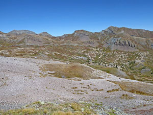
A short distance past the unmarked trail to Sugarloaf Pass the road again curves to the right and climbs steeply up a rocky hillside. The short climb ends atop a bench where the path turns to the left and ascends on easy to moderate grades.
At 2.1 miles reach a “Y” intersection with the remnants of a two-track road branching left. To the right is the mine (12,420-ft.), set amid a flattened gravel area. The hillside above is littered with tailings and a mine shaft. Straight ahead is a moist meadow with a stream and small pond. Scattered around the area are evidence of mining. Turn right and walk across the gravel toward the tailings, passing the ruins of a rock building.
Beyond the tailings a faint trail heads northwest up a grassy hill, staying to the right of a seasonal creek. Talus spills down the hill along the left side of the creek. At the top of the hill, at 2.2 miles, the trail disappears. To the left (west) is the cirque ringing the head of Spencer Basin. Straight ahead to the north is an obvious saddle on the ridge rimming the north side of the basin. The unnamed saddle, which I call Arrastra Pass, is to the right (east) of Peak 13409. Below is a marshy meadow.
Here again hikers have a choice, find a place to enjoy the views at the head of the valley before retracing your steps to the trailhead or climb the saddle to the north. There is no trail to the saddle so blaze your own route. I recommend initially curving around the left side of the marshy meadows and then keeping to the grass, as much as possible, as you climb the steep slopes to Arrastra Pass (12,940-ft.). It about 0.75 miles to the pass and will take a half hour or more (depending on your conditioning).
From the pass enjoy fine views of Silver Lake and the Arrastra Basin to the north. Little Giant Peak (13,416-ft.) towers above the east side of the lake while Kendall Peak (13,451-ft.) rises to the west. When you are done enjoying the views, retrace your steps to the trailhead.
Elevation Profile
| Buy the BookThis opinionated guide includes all the hikes in the Ouray, Telluride, Silverton and Lake City sections of the website plus info on local services and nearby attractions. |

Driving Directions
Driving directions from Silverton: Drive northeast through Silverton on Greene Street, the town’s main street, pass the courthouse (on the left) and bear right on County Road 2 toward Howardsville. The road is paved for the first 2.0-miles and then turns to a good gravel surface. Just before reaching Howardsville, turn right on County Road 4 (marked with a sign for the Old One Hundred Mine Tour). Follow CR 4, a good dirt road, for 3.7 miles up Cunningham Gulch to the ruins of a mine.
Note: County Road 4 splits part-way up Cunningham Gulch. Either road will get you to the trailhead. The road to the right (lower road) is easier.
Hikers in low clearance vehicles should park off the road near the mine and walk up the road about 0.8 miles, gaining about 380-ft., to the trailhead. If walking the road, add 1.6 miles to the round-trip to the trail distance.
The road crosses a bridge and then starts climbing up the right (west) side of the creek with the aid a long switchback. (The road gets rougher and steeper as it climbs. Vehicles with AWD/4WD with good clearance are recommended.) Follow the road for a little over 0.8 miles to an intersection with a road splitting off to the left. Continue past this intersection to an obvious parking area on your left.
It is possible to continue up the road another 0.5 miles to a small parking area that holds 2-3 cars. You will need to ford two streams, potentially problematic during high water. It is a nice walk and a short enough hike that I advise walking.
Driving Directions From Ouray: Follow U.S. Highway 550 South from Ouray for 29 miles to the turnoff to Silverton and then follow the Silverton directions (above) to the trailhead.
Trail Resources
Trail Intro / Trail Photo Gallery / Trail Map
Basecamp(s) Information:
Silverton
Region Information:
Southwest Colorado
Other Hiking Regions in:
Colorado