Details: Iron Mountain 
Distance: 8.0 miles (round trip)
Uncompahgre National Forest, near Telluride in Southwest Colorado
Hike Facts
- Distance: 8.0 miles (round trip)
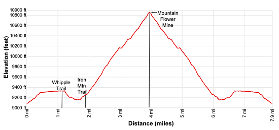
- Elevation: 9,090-ft. - 10,857-ft.
- Elevation Gain: 1,767-ft.
- Difficulty: moderate-strenuous
- Trail Highlights: See Trail Intro
- Basecamp(s): Telluride
- Region: Southwest Colorado
Iron Mountain climbs a steep mining road with fine views of the surrounding mountains along with Wilson Peak and the Lizard Head Wilderness. Aspen groves, waterfalls and an old mine add interest to the hike.
Trailhead to Mountain Flower Mine
Access to the Iron Mountain Trail is via the Deep Creek Trail. (See driving directions below). From the trailhead, walk north/northeast on the Deep Creek Trail ascending moderate switchbacks through meadows. The high peaks of the Lizard Head Wilderness, including Wilson Peak (14,017-ft.) and Sunshine Mountain (12,930-ft.), dominate the view to the southwest. Whipple Mountain (11,992-ft.) and the unnamed peaks rising along the west side of the Deep Creek fill the skyline to the northwest.
After 0.3 miles reach an unsigned junction on a dirt road and turn left. Make note of this intersection so you don’t miss your turn on the way back to your vehicle.
At 0.4 miles the grade levels as the trail reaches a signed junction for the Deep Creek Trail where a road joins from the south. Continue straight ahead (northwest) through trees on the Deep Creek Trail that now runs along an irrigation ditch.
At 1.2 miles reach a signed junction and turn left (west) on the Whipple Trail. Openings in the trees along the trail offer fine views of Wilson Peaks and the Lizard Head Wilderness. A tenth of a mile beyond the turn reach a small sign pointing to the continuation of the trail dropping down a wooded hillside to a crossing of the East Fork of Deep Creek at 1.7 miles. Cross the creek on a wood log and then ascend a hillside to a dirt road at 1.8 miles.
Turn right (northeast) on the road, a two track, signed for the Iron Mountain Trail (#495). To the left is the continuation of the Whipple Mountain Trail.
The road now climbs on moderate to moderately steep grades through aspen groves and scattered evergreens above the north side of the creek. Ignore a trail branching right at 2.1 miles. This trail drops to the creek.
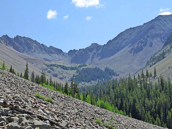
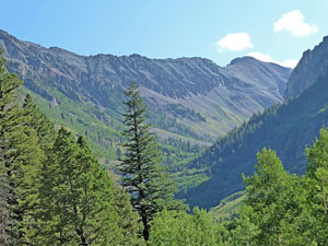
A short distance beyond the road becomes rocky as it crosses talus slopes. Here views open up the valley, known locally as Snodgrass Canyon after a local who died in the area in the 1940’s. Ruffner Mountain (13,003-ft.) and Mears Peak (13,496-ft.) tower above the north side of the valley.
Look for a waterfall along the creek at 2.8 miles. Over the next 0.4 miles the valley floor drops steeply down a series of steps, each with a photogenic falls. Some of the falls are difficult to see because of the dense foliage along the valley floor. Early in the morning the valley bottom is in deep shade, making photographing the falls difficult.
At 3.0 and 3.1 miles cross seasonal creeks flowing down the steep slopes above the trail. Beyond each of the crossings turn around for more nice views of the Lizard Head Wilderness. If you look closely you should be able to see Lizard Head Peak, a slender spire rising to the left of Sunshine Mountain.
As you continue ascending enjoy ever improving views of Mears Peak. The trail is now gradually curving to the right (east), opening views to the rugged summits forming the cirque at the head of the valley.
At 3.2 miles you will see to a section of burnt timber below the trail. Here is another good place to see a waterfall along the creek. Across the valley the rugged ridge and summits of Iron Mountain (12,747-ft. and 12,525-ft.) tower above the falls.
After passing through a pretty meadow a short section of the road becomes overgrown but it still clear. Beyond this point the road surface turns rocky as it ascends along talus slopes and enters a spruce forest. Watch for a pile of limbs blocking the road at 3.5 miles. Here the road makes a sharp left turn and climbs a rocky switchback. Rock cairns help mark the turn.
The trees soon give way to rocky slopes as you climb the switchback. Great views open to Iron Mountain across the valley. At 3.6 miles reach a second pile of branches marking a sharp turn to the right. A short overgrown section of the trail impedes progress ahead but beyond the brush the trail is again clear.
The trail now heads northeast again, climbing on moderately-steep to steep grades up rocky slopes through scattered trees. Soon the trees give way to open talus slopes and nice views open to the rugged 13,000-ft. peaks at the head of the valley. Iron Mountain dominates the view across the valley. Multi-hued Ruffner Mountain soars above the trail. The Wilson Peak massif fills the skyline to the southwest.
At 3.9 miles the trail splits, stay left here, taking the high route which reaches the Mountain Flower Mine tunnel (10,857-ft.) at 4.0 miles. A piece of metal equipment sits atop a large tailings pile in front of the mine, which also serves as a great overlook and a fine spot for lunch. Below the tailings pile are the collapsed wood ruins of an old cabin and a small building, probably the outhouse. Rusted mining remnants and household items, such as cans and bottles, are strewn across the ground around the cabin area. Please don’t take any souvenirs. Leave everything where you found it.
From the tailings pile enjoy fine views of Snodgrass Canyon. Iron Mountain rises directly across the valley. Campbell Peak (13,213-ft) anchors the southeast end of the cirque. Ruffner Mountain and Mears Peak rims the valley to the north.
It is possible to continue hiking up the valley. A trail takes off through the talus above the cabin site. The trail is faint and easily lost as it climbs along open talus slopes and meadows on the north side of the valley before climbing a series of benches populates with stands of Engelmann spruce. The talus/scree near the head of the canyon is loose and unstable, making for difficult scrambling.
Elevation Profile
| Buy the BookThis opinionated guide includes all the hikes in the Ouray, Telluride, Silverton and Lake City sections of the website plus info on local services and nearby attractions. |

Driving Directions
Driving directions from Telluride: From West Colorado Avenue and Aspen Street in Telluride, head west on W. Colorado Ave. for 3.2 miles and then bear right onto Airport Road / Last Dollar Road. This turn is right before the traffic circle (Society Turn) where West Colorado Ave reaches CO 145. Follow Airport/Last Dollar Road for 1.9 miles and turn right onto the continuation of Last Dollar Road. This turn is just before you reach the Telluride Airport.
Follow Last Dollar Road for 1.0 mile to the Deep Creek Trailhead on the right (east) side of the road. The marked trailhead is located at the north end of the circular spur road.
Trail Resources
Trail Intro / Trail Photo Gallery / Trail Map
Basecamp(s) Information:
Telluride
Region Information:
Southwest Colorado
Other Hiking Regions in:
Colorado