Details: Lake Hope 
Distance: 4.5 - 5.9 miles (round trip)
Uncompahgre National Forest, near Telluride in Southwest Colorado
Hike Facts
- Distance: 4.5 - 5.9 miles (round trip)
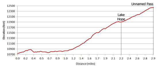
- Elevation: 10,750-ft. - 11,880-ft.
- Elevation Gain: 1,130-ft. - 1,695-ft.
- Difficulty: moderate
- Trail Highlights: See Trail Intro
- Basecamp(s): Telluride
- Region: Southwest Colorado
This popular hike to a high alpine lake surround by 13,000-ft. peaks offers panoramic views of the Wilson Range and the high peaks in the Lizard Head Wilderness.
Trailhead to Lake Hope
Distance from Trailhead: 4.5 miles (round trip)
Ending/Highest Elevation: 11,880-ft.
Elevation Gain: 1,130-ft.
The Lake Hope trail, which starts at a sharp curve on a switchback on FS Road #627 (see driving directions below), ascends through spruce-fir forest on gentle grades up the east side of the Lake Fork Valley. A stream crossing at Poverty Gulch (0.3 miles) provides the first views of Sheep Mountain and San Miguel Peak (13,752-ft.) across the valley.
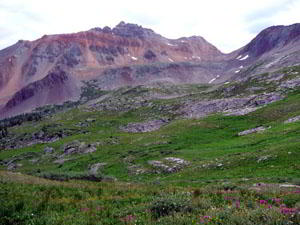
Continuing up the valley the path crosses rock slides and traverses small, wildflower-filled meadows that offer sweeping views of the 14'ers of the Wilson Range and the distinctive spire of Lizard Head Peak to the northwest. As you climb enjoy ever improving views of the peaks lining the south and west walls of the valley. To the east above to the trail a large rust-colored scree field spills off the shoulder of Vermilion Peak.
At the head of the valley the trail swings southwest through meadows filled with waist-high wildflowers. After crossing the third stream, about 45 minutes from the start of the hike, the trail begins a moderate-steep climb, aided by switchbacks, through woods up the headwall of the lake basin. Openings in the trees provide nice views of Trout Lake and nearby peaks.
After gaining 800-ft. in 0.6 miles the trees give way to beautiful meadows sprinkled with wildflowers. To your left (east) the skyline is dominated by Vermilion Peak, clad in red, rust and purple-gray rock, rising above the emerald green alpine basin.
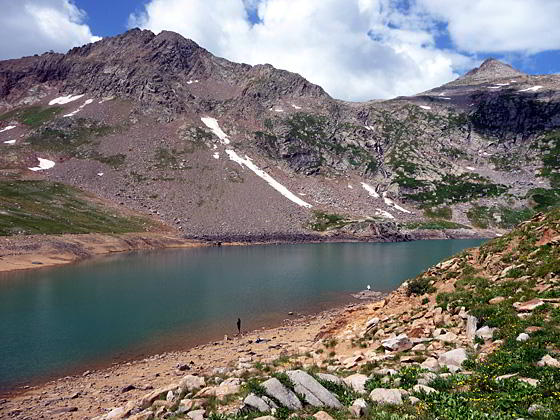
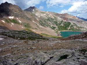
Lake Hope (11,880-ft.), at 2.25 miles, comes as somewhat of a surprise, springing into view as you crest a grassy slope between two rocky hills. The man-made lake, storing water for the Ames Power Plant, sits in a pretty cirque surrounded on three sides by 13,000-ft. peaks. Use trails extend along the lake's eastern shore to a dam at the north end of the lake.
Lake Hope to Unnamed Pass
Distance from Trailhead: 5.9 miles (round trip)
Ending/Highest Elevation: 12,445-ft.
Elevation Gain: 1,695-ft.
The trail to the pass above Lake Hope heads south around the left (east) side of the lake and soon starts climbing a moderately steep slope through meadows dotted with wildflowers. At 2.6 miles the trail swings east and switchbacks up a rocky hillside, reaching the unnamed pass in 0.7 miles after gaining 545-ft.
From the pass enjoy views of Rolling Mountain (13,693) to the south and the Twin Sisters (13,374 and 13,432) to the east. San Miguel Peak dominates the scenic ridge rising above Lake Hope to the west.
After taking a break return the way you came, enjoying the great views as you descend. Allow 4 to 4.5 hours for the round trip hike to the pass, including a lunch break.
Elevation Profile
| Buy the BookThis opinionated guide includes all the hikes in the Ouray, Telluride, Silverton and Lake City sections of the website plus info on local services and nearby attractions. |

Driving Directions
Driving directions from Telluride: From downtown Telluride drive 3 miles west on West Colorado Avenue (the main street) to the intersection with State Hwy 145 and turn left (south). Follow Hwy 145 for approximately 10.1 miles and take a left at the road signed for Trout Lake (Forest Road #626/ North Trout Lake Road). Follow the road around the northwest shore of Trout lake for approximately one mile to Forest Road #627. Turn left on #627. Proceed up this rough road for 2.5 miles to the Hope Lake Trailhead. The trailhead is located on the sharp curve of a switchback. (Note: High clearance vehicles are recommended for FS627. Passenger cars, if driven carefully, have successfully negotiated the road. It is best to check with the Forest Service about current road conditions.)
Trail Resources
Trail Intro / Trail Photo Gallery / Trail Map
Basecamp(s) Information:
Telluride
Region Information:
Southwest Colorado
Other Hiking Regions in:
Colorado