Details: Liberty Bell / Marshall Basin Loop 
Distance: 6.0 - 10.6 miles (loop)
Uncompahgre National Forest, near Telluride in Southwest Colorado
Hike Facts
- Distance: 6.0 - 10.6 miles (loop)
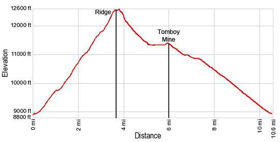
- Elevation: 8,880-ft. - 12,575-ft.
- Elevation Gain: 3,695-ft.
- Difficulty: strenuous
- Trail Highlights: See Trail Intro
- Basecamp(s): Telluride
- Region: Southwest Colorado
This lightly traveled trail climbs steeply to Liberty Bell basin and a scenic ridge. Extend the hike by descending the Marshall Basin, scattered with mining ruins, on an off trail route to the Tomboy Mine and ghost town. Complete the loop by walking the Tomboy Road back to town.
Trailhead to Liberty Basin and Divide
Distance from Trailhead: 7.2 miles (round trip)
Ending/Highest Elevation: 12,575-ft.
Elevation Gain: 3,695-ft.
From the north end of Oak Street (see driving directions below), turn right (east) on the Tomboy Road and walk up the jeep road for 0.4 miles to the Jud Wiebe Trail (eastern trailhead) on the left (north) side of the road. There is a metal gate and a sign board marking the trail.
Turn left (northwest) on the Jud Wiebe Trail (#432) and follow the broad dirt track as it climbs steep switchbacks up the north side of the Telluride Valley, passing the town’s water storage tanks. The trail initially ascends through meadows with nice views of Telluride and the ski area across the valley before entering the forest.
After walking about a mile the grade abates as the trail enters the Cornet Creek Valley and soon reaches a signed junction at Liberty Bell Flats. Here the Jud Wiebe Trail branches left (west). We bear right (northeast) on the Liberty Bell Trail (#870). After a short stint through a pretty glade of aspens the steep climb resumes up the east side of the Cornet Valley.
The trail, actually an old road, travels through trees, crosses a creek and arrives at an unsigned junction at 1.8 miles. Keep right at the intersection to stay on the Liberty Bell trail. The track to the left provides access to the Stillwell Tunnel which channels water to the storage tanks passed earlier.
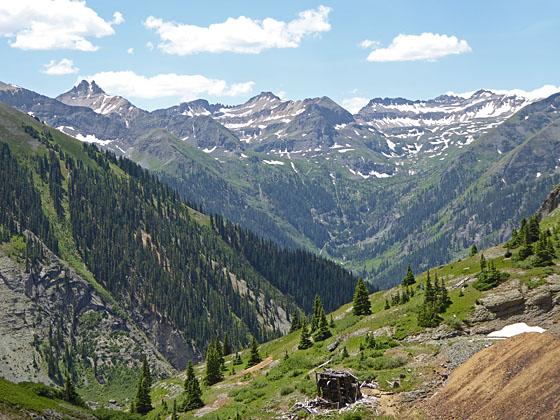
At 2.0 miles pass the remains of an old cabin and other structures on the left. Beyond the ruins the trail climbs a switchback and then crosses a meadow with views of the peaks towering above the head the Telluride valley. Wilson Peak (14,017-ft.), Mount Wilson (14,246-ft.), El Diente (14,159-ft.), Sunshine Mountain (12,930-ft.) and Lizard Head (13,113-ft.) in the Lizard Head Wilderness fill the skyline to the southwest.
The views are short lived. Soon the trail plunges back into the trees and continues its relentless climb, crossing a minor ridge along the way. Occasional openings in the trees offer glimpses of the peaks rimming the Cornet Valley.
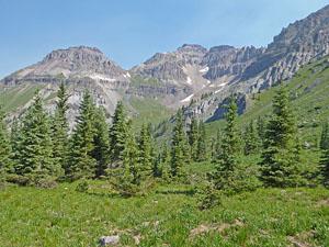
At 2.7 miles the trail turns right (east/southeast) and climbs steeply up a series switchbacks, reaching Liberty Bell basin at 3.1 miles. Here the trees give way to meadows with great views of Greenback Mountain (12,997-ft.) and Mount Emma (13,581-ft.) rising above the head of the Cornet valley. The jagged profile of the St. Sophia Ridge, extending southeast from Mt. Emma, dominates the view to the north.
As you enter the basin the road curves to the right (south). Here you will see a trail heading east (essentially straight ahead) and climbing the basin to the ridge separating Liberty Bell Basin and Marshall Basin. A large rock cairn marks the intersection.
If time and energy allow, I recommend hiking to the ridge. The trail initially ascends along the north side of a line of trees and then curve to the left as it climbs through pretty alpine meadows dotted with wildflowers in season. At 3.5 miles the trail hits the scree slopes beneath the ridge and arcs to the right. Exercise care where the narrow trail crosses a few small landslides.
Reach the top of the ridge 3.6 miles. Here terrific views extend northwest toward Mt. Emma. Dallas Peak (13,741-ft.) rises to the west. The peaks of the Lizard Head Wilderness dominate the view to the southwest. On the east side of the pass views extend down the length of the Marshall Basin. Savage Basin and the road snaking to Imogene Pass are visible to the southeast.
At this point parties can turn around and retrace their steps back to Telluride for a 7.2 mile round-trip hike or descend the Marshall Basin to the Tomboy Mine and then walk back to Telluride along the Tomboy Road. If you like old mine sites and mining ruins your will love the Marshall Basin and the Tomboy mine. The walk, which includes an off trail segment with very steep grades, also includes great views of the Marshall and Savage basins and the Telluride box canyon. The final segment travels along the Tomboy Road, which is not heavily traveled, especially if you avoid the weekends.
To Marshall Basin and the Tomboy Mine
Distance from Trailhead: 6.0 miles (one way)
Ending/Highest Elevation: 11,400-ft.
Elevation Gain: -1,175-ft.
In 1875 John Fallon discovered what is now known as the Smuggler Vein in the upper Marshall Basin. The next year J.B. Ingram and two others staked a claimed called the Smuggler in the lower section of the basin. The mines along the Smuggler Vein consolidated to form the Smuggler-Union Mining Co. twelve years later. These mines, along with the Tomboy Gold Mine in neighboring Savage Basin, were the top producing companies in the San Miguel Mining district until the claims played out in the 1920’s.
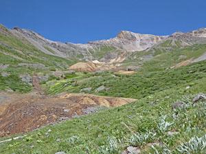
The second half of this loop hike descends through the Marshall Basin, passing the ruins of these mining operations. From the ridge follow the boot beaten path heading northeast along scree clad slopes into Marshall Basin. Use care on the short sections of the trail that cross minor slide areas.
Soon the rocky slopes give way to meadows and the walking is easier. As you look ahead you will see the trail climbing the scree slopes to the north as the trail heads for Virginus Pass, a small notch on the ridge. This pass leads to Governor’s Basin, accessed from Ouray along the Yankee Boy basin road.
After 0.25 miles the trail crosses two small drainages. Ahead you will see the trail start to climb toward the head of the basin. I typically leave the trail here and descend about 100-ft before crossing to the east side of the Marshall Basin.
(Note: There are vestiges of a trail dropping down the west side of the Marshall Basin. In the past I have found parts of this route obliterated by slides/avalanches. I now prefer the route described below.)
Once on the east side of the drainage descend the basin on very steep grassy slopes, skirting the mine tailings and talus fields in the middle of the basin. The goal is to drop down to the next level of the basin and then cross back to the west side of the valley between the two huge tailings piles scattered with mine debris.
As you descend you will see a white cement drainage ditch built to control runoff from the defunct mines. Cross to the west side of the basin above this ditch, selecting a route that avoids crossing tailings piles and other debris. Now descend the west side of the basin, staying to the right (west) of the cement drainage ditch until you hit an old road.
Follow the road down the basin, past more tailing piles and mine ruins. At 4.6 miles the road crosses the cement ditch. On the other side of the ditch follow a gravel road that curves to the left (east) and soon crosses a stream. On the other side of the stream turn right (southeast) on a gravel road and follow the road as it descending along the east side of the basin to meet the Tomboy Road at 5.8 miles, just below the Tomboy Mine. This section of the hike will pass the remains of interesting mining structures including the ruins of the tramway.
Turn left (east) on the Tomboy road and walk a short distance up the road to the substantial ruins of the Tomboy mine at 6.0 miles, located at the foot of Savage Basin. During the mine's heyday in the late 1800’s and early 1900’s, about 900 people lived and worked at the mine. When the ore ran out in 1927 the town went bust and was soon abandoned.
Ghost town enthusiasts will want to wander a half mile up the road to see the remains of the ghost town and more mining structures. Beyond the last structures the road climbs to Imogene Pass (13,114-ft.), a total distance of 2.2 miles from the main ruins at the foot of the basin.
From Tomboy Mine to Telluride
Distance from Trailhead: 10.6 miles (loop)
Ending/Highest Elevation: 8,800-ft.
Elevation Gain: -2,520-ft.
When you are done exploring the mine follow the Tomboy Road back to Telluride. There is some traffic on the road. A few Telluride tour operators run half day tours to the Tomboy Mine and Imogene Pass. Skilled 4WD enthusiasts like to drive the rough road over Imogene Pass, typically starting in Telluride and ending in Ouray. Most like to get over Imogene Pass early in the day to beat any afternoon thunderstorms, which can make the road impassable. As such, traffic tends to be lighter in the afternoon when most hikers will be completing this portion of the loop.
From the mine the road descends to Telluride on moderate to easy grades, traveling above the north side of Savage Creek. At 6.7 miles you will see an old cabin perched above the north side of the road. Beyond the cabin the road crosses a bridge over Marshall Creek and then head southwest high above the north side of Marshall Creek. Ruins and debris of an old tramway are visible below the road. Behind you are nice views up Savage Basin.
At 6.9 miles pass the Bullion Tunnel and the remnants of the Smuggler-Union mine, which includes the ruins of a crusher house and a multistory boarding house, which has now slid down the hill. Nearby are two large boilers, pipes and cables from the tramway that once carried ore to the Pandora Mill, located in the Telluride Valley.
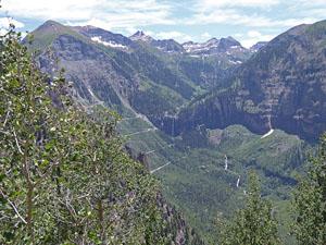
As you continue down the road nice views open to Bridal Veil Falls and the Bridal Veil Basin at the head of Telluride’s box canyon.
At 7.6 miles the trail curves to the right (west), leaving the Marshall Creek Valley and now travels high above the north side of the Telluride valley.
Pass through a tunnel on the road at 7.9 miles. This is a popular spot for photographers.
Beyond the tunnel the road curves into and out of Rover Gulch. Near the head of the gulch are some nice waterfalls cascading down the cliffs above the road. As the road exits the gulch it heads down two long switchbacks. Across the valley to the south are nice views of Bear Creek Valley. Behind you views stretch southeast to Bridal Veil Falls and the peaks rising above the head of the Telluride Valley.
The final section of the trail descends along the road above the town, passing the Jud Wiebe trail junction at 10.2 miles and reaching the top of Oak Street at 10.6 miles.
Elevation Profile
| Buy the BookThis opinionated guide includes all the hikes in the Ouray, Telluride, Silverton and Lake City sections of the website plus info on local services and nearby attractions. |

Driving Directions
Driving Directions from Telluride: Note: Free day-use parking in Telluride is available in the Carhenge Lot just off West Pacific Avenue at the west end of town near the base of Lift 7. Day use parking for larger vehicles is available in the parking lot at the south end of Mahoney Drive, near the west entrance to town. A free shuttle bus, called the Galloping Goose, runs between the parking lots and various stops in downtown Telluride.
There is also free parking in the mountain village lot. From there you can take the free gondola into town and easily walk to the trailhead.
Walking Directions: From Telluride's main street (Colorado Avenue), turn north onto Aspen Street and proceed one block. Turn right (east) onto Columbia Avenue and proceed one block. Turn left (north) onto Oak Street and walk to the end of the street. Turn right (east) on the Tomboy Road, a good dirt road.
Trail Resources
Trail Intro / Trail Photo Gallery / Trail Map
Basecamp(s) Information:
Telluride
Region Information:
Southwest Colorado
Other Hiking Regions in:
Colorado