Details: Lizard Head 
Distance: 7.6 - 11.7 miles (loop)
Lizard Head Wilderness, San Juan National Forest, near Telluride in Southwest Colorado
Hike Facts
- Distance: 7.6 - 11.7 miles (loop)
- Elevation: 10,250-ft. - 12,147-ft.
- Elevation Gain: 1,897-ft. - 2,900-ft.
- Difficulty: strenuous
- Trail Highlights: See Trail Intro
- Basecamp(s): Telluride
- Region: Southwest Colorado
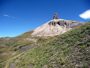
One of the top hikes in the Telluride area, this scenic loop traverses the panoramic spine of Blackface Mountain on its way to the base of Lizard Head Peak (13,113-ft.), an eroded 400-ft. tall spire shaped like the gaping maw of a lizard with its face to the sky.
Trailhead to Black Face Peak
Distance from Trailhead: 7.6 miles (round trip)
Ending/Highest Elevation: 12,147-ft.
Elevation Gain: 1,897-ft.
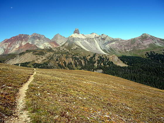
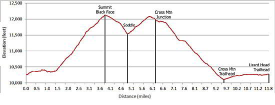
The Lizard Head trail heads northeast from the parking area (see driving directions) on easy grades through pretty meadows and forests of aspen and mixed conifers beneath the steep south face of Black Face Mountain (12,147-ft.). Openings in the trees provide views of Trout Lake and the jagged ridge of 13,000-ft. peaks rising to the east.
After 1.5 miles the trail swings left (west) and starts a moderately steep ascent on switchbacks through spruce-fir forest and meadows, at times skirting the edge of talus slopes, to a junction with the Wilson Meadows trail (heading straight ahead). Keep left, staying on the Lizard Head trail as it climbs steeply up switchbacks on a forested slope. As you climb, the trees gives way to rocky slopes. Reach the ridge leading to the summit of Black Face at 3.0 miles after gaining 1,400-ft.
As the trail attains the ridge crest the rocky slopes give way to alpine meadows dotted with wildflowers. Watch for posts to help guide you through areas where the trail is indistinct.
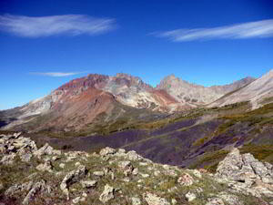
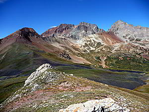
The path now ascends on gentle to moderate grades along the ridge to the summit of Black Face (12,147-ft.) at 3.8 miles. Along the way enjoy spectacular views to the east of Trout Lake and the peaks surrounding the Lake Hope basin, including Sheep Mountain, Pilot Knob, Golden Horn and Vermillion Peak. To the west the skyline is dominated by Lizard Head’s distinctive profile set against a backdrop of the high peaks of the San Miguel Range, including Mount Wilson (14,245-ft.), Gladstone Mountain (13,913-ft.) and Wilson Peak (14,017-ft.). Sunshine Mountain (12,930-ft.) towers above the beautiful emerald green expanse of Wilson Meadows to the north. In the distance to the northeast is the jagged profile of the Sneffels range.
The top of Black Face is a good turn around point for hikers looking for a shorter day or if the weather is taking a turn for the worse.
Black Face to Junction with Cross Mountain Trail
Distance from Trailhead: 2.3 miles (one way)
Ending/Highest Elevation: 12,080-ft.
Elevation Gain: 600-ft.
To continue the loop follow the trail down the west side of the ridge to a saddle between the Wilson Creek and Lizard Head drainages, losing about 630-ft. From the saddle the trail ascends a rocky slope on moderate grades and then swings southwest, traversing high meadows to cross a ridge (12,080-ft.) jutting from Lizard Head’s southern flank at 5.9 miles. From the saddle to the ridge the trail gains about 600-ft.
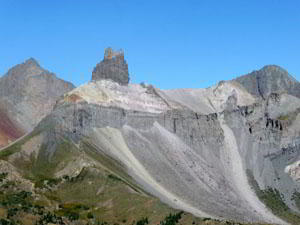
Hikers continuing along this segment of the trail are rewarded with amazing views of Lizard Head towering above the trail. The 13,113-ft. eroded volcanic plug was called, “one of the most difficult of Colorado’s summits to reach,” by Robert Ormes in his 1979 Guide to Colorado Mountains.
Anyone except the most experienced parties thinking about scaling the peak should heed Ormes’ warning, “our advice when you reach the base, take [a] picture and go home.”
Take a break at the top of the ridge to enjoy the spectacular views of the high peaks of the San Miguel Range. From the ridge top the trail loses about 150-ft. as it contours beneath Lizard Head to the junction with the Cross Mountain trail at 6.25-miles.
Optional Bilk Basin Overlook Extension
Distance from Trailhead: 0.6 miles (round trip)
Ending/Highest Elevation: 12,114-ft.
Elevation Gain: 180-ft.
A quick side trip to the Bilk Basin overlook is highly recommended if you have the time and energy. To reach the overlook from the Cross Mountain junction, continue along the Lizard Head trail as it ascends northwest through rocky meadows to a saddle, 0.3 miles from the junction. This wonderful vantage point features panoramic views of Bilk Basin and the jagged peaks and ridges of the San Miguel Range, including Mount Wilson, Gladstone Peak and Wilson Peak, towering above the west side of the basin. After soaking in the views, return to the Cross Mountain trail junction.
Cross Mountain and the Old Railroad Grade to the Lizard Head Trailhead
Distance from Trailhead: 11.7 miles (loop)
Ending/Highest Elevation: 12,147-ft.
Elevation Gain: 2,900-ft.
To complete the 11.7-mile loop, using the Cross Mountain trail and the old Railroad Grade route back to the Lizard Head Parking lot, head downhill on the Cross Mountain trail. The trail descends through meadows and spruce/fir forest, losing over 1,900-ft in 3.25 miles as it drops to a parking area just off Highway 145. (For more information see the Cross Mountain trail description.)
Just before reaching the highway you will see a wide, unmarked trail/dirt road heading left (northeast) through open meadows. The wide path ascends on easy grades along an old railroad grade that essentially parallels Highway 145 for 2.25 miles back to the Lizard Head Pass parking area. (See the Railroad Grade trail description for more information.)
Elevation Profile
| Buy the BookThis opinionated guide includes all the hikes in the Ouray, Telluride, Silverton and Lake City sections of the website plus info on local services and nearby attractions. |

Driving Directions
Driving directions from Telluride: Drive south from Telluride on Colorado 145 for 12.3 miles to Lizard Head Pass. On the right (west) side of the highway is a rest area and interpretive site. Turn right into the rest area and park. The trailhead is located at the northeast end of the parking area. You can also park in a separate trailhead parking area by driving through the rest area (past the restroom) for approximately 1000-ft., then turn right onto a spur road that ends at the Lizard Head trailhead parking area.
Trail Resources
Trail Intro / Trail Photo Gallery / Trail Map
Basecamp(s) Information:
Telluride
Region Information:
Southwest Colorado
Other Hiking Regions in:
Colorado