Details: Albert Premier Refuge and the Col de Balme 
Distance: 6.4 - 6.6 miles (round trip)
French Alps, near Chamonix in The French Alps
Hike Facts
- Distance: 6.4 - 6.6 miles (round trip)
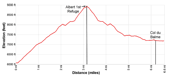
- Elevation: 6,080-ft. - 8,930-ft.
- Elevation Gain: 2,850-ft.
- Difficulty: strenuous
- Trail Highlights: See Trail Intro
- Basecamp(s): Chamonix
- Region: The French Alps
Up-close view of the Le Tour Glacier along with terrific views of Mont Blanc, the Aiguille Rouges, Aiguille du Chardonnet and Aiguille Verte are the rewards of this steep hiking climbing to the Albert 1st Refuge. Visit the Col de Balme on the return trip if time and energy allow.
To Albert Premier Refuge
Distance from Trailhead: 6.4 miles (round trip)
Ending/Highest Elevation: 8,930-ft.
Elevation Gain: 2,850-ft.
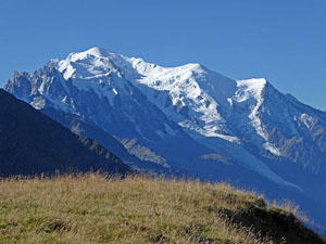
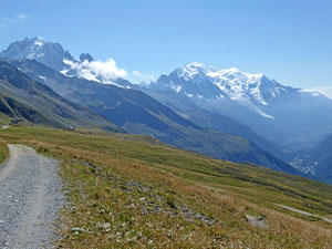
This hike starts in le Tour with a ride up the Telecabine de Charamillon–Balme gondola to the middle station at Chalets de Charamillon (see directions to the trailhead below). Walk north (uphill) as you exit the gondola on a broad dirt track. Soon you will see a trail junction. Straight ahead (continuing up the broad track) is the trail to the Col de Balme. We turn right (northeast) on the path signed for Alpages de Charamillon and Albert 1er hut. From the junction fine views stretch south to Mont Blanc. Across the Chamonix Valley (west) the Aiguille de Mesure and Aiguille Morris rise above the northern end of the Aiguille Rouges massif.
The trail now climbs steep switchbacks through meadows with terrific views of the Chamonix Valley, Mont Blanc and the Aiguille Rouge massif. As you climb the trail makes a wide arc (east then southeast) around the Combe de Vormaine, a large ravine used for off-piste skiing in the winter. As you gain elevation views open northwest to the Grand Perron and the Aiguille Loriaz rising along the north side of the valley above Vallorcine.
After about one mile the trail gains a broad bench and the grade abates a bit. The path now climbs through marshy meadows, crossing the stream draining the Lac de Charamillon at 1.25 miles. At 1.5 miles reach junction with the trail branching left (north) toward the Col de Balme and the top station of the Charamillion-Balme lift. We continue straight ahead (south) toward the Refuge Albert 1er.
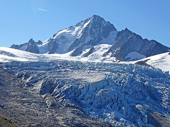
Soon the grade steepens as the path climbs to and then crosses the ridge extending west from the Bec du Picheu at 1.75 miles. Here stunning views open to the Glacier du Tour and the Aiguille du Chardonnet (12,454-ft.). The summit of Aiguille Verte (13,523-ft.) and Mont Blanc rise in the distance to the south. Waterfalls fed by meltwater tumble down the glacial polished stone below the snout of the glacier.
The path now turns east/southeast, ascending switchbacks through meadows along the north side of the le Tour valley. As you climb enjoy ever improving views of the glacier, Mont Blanc and the Aiguille Rouges. After 2.0 miles views open to the Albert 1st refuge, sitting atop a rock ledge above the glacier.
At 2.1 miles the trail makes a short, steep descent to cross a gully. Metal rails affixed to the rock face provide handholds, helpful when the trail is covered in snow/ice.
Past the gully the trail continues ascending through meadows. Along the way enjoy ever improving views of the le Tour Glacier. At 2.5 miles the meadows give way to talus slopes and the trail curves to the right (southeast).
At 2.7 miles the trail climbs atop the moraine on the north side of the valley and then ascends very steep grades up the spine of the moraine. Along the way enjoy terrific, up-close views of the snout and tongue of the glacier. At 3.0 miles the trail climbs rocky switchbacks up to the Albert 1er Refuge (8,881-ft.) at 3.1 miles. The refuge is names after King Albert 1st of Belgium, and avid alpinist. The refuge enjoys fantastic views of the le Tour Glacier, Aiguille du Chardonnet and the Aiguille Rouges. The rugged slopes of the Point des Grands tower overhead.
Use/social trails continue beyond the hut to overlooks above the glacier and then drop down to routes crossing the ice. I recommend going a short distance beyond the hut to find a nice overlook for a picnic at about 3.2 miles. From this perspective you can see the summit of the Aiguille du Tour rising along the north side of the valley and the top of the Grande Fourche to the east. The Aiguille Verte rises to the south of Chardonnet. You will probably also see climbing parties crossing the glacier. (Please do not try to cross the glacier unless you are properly equipped and experienced with glacier travel.)
When you are done admiring the views, retrace your steps to the junction with the trail down to the middle station at 4.9 miles. Here we have a choice, either drop down to the middle station (6.4 mile RT hike) or heading toward the top station and the Col de Balme. If time, energy and the weather permit, I recommend a visit to the Col de Balme and then returning via the upper station to le Tour.
To Col de Balme
Distance from Trailhead: 6.6 miles (round trip)
Ending/Highest Elevation: 8,930-ft.
Elevation Gain: 2,850-ft.
From the junction the trail to the Col de Balme ascends to cross the outlet stream for the Lac de Charamillon at 4.9 miles. The trail now travels along easy grades, climbing slightly to cross a ridge extending from the les Grandes Autannes at 5.2 miles. From the ridge crest descend to a bench and a junction at 5.8 miles where a trail branches left (northwest) to the top station of the Charamillon–Balme lift. (The top segment is a chair lift that descends to the gondola at the middle station.) A short distance beyond is a second junction dropping to the lift. We continue straight ahead (north) toward the Col de Balme.
At 5.9 miles the trail levels and we reach a third junction with a trail branching left toward the Col des Posettes. We stay on the trail toward the Col de Balme. The area around the junction features fine views of Aiguille Verte and Mont Blanc to the south.
Reach the Col de Balme (7,188-ft.), on the French/Swiss border, at 6.2 miles. Nearby is the Refuge de Balme, a favorite stop along the Tour du Mont Blanc. Looking northeast enjoy distant views of the high peaks of the Bernese Oberland rising above the Rhone Valley. To the south are great views of Mont Blanc and Aiguille Verte. Aiguille Rouges tower above the Chamonix Valley to the west/southwest.
When you are done taking in the views, retrace your steps to the junction with the trail to the top station of the Charamillon–Balme lift. Bear right at the junction, reaching the lift station at 6.6 miles. Take the chairlift down to the gondola and then the gondola to le Tour.
Elevation Profile
Driving Directions
Chamonix to le Tour: The #2 or V2 buses are the easiest way to get to le Tour. The buses stop at the Chamonix Sud, Chamonix Center and Place Mont Blanc along with other locations in the l’Arve valley. The ride from Chamonix Center to le Tour takes 26-34 minutes depending on the line. See the main Chamonix Tourist Information site for the latest bus and train schedules.
Le Tour to Chamonix: Take the #2 or V2 buses to return from le Tour to Chamonix. From le Tour it is a 26 – 34 minute ride back to Chamonix Center. See the main Chamonix Tourist Information site for the latest bus and train schedules.
Trail Resources
Trail Intro / Trail Photo Gallery / Trail Map
Basecamp(s) Information:
Chamonix
Region Information:
The French Alps
Other Hiking Regions in:
France