Details: Grinnell Glacier 
Distance: 7.2 - 10.4 miles (round trip)
Glacier National Park, near Many Glacier in Glacier Natl Park, MT
Hike Facts
- Distance: 7.2 - 10.4 miles (round trip)
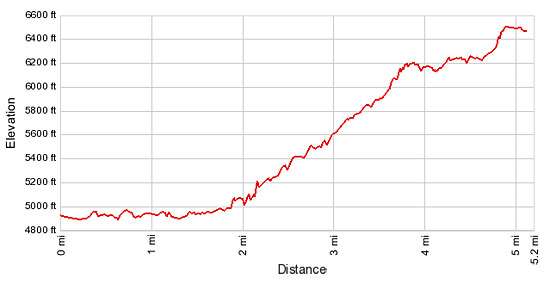
- Elevation: 4,890-ft. - 6,510-ft.
- Elevation Gain: 1,620-ft.
- Difficulty: strenuous
- Trail Highlights: See Trail Intro
- Basecamp(s): Many Glacier / St Mary
- Region: Glacier Natl Park, MT
This popular hike, with fabulous views of the Cataract and Grinnell valleys, climbs through pretty meadows and along rock ledges to Upper Grinnell Lake and Grinnell Glacier, cradled in a dramatic cirque along the Continental Divide.
To Grinnell Glacier
There are two ways to access the Grinnell Glacier trail. The first begins at the Many Glacier Picnic area, travels around the western shore of Swiftcurrent Lake and then follows the North Shore Lake Josephine trail for 0.8 miles to the Grinnell Glacier trail, which bears right, climbing through meadows and stands of trees above the lake.
The second option takes the two-stage boat tour leaving from the Many Glaciers Hotel. The first stage of the trip crosses Swiftcurrent Lake. At the head of the lake tour participants disembark and walk 400 yards to the foot of Lake Josephine where a second boat waits to take the tour to the head of Lake Josephine. At the head of Lake Josephine trails connect to the Grinnell Glacier Trail in 0.4 miles.
Without the shuttle boats the hike is 10.4 miles long. Taking the boats both ways reduces the round trip hiking distance to 7.2 miles. Riding the boat one way and walking the North Shore trail the other directions shortens the hike to 8.8 miles.
This description assumes hikers take the boat both directions. See the Grinnell Lake hike for the description of the trail starting and the Many Glacier Picnic Area and traveling along the North Shore of Lake Josephine.
From the boat dock at the southwest end of Lake Josephine, follow the trail to the right (southwest) for a short distance to the junction with the trail to Grinnell Lake. Turn right at the junction in the direction of the Grinnell Glacier trail. Follow the trail as it curves to the northwest around the head of Lake Josephine, traveling through forest and willows.
A quarter mile from the dock the trail crosses a wooden bridge over Cataract Creek. A tenth of a mile beyond the bridge the trail arrives at a second trail junction. Take the Grinnell Glacier Connector trail to the left, which climbs the hillside toward the Grinnell Glacier trail. The path to the right is the North Shore Lake Josephine trail heading back to the Many Glacier Picnic area and the Many Glacier Hotel.
The steep trail ascends over 100-ft. in a tenth of a mile to the Grinnell Glacier trail. Turn left (west), toward Grinnell Glacier. The trail to the glacier curves around a rock outcropping and then begins an ascending traverse through meadows and trees on moderately-steep grades along the southern flanks of the unnamed peaks between Mt. Grinnell and Grinnell Point.
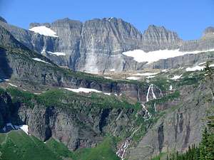
From the meadows fine views extend south up the Cataract Valley. The peaks along the Continental Divide, Pollack Mountain (9,190-ft.), Bishops Cap (9,127-ft.) and Mount Gould (9,553-ft.), tower above the western side of the valley while Cataract Mountain (8,180-ft.) rises to the south. Morning Eagle Falls tumbles down a rock ledge on the valley floor.
As the trail gains altitude views open to the cirque formed by the serrated ridge connecting Mt. Gould (9,553-ft.) and Mt. Grinnell (8,851-ft.) at the head of the Grinnell Valley. The ridge is part of the Garden Wall, a spectacular formation along the Continental Divide. Grinnell Falls cascades down the sheer cliffs of the valley’s headwall. Salamander Glacier lies cradled on a ledge beneath the top of the Garden Wall.
As you ascend, the trail passes through pretty alpine meadows sprinkled with wildflowers. Occasional steams, cascading down crevasses in the steep, rocky slopes above the trail spill over the path. Far below the trail are the turquoise waters of beautiful Grinnell Lake. As you hike, keep an eye out for mountain goats and big horn sheep on the cliffs overhead as well as the meadows below the trail.
At 1.6 miles the trail climbs a few switchbacks. Not far beyond the switchback views open to the Grinnell Glacier, residing on a shelf above beautiful Grinnell Falls. Beyond the switchbacks the trail curves to the northwest, ascending along the steep southeastern flanks of Mt. Grinnell.
The grade abates at 2.2 miles as the trail traverses narrow ledges along a cliff face. People with a fear of heights may have problems with this section of the trail.
Reach a picnic area with log benches and an outhouse at 3.1 miles. The subalpine firs and limber pines offer a few shady spots to take a break before tackling the final stiff climb to the Grinnell Glacier.
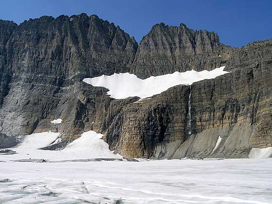
Past the picnic area a series of steep switchbacks climbs a glacial moraine to a stunning viewpoint on the eastern shore of Upper Grinnell Lake at 3.6 miles. (This point is 5.2 miles from the Many Glacier Picnic area trailhead.) Grinnell Glacier and Upper Grinnell Lake lie nestled beneath the cirque’s sheer, rugged rock walls. Ice often extends to cover large portions of the lake’s milky turquoise waters.
Above the right side of the Grinnell Glacier a waterfall spills from the ledge cradling the long, narrow expanse of the Salamander Glacier. The two glaciers were once connected before warmer weather caused them to shrink and separated. The Gem Glacier, the smallest in the park, fills a shallow rock-rimmed basin to the left of a notch on Mt. Gould’s northwest rim.
Grinnell Glacier is named after George Bird Grinnell, who first visited the area in 1885 while he was the editor of Field and Stream, a popular outdoor magazine. Over the ensuing years he explored the area and advocated for the establishment of Glacier National Park.
After you are done admiring this dramatic landscape, retrace your steps to the trailhead. As you descend enjoy wonderful views of Grinnell Lake and Lake Josephine on the valley floor. In the distance is Lake Sherbourne.
Elevation Profile
Driving Directions
To the Many Glacier Picnic Area:
From St. Mary: Drive north on US 89 for 8.5 miles and turn left onto Route 3, signed for Many Glacier. The turn is just before the town of Babb, MT. Continue along Route 3 for 11.9 miles to the Grinnell Glacier trailhead at the Many Glacier Picnic area, located on the left (south) side of the road.
From the Many Glacier Hotel Complex: Head west on Route 3 for 0.5 miles to the Grinnell Glacier trailhead at the Many Glacier Picnic area, located on the left (south) side of the road.
To the Many Glacier Hotel Complex and the Boat Dock:
From St. Mary: Drive north on US 89 for 8.5 miles and turn left onto Route 3, signed for Many Glacier. The turn is just before the town of Babb, MT. Continue along Route 3 for 11.4 miles and turn left on the road leading to the Many Glacier Hotel. In a short distance make a second left on the road leading up the hill to the large parking lot in the rear of the complex. Walk through or around the hotel to the boat dock on the west side of the building.
Via Boat: The Glacier Park Boat Company runs boat tours of Swiftcurrent Lake and Lake Josephine. Hikers can ride the boats either one way or round trip to shorten hiking distances. The two stage boat trip starts from the west side (lake side) of the Many Glacier Hotel and crosses Swiftcurrent Lake. At the end of the lake tour participants disembark and walk 400 yards to the foot of Josephine Lake where a second boat awaits to take the tour to the head to the head of Lake Josephine. At the head of Lake Josephine trails connect to destinations in the Grinnell Valley. See the The Glacier Park Boat Company website for schedules and costs.
Trail Resources
Trail Intro / Trail Photo Gallery / Trail Map
Basecamp(s) Information:
Many Glacier / St Mary
Region Information:
Glacier Natl Park, MT
Other Hiking Regions in:
Montana