Details: Twin Falls and Upper Two Medicine Lake 
Distance: 2.2 - 9.8 miles (round trip)
Glacier National Park, near Two Medicine in Glacier Natl Park, MT
Hike Facts
- Distance: 2.2 - 9.8 miles (round trip)
- Elevation: 5,180-ft. - 5,520-ft.
- Elevation Gain: 140-ft. - 340-ft.
- Difficulty: easy
- Trail Highlights: See Trail Intro
- Basecamp(s): Two Medicine / St Mary
- Region: Glacier Natl Park, MT
This easily hike features stunning views of the peaks surrounding the Two Medicine Valley, visits a beautiful pair of cascading waterfalls and a end at a scenic lake ringed by rugged peaks.
To Twin Falls
Distance from Trailhead: 2.2 miles (round trip)
Ending/Highest Elevation: 5,320-ft.
Elevation Gain: 140-ft.
To Twin Falls Trail Junction from the boat dock at the foot (east end) of Two Medicine Lake
Hikers can ride the tour boat on Two Medicine Lake (5,164-ft.) to shorten the distance to Twin Falls/Upper Two Medicine Lake by 2.5 miles (one-way) or 5.0 miles (round-trip). The boat travels to the head (west end) of the lake where trails connect to a variety of destinations, including Twin Falls and Upper Two Medicine Lake.
The cruise across the lake is accompanied by a commentary on the Blackfoot Indian folklore related to the Two Medicine Valley and offers stunning views of Painted Teepee Peak (7,650-ft.), Sinopah Mountain (8,245-ft.), Lone Walker Mountain (8,502-ft.), Finsch Peak (9,225-ft.) and Rising Wolf Mountain (9,513-ft.). Consult the Glacier Park Boat Company (http://www.glacierparkboats.com/) website for schedules and tour costs.
From the boat dock at the head of the lake a trail heads west on easy grades, crossing boardwalks as it passes through a marshy area. In a short distance arrive at the junction with the South Shore trail, branching off to the left. Continue straight ahead. Soon the trail enters the woods.
Cross a bridge over Two Medicine Creek at 0.6 miles and reach a second trail junction at 0.75 miles. Bear left (west) on the trail to Twin Falls (0.3 miles) and Upper Two Medicine Lake (1.5 miles). The trail to the right (northeast), the Dawson Pass Cutoff trail, connects with the Dawson Pass and North Shore trails.
[Skip the next section and continue reading “To Twin Falls and Upper Two Medicine Lake”]
To Twin Falls Trail Junction via the North Shore Trail
From the North Shore trailhead at the outlet of Pray Lake head west, crossing the bridge over the outlet stream. At 0.1 miles reach the junction with the Pitamakan Pass trail branching to the right. Bear left on the North Shore trail toward Twin Falls and Dawson Pass.
Follow the trail as it traverses the north side of Pray Lake, passing through some trees and then open meadows with nice views of Appistokie Peak (8,164-ft.) rising to the south across the lake. Reach the northeast end of Two Medicine Lake after walking a little over 0.25 miles.
The trail now travels on easy grades along the north shore of Two Medicine Lake beneath massive Rising Wolf Mountain (9,513-ft.), passing through stands of conifers and meadows. The meadows, created by avalanches plowing down the slopes of Rising Wolf, feature wonderful views of the peaks to the south/southwest including Mt. Ellensworth (8,591-ft.), Never Laughs Mountain (7,641-ft.), Grizzley Mountain (9,067-ft.), Painted Tepee Peak (7,650-ft.) and Sinopah Mountain (8,245-ft.), which towers above the head of the lake.
At 0.8 miles views open to a beautiful waterfall tumbling down Rising Wolf’s craggy slopes and lush meadows. The mountain’s open slopes and avalanches chutes are favorite habitats for bears foraging for food. Keep an eye out for bears on the upper slopes and be sure to make noise so you do not surprise one of these majestic creatures foraging in the high brush near the trail.
Climb a short, moderately steep slope up a mound at the end of an avalanche chute at 2.0 miles, gaining 100-ft. in 0.2 miles. At the top of the slope rock hop across the stream cascading down the chute and then follow the trail as it drops down the other side of the mound.
Reach the northwest end (head) of the lake at 2.5 miles. Soon the trail enters the trees and begins a moderate climb to a trail junction at 3.1 miles. The trail to the right climbs to No Name Lake and Dawson Pass. We turn left on the Dawson Pass Cutoff trail toward the Upper Two Medicine Lake Trail.
Reach the junction with the Upper Two Medicine Lake Trail at 3.2 miles. Turn right toward the lake and Twin Falls. Soon the distinctive spire of Pumpelly Pillar (7,625-ft.), an impressive knife-shaped wall of rock, is seen rises above the trees to the west.
To Twin Falls
[In this section the trail mileage is listed as A/B where A reflects the distance from the boat dock and B is the distance from the North Shore trailhead.]
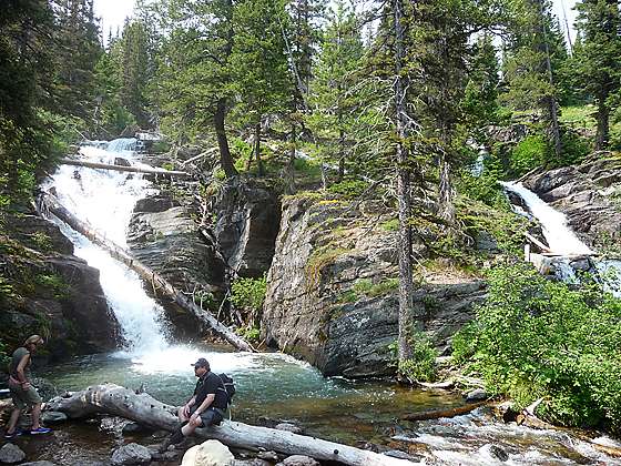
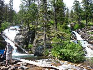
The trail to Twin Falls and Upper Two Medicine Lake crosses a log bridge over Two Medicine Creek and soon arrives at the junction with the spur trail to Twin Falls at 0.95/3.4 miles. Turn right and follow the trail for 0.1 miles to the falls, a beautiful pair of waterfalls cascading down a rocky hillside. This is a popular spot so do not expect solitude. After enjoying the falls retrace your steps back to the trailhead/boat dock.
To Upper Two Medicine Lake
Distance from Trailhead: 9.8 miles (round trip)
Ending/Highest Elevation: 5,520-ft.
Elevation Gain: 340-ft.
Parties looking for a longer hike will want to continue to Upper Two Medicine Lake. To reach the lake backtrack to the junction with the Upper Two Medicine Lake trail and turn right (west). Follow the trail through spruce-fir forest and meadows beneath the south flanks of Pumpelly Pillar for 1.2 miles to the lake. Reach the Lake at 2.4 miles from the boat dock or 4.9 miles from the North Shore trailhead.
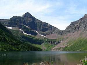
Scenic Upper Two Medicine Lake (5,403-ft.) is nestled in a U-shaped glacial valley. Lone Walker Mountain (8,502-ft.) towers above the head of the lake while the steep slopes of Mt. Helen (8,538-ft.) rise above the lake’s northwestern shore. Mt. Rockwell (9,272-ft.) looms above the valley to the south. Look for mountain goats and bighorn sheep on the cliff high above the lake. Four backcountry campsites are situated near the foot of the lake 2.4 miles from the boat dock or 4.9 miles from the North Shore trailhead.
After taking in the views and possibly trying your luck at some fishing, retrace your steps to the boat dock or trailhead.
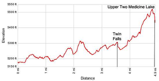
Elevation Profile
Driving Directions
From Two Medicine: From US Highway 2 in Two Medicine, turn north on Montana-49 N. Drive 4.1 miles on 49-N and turn left on Two Medicine Road. Travel along Two Medicine Road to 7.2 miles. Turn right (north) on the road to the Two Medicine Campground. Follow the main campground road to its end and the Two Medicine North Shore trailhead at the foot of Pray Lake, located to the northeast of Two Medicine Lake.
From St. Mary: Head south on Rt. 89 for 18.9 miles and turn right onto MT 49 S. Follow the narrow, twisty road for 7.5 miles and then turn right onto Two Medicine Road. Travel along Two Medicine Road to 7.2 miles. Turn right (north) on the road to the Two Medicine Campground. Follow the main campground road to its end and the Two Medicine North Shore trailhead at the foot of Pray Lake, located to the northeast of Two Medicine Lake.
Via Boat: The Glacier Park Boat Company (http://www.glacierparkboats.com/) runs boat tours on Two Medicine Lake. The boats travel to the head of the lake where trails connect to a variety of destinations, including the trail to Dawson Pass. Hikers can ride the boats either one way to round trip to shorten the hiking distance to the pass.
The dock is located near the foot of Two Medicine Lake. To reach the boat dock from US Highway 2 in Two Medicine, turn north on Montana-49 N. Drive 4.1 miles on 49-N and turn left on Two Medicine Road. Travel along Two Medicine Road for 7.3 miles to the parking area at the end of the road. The boat dock and kiosk for purchasing tickets is at the southwest end of the parking area. During the height of the summer it is advisable to get reservations a day ahead of time. See the Glacier Park Boat Company website for departure schedules, costs and contact information.
Trail Resources
Trail Intro / Trail Photo Gallery / Trail Map
Basecamp(s) Information:
Two Medicine / St Mary
Region Information:
Glacier Natl Park, MT
Other Hiking Regions in:
Montana