Details: Sperry Glacier 
Distance: 7.6 - 18.4 miles (round trip)
Glacier National Park, near West Glacier in Glacier Natl Park, MT
Hike Facts
- Distance: 7.6 - 18.4 miles (round trip)
- Elevation: 3,190-ft. - 8,025-ft.
- Elevation Gain: 4,835-ft. - 4,835-ft.
- Difficulty: strenuous
- Trail Highlights: See Trail Intro
- Basecamp(s): West Glacier
- Region: Glacier Natl Park, MT
This spectacular hike climbs through gorgeous Glacier Basin, passes beautiful waterfalls and lovely alpine lakes before climbing to scenic Comeau Pass, with panoramic views of Glacier’s high peaks. A short walk beyond the pass leads to the ice expanse of Sperry Glacier.
To Sperry Glacier
From the Sperry Chalet or Campground
Distance: 7.6 - 8.2 miles RT from Sperry Chalet or Campground
Starting Elevation: 6,420-ft. (at junction)
Maximum Elevation: 8,025-ft.
Elevation Gain: 1,605-ft.
From the Gunsight Pass Trailhead near Lake McDonald Lodge
Distance: 18.4 miles RT
Trailhead Elevation: 3,190-ft
Maximum Elevation: 8,025-ft.
Elevation Gain: 4,835-ft
The hike to the Sperry Glacier is an extremely long day hike, covering 18.4 miles and climbing over 4,800-ft. Only extremely fit, well acclimated hikers should attempt the trail as a day hike. The better option is to score one of the coveted rooms at the Sperry Chalet or a site at the Sperry Campground, hike to the Chalet/Campground on the first day and then visit the Sperry Glacier later that afternoon or the next morning. The hike from the Chalet or the campground is a 7.6- to 8.2-mile RT hike gaining 1,605-ft.
The trail to the Sperry Glacier, Chalet and campground starts at the Gunsight Pass Trailhead, located across from the Lake McDonald Lodge on the east side of the Going-to-the-Sun Road (see driving directions below). The first 5.8 miles of the hike follows the Gunsight Pass trail to the junction with the Sperry Glacier trail. See the Sperry Chalet trail description for more information about the section of the hike.
Sperry Glacier Trail to Comeau Pass and the Sperry Glacier Overlook
Note: The Sperry Glacier junction with the Gunsight Pass trail is 0.4 miles below Sperry Chalet and 0.7 miles below the Sperry Campground. The mileage in the description assumes you are starting at the junction. Add the appropriate mileage if starting from the Chalet or the Campground.
From the junction of the Gunsight Pass and Sperry Glacier trails, follow the Sperry Glacier trail as it travels through trees and then meadows along the east side of Glacier Basin. Soon the trail starts ascending the slopes along the east side of the basin, crossing a large talus field and then a creek below lovely Feather Woman Falls at 0.4 miles. Beyond the falls the trail climbs around the head of the basin. In season this section of the trail is lined with pretty wildflowers.
At 0.7 miles the path crosses the Akaiyan Creek and then ascends the basin’s western wall on long switchback through meadows and talus. The climb is accompanied by fine views of Feather Woman Falls and Lincoln Peak. At 1.1 miles the grade steepens as the path climbs short steep switchbacks. The Akaiyan Falls spills over rock slabs to the right (east) of the trail.
After 1.5 miles and over 1,000-ft. of elevation gain the trail crosses the Akaiyan Creek near the top of the headwall and then traverses a boulder strewn shelf to the east of the falls. From the shelf enjoy great view of Lincoln Peak and the high summits to the southwest of the Park including Mount Penrose, Great Bear Mountain and Triangle Peak.
At 1.75 miles the trail again ascends, reaching the top of the headwall and the upper basin at 1.9 miles. Here the trail travels through a landscape of rock outcropping and small alpine meadows. Soon views open to a beautiful Feather Woman Lake (7,538-ft.). Above the lake waterfalls on the inlet stream tumble down rock ledges.
Cross Feather Woman Lake’s outlet stream at 2.0 miles. The crossing is just above a small falls. Flat rocks place along the broad crossing help keep your feet dry. Watch for mountain goats in the upper basin. They are habituated to hikers and are easy to photograph. Please remember they are wild animal and keep your distance.
Beyond the crossing the trail ascends along the west side of the upper basin on moderately-steep to steep grades. As you climb, turn around for views of Great Northern Mountain and Mount Grant to the south. Depending on the time of year you will likely cross a few lingering snow fields on the climb.
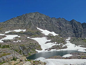
At 2.4 miles the trail reaches the next tier of the upper basin where Akaiyan Lake lies cradled in a rocky bowl. Waterfalls tumble down the high ledge above the north side of the lake. The path now traverses shelf high above the west and north sides of the lake. This is a highly scenic area with waterfalls spills down the steep cliffs above the trail.
At 2.6 miles the trail starts the steep ascent up switchbacks to Comeau Pass. As you climb enjoy views of a waterfall plunging down the sheer cliffs below the pass. Edwards Mountain looms above the basin to the west. Below you are fine views of Akaiyan and Feather Woman Lakes set against backdrop of the high peaks to the southwest.
At 2.8 miles reach a steep set of rock steps chiseled into the cliff below the pass. A steel cable along the steps provides a level of security when the steps are covered in snow/ice.
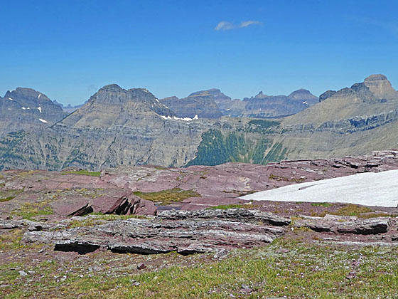
Reach Comeau Pass (8,025-ft.) at 2.85 miles. Here a stunning panorama of Glacier’s high peaks towering above Avalanche Basin, the Logan Pass area and beyond fills the skyline to the north. Visible peaks include Bearhat Mountain, Mount Cannon, Clements Mountain, Reynolds Mountain, Pollack Mountain, the Bishops Cap and Mount Gould, to name a few. To the northeast Fusillade Mountain rises beyond the Gunsight Mountain ridge. Closer at hand Edwards Mountain rises above the basin to the west. During my last hike a large herd of Mountain Goats were reclining on the ledges above the pass.
At the pass a sign indicated that the Sperry Glacier is 0.6 miles further. The path to the glacier heads northeast across the broad pass and then descend about 50-ft. to a cairned/boot-beaten path across permanent snowfields. Along the way the trail climbs a few stone ledges. As you proceed northeast views open to Mount Vaught, McPartland Mountain and Heavens Peak to the west.
At 3.4 miles the trail reaches a stake marking the end of the route and the Sperry Glacier Overlook. Here views stretch across the icy expanse of the Sperry Glacier. Gunsight Mountain (9,258-ft.) towers above the ice field to the west. Below the glacier are a number of meltwater ponds that feed waterfalls in Avalanche Basin. To the north are more great views of the high peaks around the Logan Pass area and beyond.
When you are done taking in the scene retrace your steps, enjoying the gorgeous views all over again on the return journey.
Elevation Profile
Driving Directions
From West Glacier, MT: From the junction of US-2 and the Going-to-the-Sun Road, turn northwest on the Going-to-the-Sun Road and follow the road 2.0 miles. Turn right at the junction with the Apgar Visitor Center to stay on Going-to-the-Sun Road and continue along the road for 8.9 miles. A crosswalk across the road signals the beginning of the Gunsight Pass/Sperry Chalet Trail on the right (east).
Take the next left on an unmarked one-way road with a small wood building at the corner. Along this road you will find parking for the Lake McDonald Lodge and the trailhead. At the first intersection turn left on the road that runs parallel to the front of the Lodge. A short distance beyond take your next left on a one-way road heading back to the Going-to-the-Sun road. This road also includes parking for the Lake McDonald Lodge and the trailhead. Find a parking spot along the road and then walk the rest of the distance up the road to the Going-to-the-Sun Road. Carefully cross the Going-to-the-Sun Road using the crosswalk. The trailhead for the Gunsight Pass trail to Sperry Chalet is on the east side of the road.
The parking lots around the Lake McDonald Lodge can be very congested. Typically in the morning, when people are checking out, you should be able to find a space. Alternative take the shuttle bus from the Apgar Visitor Center, a better option during the height of the summer when parking is limited.
Trail Resources
Trail Intro / Trail Photo Gallery / Trail Map
Basecamp(s) Information:
West Glacier
Region Information:
Glacier Natl Park, MT
Other Hiking Regions in:
Montana